Unless otherwise indicated, the photos on this page are by Okey L. King.

Off-The-Beaten-Track Auto Tours
These are tours you won't find on the official West Virginia Tourist Pages. I won't take you anyplace that I haven't aready been before. So, don't worry about getting your car a little dusty and let's go.
Back Country Monroe County Tour
Well here we are right smack in the middle of White Sulphur Springs sitting at a red light. The light has turned and we're on Mountain Avenue/Tuckahoe Road and we've past the "Buzz In," and are driving right on up the street past Shanklin's Funeral home. Passing under Interstate, we are on Tuckahoe Road and are headed up Tuckahoe "Holler."
Soon we pass the White Sulphur Limits and we are driving up a narrow blacktop road through a narrow valley bordered my high hills (or mountains) on both sides. Over on the hillside to our left a couple of diesel locomotives labor at the head of a long train of coal cars. Those locomotive are making a racket, but we are leaving them behind.
After buzzing along a straight stretch, we have to slow at curve and a narrow bridge. Before we crossed the bridge, we saw a road entering from the left. This is now called State Line Road, but it was once the old Sweet Springs Road. If fact, until this point, we had been traveling on that old road that led from the Greenbrier Resort to the old spa at Sweet Springs. That road will take you though a gap to U.S. Rt. 311.

.....This pond and the land on our left is part of the old Neil Caldwell Place. He was one of the local characters, but he has passed now. I preached his furneral.
Were speeding along again but, topping a little rise, were confronted by a relic from the "horse and buggy days." In front of us is an old railroad underpass the the CSX Railroad refuses to replace. Now, we taker slow and watch for cars coming in the other direction because there is only one lane. If we stop after we get though the tunnel, we could walk up to the track and a short distnce east and find the famous Allegheny Tunnel. At the top of the underpass, the old Tuckahoe Depot once stood. There was a time when a feller could get on a train here and go to White Sulphur or Roncerverte or to Allegheny, Virginia on the other end of the tunnel. Or, you could even catch a train all the way to Ohio. The Tunnel goes through Aleghenny Mountain.
.....But we're not stopping. After winding around a few curves, we come to a new addition to Tuckahoe Valley. This is our own "pork barrel" project. Swinging to the left and around we pass the Tuckahoe Dam and Lake which we have though the efforts of Senator Byrd.  The project was the brain child of the operators of the Greenbrier Hotel and some of the folks downtown. It stands as a endorsement of the fact that, if somebody wants your land and has the power to take it, they will. On the other side of teh lake is the Alpaugh Cemetery where we buried Neil.
We have just barely passed the lake when we see a little white church building on the left up on the bank. This the Peniel Pentecostal Holiness Church and the date on the corner stone of the church says 1923.

Photo by Jonathan Daniel King, grandson of Okey L. King A half-mile pact the church, we can look over to the left and, if the site hadn't been reclaimed by the woods, we might see where the old brickyard once stood. The bricks used to build the brick streets of Roncerverte were made here.
We have wound around some curves and have reached a spot where another road comes in from the left. The sign says, "Broad Hollow Road," but the locals call it Ramsey "Holler." If were were ambitious, we could park the car and walk up this road up the hollow and then follow it up the side of the mountain to the top. We would be on Allegheny Mountain in Virginia not far from what is called Big Ridge which once had a "right smart sized" community that traditions says was settled by deserters from the Confederate Army. There was once a school, a church, and a mill. There is still a church up there .
Driving up the road, we glance to the mountain on the right. That's Kate's Mountain where Kate Carpenter is supposed to have hid her children from the Indians. Stradling this mountain and going down into the Valley on the other side, Greenbrier State Forrest offers us a pleasant day if that was what we wanted to do. But, were out driving today, were heading on up the valley on the narrow road which is getting steeper. We drive slowly by my deacon Woody Cox's house and wave as he is standing out in the yard with his friend Lum. It looks like they are getting ready to "take off" somewhere on their bicycles.
We have just rounded a couple of steep curves and have reached the top. This is the "Divide" that seperates Greenbrier County From Monroe County. Cruising down hill, we are finally in the wilds of Northern Monroe County. This is a county that dosen't have a stoplight, but it does have some stop signs and we have just come one.
We have reached the "Four Corners" at the community of Glace. If we go right, we could go back to the cabin where you are staying and spend the rest of the day in the Forrest. But, were not going to do that of course. We could go straight ahead and you could be able to tell folks that you have been to Hollywood...West Virginia that is. Were not going that way either. Were turning left, and here we go.
This mountain that were climbing on a gravel road is Cove Mountain. When we get on top, we will cross the ridge and go down into Cove Creek Valley. Well, we made it to the top and were going though the woods on a fairly level place. Right over there to the left, if we stopped and went into the woods, we would find an old cemetery with nothing but rocks as markers. There are a lot of those old cemeteries in these mountains. Folks came, and folks pulled up stakes to try their foutunes some place else leaving their dead behind. Hold on now we have a long hill to go down and it's got a few good curves. Not used to these old hills are you? Well, here we are at the bottom.
This road that we've come to is Cove Creek Road and this once was the little town of Pedro. If we turn right, we can go down the valley a short peice and then turn left and climb up on Big Ridge. You cannot go down the creek. It goes through a gorge and the road is impassable now. We're not going that way anyway. Were turning right.
When we were back on the other side of the mountain, we were on Laurel Creek. You would have little trouble believing that Laurel Creek was sending its waters to the Mississippi. But, that creek over there, Cove Creek, it's sending its waters down to the James and on to the Atlantic Ocean. Very few people know that there is a lettle section of Monroe County that is drained by the James River. Cove Creek helps make Dunlap creek, Dunlap Creek enters the Jackson River at Covington, and the Jackson River joins with the Cowpasture River to form the James. You folks look over there at those nice homes folks have built here, but I have to keep my eyes open for potholes in this road. Those ponds there are made by beavers, and it looks like a good place to fish but the fellers that own it would take a dim view of our doing that. Let's stop here a minute at this old church. That's Wiley's Chapel and it isn't used anymore. But, out there in the cemetery lie the bones of some of the first settles that came over the mounains into this area.
 photo by Okey L. King
You will notice that many of these graves have only rocks for markers also. Over there behind the church somewhere is the Cove Creek Spring. It gives birth to Cove Creek. Let's get started again. Did you notice that we went over a rise and are now going down. Were over on Devil Creek now and were back in the Mississippi River Basin. You say, "What's this were coming to?" This is Moncove Lake State Park. If you didn't forget to put the lunch in, let's stop at the picnic area and rest a little and eat some of that chicken and "tater" salid.
We will continue this tour after we have rested a bit.
photo by Okey L. King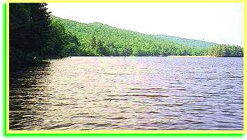
(This is Moncove Lake State Park. Situated in the mountains of Northern Monroe County, Moncove Lake boasts a first class camping and picnic area. Not only dose the lake offer great catfish, bass, and panfish sport, it is now stocked with trout. For a great place to get away from the hustle and bustle of life, Moncove Lake State Park is hard to beat. I have spent many pleasant hours here.)
Hey! Come on! get back in the car! it's time to get going again!
What were you all doing down there back the lake anyway? Well...whatever, were going down Devil Creek now. No, I don't know why they call it Devil Creek. No, I don't know every thing. There's a Little Devil Creek too, and they both run into Second Creek. Scond Creek runs into the Greenbrier River between Ronceverte and Fort Spring. There used to be several little towns on the creek, but they're gone now. At the place where one used to be, there's a public fishing area where you can only use flies and have to put the fish back after you catch them. It's a pretty place and you can still see a few of the old buildings and the remains of a swinging bridge. Say you would like to see it? Well, we'll see. We might if we come back around that way. Now, were getting close to Route Three. Yep, here we are. If you turn right here, you will go to Union. That is, if you don't turn off first. There are just a whole lot of ways you can go back through the country. But, were going left. That's second Creek we just crossed and, just around the bend is the town of Gap Mills.
Quite a few Mennonites have setteled in this area. They have some nice farms, and some good business. Here in Gap Mills, there is a country store that the Mennonites operate where they sell good things like cheese and stuff. Maybe while your on vacation here this week, you can drive over by yourselves and check it out. Right now, were turning left here and heading towards Zenith. What's at Zeinith? You'll just have to wait and see. Just enjoy the beautiful scenery that your going though in this wide mountain valley. I think that I will quit yakking for awhile and let you just enjoy the what you see. But, did you evert see so many shades of green?
When we get to almost to Zenith, I'll have something else to show you.
That big mountain up there on the left that you been looking at, that's Peters Mountain. When we get to the top of the next rise, there will be a road coming off of the mountain. You can go up and over the other side and be in Waitsville on Potts Creek. Potts Creek also empties its water into the James. Down the road several miles, there is a farm that raises bison. They have a bog "shindig" every year. But, on top of the mountain before you go down the other side, there is a parking lot and you can walk a short distance to what is called "Hanging Rock" which is a hawk observation post. I believe that it is one of the best overlooks in the state if not the best. Maybe you might want to drive over here in the morning. Peters Mountain reaches 4000 feet in this area.
Here we are in the big town of Zenith. Yes, that's an old mill. We will drive over and you can take some pictures. That is supposed to be the tallest water wheel in the world. It sure is a big one. You all get out, stretch your legs, and take some pictures I'll just rest awhile. Don't fall in the water.
Ready to go? Did you like this mill? One of your favorite things? Good! I bet this is a lot different from Columbus. Well, young lady, I'd go bonkers in Columbus. Hey! look at the deer! She went up on the side of the bank. Maybe we can ease up and you can get a picture. Shhhhh. There she is. Easy. Don't make any sudden moves and don't forget to zoom if you have to. Turn on your flash. She's in the shadows. Get it? Good, that will make something good to show the folks back home. This place is loaded with deer. The farmers are all for thinning out the herd. Here we are at Rockcamp already. That's Route 219 and we will have to on it for a short piece. We could go Notth and go to where were going that way, but, I think we will go South.
Were going down here a piece to Wykle road which gose back up on the hill. Here it is. What's wrong? Too steep and too crooked? Lady, you haven't seen anything yet. I am going to pull off the road right up here, and were going to get out of the car and you can take another picture. Well, I guess I'm out of the road far enough. Yes, that's an old school. That's the old Swopes School. the Swopes family was one of the early settler families around here. There just a whole bunch of these old schools. there kind of like a hobby for me. If you look on my website, you'll find I have a picture of it too.
I hope nobody is getting car sick from these curves. We'll be back down off of the mountain in a few minutes and back on a better road. Here we are. Now were going to turn left and go into Greenville. What's in Greeville? Not a whole lot, but there is something on the other side of town I want you to see.

photos by Okey L. King
This is the old mill I wanted you to see. We caan park up here in that widespot and walk back. Watch for cars. This is Indian Creek. A lot of the settlers came down the New River and then up Indian Creek to settle the land around here. As you might guess from the name, they had quite a problem with the Indians.
Look over there in the water. See those big fish lieing in the there. I'd like to fish in here some time. We can walk down and look around the buildings. You can hear the water coming over the dam, but the dam is not very easy to see. Young man, If you go up there on the porch you can read about the mill and there's the date way up on the front of the building. That's 1797 which makes it a long time that this old mill has been standing. Take your time. We're not in a hurry.
If you call, the owners may give you a tour of this old piece of history.
Hey boy, did you say you wanted a pop? Well, let's get back in the car and go back through town. There's a little store and gas station there that we can stop at.
Here we are. If your not too shy, you might get a chance to talk with one of the local folks. They have probably got a bathroom too. I think I could use a cup of coffee and a brownie. Humm, I bet that old feller setting there on the porch could tell us a few stories.
Now, we're headed east on Rt. 122 going up the Indian Creek Valley. There's some pretty farms up though here. You say you think that this is pretty country? You're right. Monroe County has some of the finest natural beauty in the state. And, it's still a quiet place too. There have been some city folks that have moved in here and tried to change things like the school system to the way it was where they came from. But, they soon found out that that won't work. The people whose families have lived here for years just don't care for that sort of thing. Some of these city folks moved right on back to town with a negative view of these folks that these city folks call hard-headed and ignorant. I don't understand people who move to the country but who want to take the city to the country with them. The road can get quite bumpy when you try to buck these country folks. But, these country folks are my people.
Well here we are back to Rt. 219. This junction was once a little place called "Raines Corners," but there's not much here now. This country up through here is usually thick with deer on a rainy evening and you have to look sharp. When we get around this bend up the road there, were going to park in the lot of that little white church. There is something that you will want to see. This is an old Methodist Church and there are more old graves in its yard.

photo by Okey L. King
That's the old Indian Creek Bridge. There once was a lot of those covered bridges. But, there's not many left now. Little girl, let me hold your hand as we cross the road. If a big truck came around the bend, you wouldn't want to look like something on the menu from "Road-Kill Cafe." There's a path that leads right up to the bridge.
Isn't this something. There used to be an old buggy that sat in here, but somebody and the gall to steal it. That's hard for me to understand too." Can you imagine riding in a buggy through here here with horse's hoofs clip-clopping on the wooden floor of the bridge? If you stick your camara though here, you can get a good picture of the creek.
 photo by Okey L. King
On the road again...back on the road again. Just around the bend here we will be coming into Salt Sulphur Springs. It's one of the old spas that were so popular years ago. Here we are. I have to slow down anyway because of these curves. They once called this "Little South Carolina" because so many folks from that state would stay here. They came for the waters which were supposed to be healing. They didn't have all of the drugs that we have today, and there wasn't a whole lot that one could do when serious illnesses came along. A lot of the spas had cemeteries where those who died while taking the waters wre buried. Some who had contagious deseases were confined to what were called "pest houses" away from the rest of the folks. White Sulphur had one. It was in a hollow across from the hotel and to the south of Interstate 64 today. It is still known by some of the old folks as "Pest House Hollow."
When we get to the top of this little hill, we will be in Union the County Seat of Monroe County. They called it Union because the Militia would meet here back during the Indian Wars. I've been trying to decide which way I want to go. We're so close to Rehobath that it would be a shame to pass it up. Well, ok. We will turn here in the middle of town and go out Rt. 3. It's just a piece out here.

photo by Okey L. King
Here we are at Keenan. Its not even hardly a wide spot in the road. It was named after an old pioneer family. They were members of old Rehoboth Church and are buried in the church yard along with a lot of other early settlers such as the Bosticks. Here we are. My wife's 5th great grandfather Isaac Wisman is buried here.
They built that roof over the old church to protect it from the weather. It's supposed to be the oldest church building west of teh Alleghenies. There are other church that also make that claim, but it's old though. Look at the old rough benches and that high pulpit. It would be tough to set through those long sermans that they had then. Most folks thought that, if the preacher didn't preach for at least an hour-and-a-half, he hadn't preached.
There's a lot of old graves in this yard. It's a good thing that these folks might not know what is going on in the country today. They might want to rise up and make things right. They would probably bring along a hanging rope. Now, see that modern building over there. It's a museum. I can not "for the life of me" guess why in the world the Methodists would build a building that is so out of context with this old church. It really dosen't make much sense. Some folks just don't want to have anything to do with the past.
Well, we had better get on if we're going to get home in time for supper. I've got one more swing that I want to make.
Remember this route 3? This is the road that we went to Gap Mills on. Down in this next dip were going to make a left and go out through the country again. There it is and here we go. Whoops! I glad we got turned off in time. That big truck was coming up pretty fast. They're hauling lime to the paper mill at Covington. Those old turcks are a little top-heavy.
Whats the matter. Oh, you don't like this crooked road. Most things worth seeing are out on these old crooked roads. If you don't get off of the main roads, you don't see near as much. This is the Pickaway/Hillsdale road, but were turning off here and going up through this little gap. Pretty up here isn't it. When we get down to the bottom of this little hill, we will be in what used to be the town of Dorr. Nothing much here nown except for King's Store and a trout pond. This road were on now is call ed Rayburn Draft and it is named for some kinfolks of mine. What's a draft? Well now, that's a good question. A draft can be either a stream or a small valley. This is a stream, but Monroe Draft is a valley. Rayburn Draft was once known as Plank Cabin Run. This little Church that were coming up on is the Second Creek Pentecostal Holiness Church. This was the first church that I pastored.
Were crossing Second Creek. This is the same creek that we crossed out at Gap Mills. It runs through some wild territory. Once it leaves the road here, it runs though the wilderness until it reaches Hollywood. Now this is what I wanted you to see: Old Reeds Mill. It's been in operation since 1790.

photo by Okey L. KIng
It's getting late. If we are going to get back to the cabin before dark, we will have to be going. Were going to go back up the road a shot piece and go up over the hill. Were going to turn right here. This is Highland Park Road. When we get to the top of the hill, you can see down the valley. See down though there? That's some nice farm land. Hey! Look at the sun shining behind that cloud! Now that's sometihing!

Photo by Okey L. King
That little white church with the cemetery is the Highland Park Methodist Church. And, there at the corner where that gravel road enters this road, the old Highland Green School once stood. After we travel a short distance out this ridge, we will be going down on Carpenters Creek and come out on Childer's Road at Burdette Springs. Here we go down, and here is Childers Road. If we turn left we would come out on what is called Monroe Draft and go on into the town of Caldwell where we could go on back to the cabin by the main road, but let's turn right and go over the mountain.
That old cinderblock school up there on the left is the old Burdette Springs school. The Highland Park School, the Pleasant Valley School, and the Mount Hope School, which was called Wolfpen, were consolidated to make this school. We will turn left here, cross Carpenters Creek, and, after a piece, start up the mountain.
Hang on. Were starting up Jones Mountain. This is a long ridge that is Called White Rock Mountain. Its high knobs go by different names. This section is named after a large family that once lived on top. This is a typical West Virginia Mountain Road with steep stretches and switchbacks where the road doubles back upon itself. Well, this is the top. There was once quite a large community of folks livcing up here. They had their own school. That was the Mount Hope School that I was speaking about earlier. But, because the kids were so mean, folks startred calling it the Wolfpen School.
Let's go on down the mountain. Wait a minute. Look over through there.

Now that's wilderness. You won't find many folks,if any, living over through there for quite a few miles.
Here we are at another crossroads. That right turn would take us back to Glace. After we get to the top of this hill, we will go back down into the Harts Run Valley and be back to the cabin before long. We're at the top and back into Greenbrier County. As you go down, you will see that we will go down lot further than we went up on the other side. That is because the valley we left is a high mountain valley. Well, here we are back in the Forrest. I hope you all enjoyed yourselves. I can see that that young one is plumb tuckerd out. Here's the cabin.
 Just give a holler if you would like to take another tour.
Tour Two: Momroe, Allegheny, VA, and Southern Greenbrier  (page under construction. Come joins us and watch it grow