ENVIRONMENTAL EARTH SCIENCE
SEISMIC DISCOVERY INVESTIGATION
How can seismic vibrations be used to map earth's interior?
You are a seismologist investigating the interior of the Earth. Your hypothesis is that in a certain area about half way to the core there is a large mass of rock that is hotter than the rest of the rock. Your research has shown that if it is hotter, it is probably less dense and softer than the cooler rock around it. You need to find out if it is there, and how big it is, because if it is big enough, the heat from this hot rock will eventually reach the surface and cause some really interesting (although devastating) eruptions.

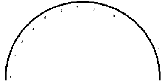
Vibrations from earthquakes slow down as they go through less dense material, so you collect data from your seismograph that shows how long it took the seismic waves from nine different quakes to pass through the planet to reach the machine. On the cross section diagram below, the locations of the earthquakes are numbered, and "S" marks the position of the seismograph. The data table will be used to fill in the results of your calculations. Now starts the fun.
Notes on
analogy presented in class:
- Use a metric ruler to measure the distances from each earthquake to the seismograph. Calculate the scale distance for this diagram from the first column that shows the straight-line distances through the planet. This is the distance that the vibrations had to travel to reach the seismograph from each earthquake. Show your calculation in question 1. On most printers this scale is around 904 km/cm
- Assume that seismic waves travel steadily at around 7.5km/sec through the colder, harder rock. Divide each distance by 7.5km/sec to complete column (2) with the wave travel times (TT). This is how long you can expect the waves to take to reach the seismograph from each earthquake if there is no hot soft rock in the way to slow them down.
- Compare column (2) with column (5), which shows how long it actually took for the waves to travel. If any of the actual travel times in column (5) are more than 10% higher than the predicted travel times for cold rock in column (2), then we can assume the vibrations from those earthquakes were slowed down as they went through an area of hot rock. We now need to find out how much hot rock there is. To do this, we will compare how much the waves were delayed on their actual trip with how much they would have been delayed if the entire distance was through hot rock. For the earthquake waves that were delayed, complete column (3) by dividing the distance from column (1) by the slower hot rock speed of 6.5 km/sec. Do not bother to do this for the earthquake waves with the same numbers in columns (2) and (5).
- Now complete column (4) by subtracting (2) from (3). This answer is how many seconds slower the waves would take if the whole route was hot. You will use this to compare with how delayed the waves really were so we can figure out how big the area of hot rock was.
- This column shows the actual, measured travel times for the vibrations from each quake to reach the seismograph.
- Complete column (6) by subtracting (2) from (5). This gives you how many seconds the waves were delayed by passing through hot rock.
- Complete column (7) by dividing (6) by (4) to get a decimal, then multiply by 100 to get a percentage. This percentage shows how much of the route from the quake to the seismograph was hot.
- Complete column (8) by applying the percentages in column (7) to the
distances in column (1). This is how thick the hot rock was along that line.
Check your answers below.
- Now you can start to map the size and location of the hot rock mass. Complete column (9) by dividing the distances in column (8) by the scale of the diagram that you calculated in step 1. This will tell you how long a line to draw on the diagram to represent the location of the hot rock along the path that the seismic waves took as they traveled to the seismograph.
- A seismologist studying the data from a seismograph directly over earthquake #1 reports no slowing of waves from quakes 1 through 7, and her calculations show 1472 km of hot rock between quake 8 and her seismograph, and 2670 km along the path of the waves from quake 9.
- Along the paths that had hot rock, draw a line to show the thickness of the hot rock. Connect the ends of those lines to complete your map of the hidden interior of the planet Earth.
An example is animated below.
QUESTIONS
- What is the scale distance of the paper (km/cm)? Show the calculation.
- Why do you not have to do any more calculations if your answer for the calculated high speed travel time in Column 2 is the same as the actual measured travel time in Column 5?
- Calculate the scale distances (the amount of soft
rock on the paper) for the seismic waves that travelled through soft rock to the seismograph directly over earthquake #1. Show your calculations here.
- What assumptions were made in order to simplify this exercise?
- Why would it be useful to use data from many more earthquakes and many more seismographs?
------------- DATA TABLE -----------
|
|
(1) |
(2) |
(3) |
(4) |
(5) |
(6) |
(7) |
(8) |
(9) |
|
Eq# |
Distance to seismo-graph |
TT at 7.5km/sec |
TT at 6.5 km/sec |
Difference of (3)-(2) |
Actual Measured Time |
Difference from (2) |
% of (4) |
Apply % to Distance |
Scale distance on paper |
|
1 |
12,021km |
|
|
|
1603sec |
|
|
|
|
|
2 |
11,384km |
|
|
|
1518sec |
|
|
|
|
|
3 |
10,838km |
|
|
|
1479sec |
|
|
|
|
|
4 |
10,118km |
1349sec |
1557sec |
208sec |
1401sec |
52sec |
25% |
2530km |
~2.8cm |
|
5 |
9,198km |
|
|
|
1283sec |
|
|
|
|
|
6 |
8,196km |
|
|
|
1130sec |
|
|
|
|
|
7 |
7,013km |
|
|
|
935sec |
|
|
|
|
|
8 |
5,920km |
|
|
|
789sec |
|
|
|
|
|
9 |
4,098km |
|
|
|
546sec |
|
|
|
|
Seismic Discovery Answer Check
Check your answers by filling in the blanks, then press "Enter" or "Return". Round your answers to the nearest whole kilometer. Problems? Try one km higher or lower.
The data from earthquake 1 indicates how many kilometers of hot rock?
The data from earthquake 2 indicates how many kilometers of hot rock?
The data from earthquake 3 indicates how many kilometers of hot rock?
The data from earthquake 4 indicates how many kilometers of hot rock?
The data from earthquake 5 indicates how many kilometers of hot rock?
The data from earthquake 6 indicates how many kilometers of hot rock?
The data from earthquake 7 indicates how many kilometers of hot rock?
The data from earthquake 8 indicates how many kilometers of hot rock?
The data from earthquake 9 indicates how many kilometers of hot rock?
 (Return to top of page)


 This page hosted by
  Get your own Free Home Page or by NetPlex


 (Return to top of page)


 This page hosted by