|
| LinkExchange Member | Free Home Pages at GeoCities |
|
| LinkExchange Member | Free Home Pages at GeoCities |


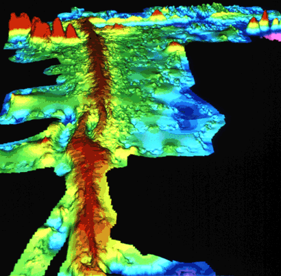
 The Mid-Atlantic Ridge

 A Tour Of Some Iceland Geology
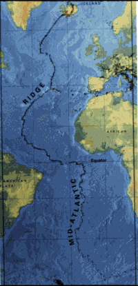 Plate Tectonics
The purposes behind the creation of this web-page were, of course, multi-dimensional. The information gathered here was born through a serious inquiry into the geological possibility that another island, much like Iceland, once existed somewhere along the Divergent Boundary of the Mid-Atlantic Ridge.

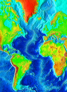
The Mid-Atlantic Ridge (MAR) stretches down nearly the entire length of the Atlantic Ocean sea-floor like the stitched-seam on a baseball. The MAR divergent boundary forms a continuous basaltic ridge between the Eurasian and North American continental plates in the North Atlantic, and the African and South American continental plates in the South Atlantic.
Map Of The Major Continental Plates
The global continental plates have all been interactively moving over 200 million years by means of a well established theory called Plate Tectonics. The roots of this modern geological theory were first set forth in 1912 by a German meteorologist and geophysicist, named Alfred Wegener, in his book THE ORIGIN OF CONTINENTS AND OCEANS.
Wegener’s then widely-ridiculed hypothesis, called Continental Drift, stated that all the continents of the world were once part of a supercontinent which he named Pangaea, meaning in Greek, “all land.” He established Paleogeological evidence, (ancient mountain structural belts,) on both sides of the Atlantic Ocean to support his theory.


 The Evolution of Continental Drift
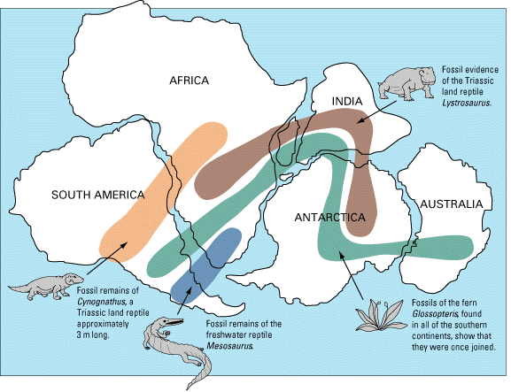
Wegener also established Paleoclimatological evidence (the study of ancient climates) through Paleozoic Glaciation studies linking south Africa, South America, India and Australia. Furthermore, he established significant Paleontological evidence with Mesosaurus fossils, (crocodile-like reptile fossils found in both southern Africa and South America,) and the trans-continental Paleobotonic presence of the fossil fern, Glossopteris, to further support his controversial theory. (See figure below)
 Gondwanaland Paleooceanography/Paleoclimatology
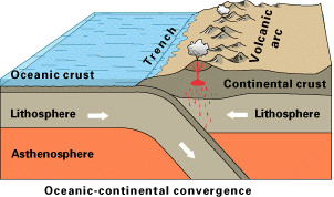
Today, it is widely accepted that over the immense passage of geological time, the fractured continents have all drifted to their present locations around the world. Although still not entirely understood, continental drift occurs through the combined processes of divergent boundaries (sea-floor spreading,) and Convergent Boundaries, (consumption of old sea-floor and Lithosphere back into the plasticized mantle,) and Transform Boundaries (continental plates sliding past each other without destroying underlying lithosphere,) and Hot Spots (hot-spot spread centers.)
Paleomagnetic fossil records of Geomagnetic Reversals, (periodic magnetic-field polarity reversals due to intensity changes in the Earth’s magnetic field,) have also played an important part in the processes of plate tectonics. Magnetic variations studied from core samples taken along the Reykjanes Ridge south-west of Iceland give evidence that basaltic lavas have been intermittently laid down along the Mid-Atlantic Ridge with both Normal Polarity (exhibiting the same magnetism as the present-day magnetic field) and Reverse Polarity (exhibiting the opposite magnetism as the present-day magnetic field.)
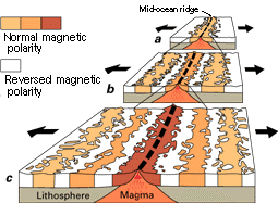 Magnetic Reversals
The study of MAR fossil magnetism is part of the science of Paleomagnetism. This magnetic fossil record would seem to suggest that the magnetic poles of Earth have oscillated polarity a significant number of times. Absolute dates have been applied to the Reykjanes Ridge magnetic variations to determine the spreading rate of the North Atlantic Ridge--which is about 1 to 2 centimeters per year. The rate is slightly faster for the South Atlantic.
Paleomagnetism Laboratory Geomagnetism & Paleomagnetism Home Page
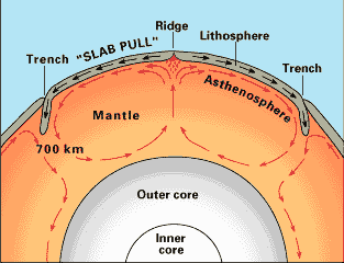
The dynamic driving mechanism behind spreading centers such as
MAR was first proposed by Harry Hess of Princeton University in the early 1960’s. His hypothesis, which was later termed Sea-Floor Spreading, states that the upwelling of mantle material from interacting Convection Currents deep within the plastecized mantle causes mantle material to penetrate the sea-floor lithosphere and create the production of new basaltic sea-floor along each side of a divergent boundary.
As new sea-floor pushes old sea-floor laterally away from the divergent boundary (spreading center) in opposite directions, old sea-floor meets deep trenches which mark convergent boundaries and push the underlying lithosphere under continental plates where it plasticizes and becomes part of the mantle again. This type of convergence is called a Subduction Zone, which keeps the amount of sea-floor nearly constant by laterally destroying the same amount which is being created.
Hess referred to this recycling action involving mantle convection cells, upwelling mantel material, sea-floor spreading, and convergent boundaries which replasticizes old sea-floor lithosphere, as a sea-floor “conveyor belt.” Of course, this "conveyor belt" moves quite slowly by our time standards. But on a geological time scale, new MAR sea-floor is being produced at an alarming rate--as much as 2-4cm per year along Slow-Spreading Atlantic divergent zones, and as much as 10cm along Fast-Spreading Pacific divergent zones.
Exactly how oscillating polarity reversals correlate to sea-floor spreading rates over the last 4 million years is still not entirely understood. Polarity reversals would seem to have a significant impact upon mantle convection cells, which are the power source for upwelling mantle materials. At any rate, MAR fossil magnetism core samples have allowed geologists to grasp hard geological evidence in support of the plate tectonic hypothesis by plotting their paleomagnetic time scale.
Another bit of compelling evidence that supports continental drift comes from matching mountain Structural Belts across the North Atlantic to the geological time when the Appalachian mountains of North America and the Atlas mountains of northern Africa created each other through interaction between the North American and African plates.
Likewise, the same Appalachian mountain belt runs up the North American plate to disappear off the coast of Newfoundland--only to reappear again in the inter-related mountains of Ireland and Scotland, and then again on the east coast of Greenland and the west coast of Norway, which are all part of the Eurasian continental plate. All of these mountain ranges are of aproximately the same geological age and composition.
When geologists match these structural belts by reversing the effects of continental drift, the jig-saw picture that is revealed depicts the adjoining land mass of the northern African, North American and Eurasian continental plates.
The single unifying factor that links them all geologically to one another is the ever-present MAR divergent boundary line.
Iceland falls on the map south-east of Greenland, but north-west of Great Britain. Its geological history presently seems unique to the Atlantic Ocean compared to the rest of the land masses discussed previously. Iceland is thought to be sitting upon what is referred to as a hot spot. The Pacific archipelago of Hawaii is the classic example of a Hot Spot/Island-Seamount Chain that stretches from Hawaii north-west to the Midway Islands, and then north to the Aleutian Trench.
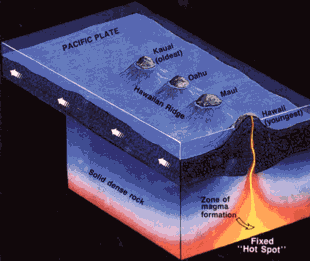
Hot spots are thought to be created by stationary Thermal Plumes rising deep from the Mantle-Core Boundary. These hot plumes, or hot spots, generally reveal themselves as volcanic structures which emerge from the ocean floor. As continental plates drift, hot spots are thought to remain stationary--thus creating archipelagos such as Hawaii. Little is known about exactly how hot spots interact with or drive the plate tectonic hypothesis. Most hot spots, about 20, have occurred along ridge systems like MAR. The Hawaiian Islands are unique in that they have no ridge system (spreading center.)
To put things into context--which brings to the foreground the reasoning behind creating this symposium--is it possible that Iceland is the only offspring landmass of the MAR hot spot? Iceland’s recent volcanic history has been highly volatile. Could a more-southerly located MAR volcanic-island previously have existed over the past, say, 100,000 years? Are there any possible locations along the MAR where another island, or archipelago, could have existed?
I would like to suggest that there may have existed two, possibly three, such locations along the MAR or its extreme proximity. As this symposium progresses, I will hesitantly devulge these possible locations--but as of yet, I am not entirely positive that the geological record will support them.
I am still not willing to extrapolate too far beyond the boundaries of the geological information I have presented. What may have possibly occurred on such a proposed "island" in the realm of human history is another matter altogether--and is not an area of my expertise. If the geological evidence stimulates speculation on someone else’s part--so be it. But don’t expect me to voice too many opinions concerning myths or legends without some basis of scientific proof.
After all, scientific proof in the form of solid geological evidence eventually gains the consensus of opinion. Consider the ground-breaking hypothesis’ of Wegener and Hess, if you think evidence is unimportant. Therefore, at the present time, I am somewhat of a coward to elude to the Lost Continent of Atlantis. However, the following link is the very best scientific analysis of the Atlantis "enigma" that I could find.
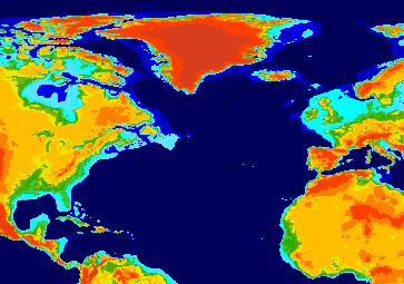
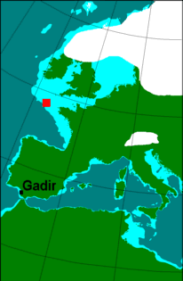
From a geological perpective, it is most interesting that the levels of the oceans rose 100 meters or more at the end of the last Glacial Age. You can see from the image below that much of the northern Eurasian Plate extending out from the British Isles (light blue) may well have been above sea level before the glaciers melted and retreated. This certainly would have made Iceland much larger than it is today--and as can be seen from the map, the possibility that another island ridge may have existed south of Iceland.
Atlantis: New Hypothesis
I have been afraid to deal with such a dangerous pseudo-historical cliché. One could probably fill the entire Atlantic Ocean with all the garbage which has been written about Atlantis. The very name "Atlantis" tends to spell doom for any serious geological hypothesis without any substantial scientific proof. On the other hand, a hypothesis is a "best guess" until further evidence can be proven or disproven. The real question is, can the MAR provide such evidence? My hypothesis is that the MAR divergent boundary (with or without the help of lower Ice Age sea levels) may have generated several islands during the evolution of the Atlantic Ocean's plate tectonic scenario.
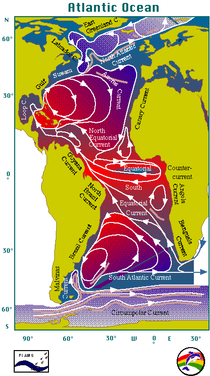
There is one final piece of evidence I want to consider before wrapping things up. What kind of climate would have prevailed over an island south of Iceland or the now inundated ancient-Eurasian-seashore? The British Isles are kept warm by the North Atlantic Current, even though the isles themselves are higher north in lattitude than Newfoundland. Satelite imagery has allowed us to peek at how ocean and atmospheric currents affect weather patterns. The following picture is a global heat satelite image.

This last picture shows the actual complexities of ocean currents. Note the North Atlantic Current, as well as the circular currents that make the Azores and Aleutian Islands almost tropical.
The definition for a symposium is: “to meet for the discussion of some topic.” I am prepared to post the most interesting questions, comments, answers or discussions that correlate in some way with the subject material presented. I will even consider some extreme speculations, as long as they do not "inundate" my original objectives. (Pun intended.) Let me hear from you.

Amazon.com is pleased to have "Orion Lion's Home Page" in the family of Amazon.com associates. We've agreed to ship books and provide customer service for orders we receive through special links on "Orion Lion's Home Page."
Amazon.com associates list selected books in an editorial context that helps you choose the right books. We encourage you to visit "Orion Lion's Home Page" often to see what new books he has selected for you.
Thank you for shopping with an Amazon.com associate.
Sincerely,
Jeff Bezos
President
Amazon.com
P.S. We guarantee you the same high level of customer service
you would receive at Amazon.com. If you have a question about an order you've placed, please don't hesitate to contact us.


 © 1997 conan07@msn.com