Return to Bluff Knoll 2002.
The Creator Triune God rules and cares. There are only 2 Ways to live.
On 31st December 2002, I enjoyed the opportunity to climb the highest peak#
of the Stirling* Ranges for the second time, this time with the excellent company of 9 others.
This was my 3rd climb in the Stirlings in the last 3 years, but my first with friends.
Expeditions I and II to Mt Toolbrunup (the 3rd highest peak in the Stirlings) were the first two.
Jon's Stirlings climbs so far;
1. 1983?-->Mt Trio; altitude of 856m...............2. 1986-->Bluff Knoll; altitude of 1073m...............
3. August 2000-->Mt Toolbrunup; altitude of 1052m......
4. April 2002-->Mt Toolbrunup...............
5. December 2002-->Bluff Knoll...............
6. January 2004 ->Bluff Knoll...............
7. December 2005->Bluff Knoll...........
8. October 2006--> Arrows Circuit hike I (Pyongerup,Ellen Peak, First Arrow all summited on this expedition) as part of my surprise bucks weekend with D and N....
9. October 2006--> Mt Trio II and Bluff Knoll V while on honeymoon with my wife Kathryn.
Many! thanks to friends from my Uni days for the opportunities in 2002,2004.
The drive into the Stirlings still had all the "magic" I remembered, with the dark outlines of the mountains exploding onto the horizon many km before reaching our final destination, and then looming up as great big shapes in between the trees near Amelup on the windy Chesters% Pass road.
The 10 of us set up tents that night at the Stirling Range Retreat,which I noticed still had the same swimming pool which I vaguely remembered from 1986.
The next day the weather for the climb was around 25-27 degrees which was warm, but not uncomfortable. With the cool breezes it was probably a bit cooler the closer we got to the summit. Quite pleasant. We managed to grab a few looks at the breathtaking views on the way up, and despite lots of water/lollies stops maintained a pretty steady pace all the way to the top. Towards the end of the climb things spread out a bit, but everyone made it to the summit in about 90-110min or so.
Ro and myself were first to get there, followed by Ma (the only one in the first 5 to avoid taking a wrong turn near the top), and then J and Ra.
See Ro's website for some excellent photos, and I know some of the others must have got some good photos too!
Saw an eagle on the wind currents at the top, and a few small lizards on the rocks.
Had a group photo on this ledge overlooking the 300m cliff face, (possibly the same area me and my brother Tim were looking over, more than 16 years ago, photos below).

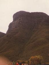

Photo on the far left is the view of Bluff Knoll from the carpark in 2002. The other two photos are from 1986.
Thanks to RC for the use of the 2002 photo.
Climbed down below this ledge a little this time, photo coming soon hopefully.
Don't think it was as windy on the top as it normally is.
I found the going down very hard, especially with all the steps, my right knee HATES! going down steps.
So ended up taking it easy with the two cousins, and we were last to descend the mountain.
Then it was off to the Bluff Knoll Cafe.
The "Dawn to Dusk" book by Rob and Stuart Olver, about the Stirling Ranges was great to have along.
Also saw one of the beautifully picturesque photographs (looking down at early morning cloud blanketing the ranges), taken by Rob Olver, on the wall at the Bluff Knoll Cafe where we had lunch afterwards. "Dawn to Dusk" is available at most operators in the Stirlings, and published by UWA press. I can arrange to get you a copy direct from one of the authors if you want to buy one.

Image Copyright 1998 Rob Olver and Stuart Olver. Used by Permission.This website describes "Dawn to Dusk" as;
A comprehensive and attractive guide to the Stirling and Porongurup Ranges. Includes stunning photo's, detailed maps and information about the parks.
Then I had the grind of a drive home to get to a New Years Eve gathering, but the happy memories of the climb,
the people, and most of all my time spent in one of the more beautiful parts of God's creation in Western Australia. :-).
Wish I could have stayed much longer in one of my favourite locations, with great company, but maybe next time.
Hope to do the "Ridge walk" some time in the next few years.....Perhaps with some of those who were part of our fired up group of 5 which bushwalked 37km of the Bibbulmun*** (which included an ascent of the 582m high Mt Cooke** with close to fullweight packs along the way) in just 2 days, starting from North Bannister in October 2002....or maybe someone else with the guts to do it.
*The Stirling Ranges were named after Governor James Stirling the first Governor of Western Australia.
**Mt Cooke is the highest point in the Darling Ranges which encompass much of the south eastern parts of Perth including Armadale, where I grew up. What we used to call the "gorge" is a valley with steep cliffs that runs from Wungong Dam near one of my old schools, (Emmaus aka Armadale Christian College), to South Western Highway on the way to Byford. On the map its called Wungong Gorge, and there is an old gravel airstrip landing area on the Byford side.
***"The Bibbulmun" were a tribe of Aboriginal people who were known to take long walks to get to their ceremonies.
#The highest mountain in Western Australia is 1245m high Mt Meharry.
Mt Meharry is in the Hamersley Ranges in the Pilbara Region near Tom Price, and not far from Port Hedland.
Chester is the surname of the first Police Officer stationed in the Stirlings area many years ago, who trailblazed a track, so as to get to Albany quicker on his frequent trips to HQ. Chesters Pass is now a roadtrain route, and also the main road to access the Stirlings.


L-R; Jon at Breakfast time before the climb, at the Stirling Range Retreat campsite,
Jon at the summit of Bluff Knoll.
Thanks to RC for the use of these photos.
The 5826ft "Round Bald", one of five peaks of Roan Mountain in TN, USA
which I visited in November 2001 is the highest point I have been to so far.

