Reloading with Roe Hwy 3hr 26 Ride!
Wednesday 19th April 2006; Cycled 50.5km in 3hr 26min on the mountainbike. HR 126. Time includes about 15minutes I spent on drinks breaks and checking my maps. Pretty solid long ride. Very happy with it. Plan is to do at least one ride like this per fortnight, (preferably each week) until my achilles allows me to run again. So this is WEEK 1 of my Perth Marathon 2006 Assault. Its an 11 week program same amount of time as what as I did in 2004. Its time to get really focused and ensure my long 3hour+ sessions get done preferably each week, plus do some shorter easy sessions, and some more intense sessions...
Hopefully the achilles will clear up well before July. Found a useful link from Cool Running re treating achilles problems, so did 4x16 calf raises (double legged) with 2 minute rests
today also. Made sure I stressed the eccentric phase (the lowering part) of each calf raise. Need to be disciplined about maintaining this. Also iced my achilles last night. Going to rest the calves (gastrocnemius and soleus muscles) tomorrow, and then plan to do my next bunch of calf raises on Friday.
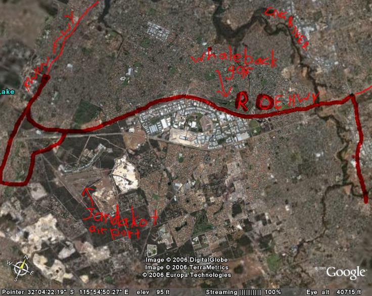
My ride was extremely interesting. Had heard that Roe Hwy now goes all the way to Kwinana Freeway, so was keen to see if this was true so followed Roe Hwy from Albany Hwy all the way to Kwinana Freeway, and then followed detour from Farrington Rd to Berrigan Rd, Karel Avenue and then back down Roe Hwy. Experienced lots of interesting sights,sounds and smells. The smell of a bakery in Canning Vale was good. Plenty of birds, plus the planes landing at Jandakot airport. Went past Whaleback and Glen Iris golf courses. My mountainbike is a bit worse for wear, but have to make do with what I have...it was ok...Had the usual niggling knee soreness at times, but mostly a very enjoyable and successful ride. Also came across some signs detailing the history of Aboriginal people on the plains below the Darling Scarp again, just as I did on Tonkin Hwy when I rode the 31km last week. Have learnt a few interesting things about how they lived in this area...Apparently they had 6 seasons for the year instead of our European influenced 4.
Seemed to cope better with saddle soreness this time, than I did on the Whiteman park 40km ride the other week. See how I pull up in the next few days. Onward and hopefully upward...
Hopefully the achilles will clear up well before July. Found a useful link from Cool Running re treating achilles problems, so did 4x16 calf raises (double legged) with 2 minute rests
today also. Made sure I stressed the eccentric phase (the lowering part) of each calf raise. Need to be disciplined about maintaining this. Also iced my achilles last night. Going to rest the calves (gastrocnemius and soleus muscles) tomorrow, and then plan to do my next bunch of calf raises on Friday.
My ride was extremely interesting. Had heard that Roe Hwy now goes all the way to Kwinana Freeway, so was keen to see if this was true so followed Roe Hwy from Albany Hwy all the way to Kwinana Freeway, and then followed detour from Farrington Rd to Berrigan Rd, Karel Avenue and then back down Roe Hwy. Experienced lots of interesting sights,sounds and smells. The smell of a bakery in Canning Vale was good. Plenty of birds, plus the planes landing at Jandakot airport. Went past Whaleback and Glen Iris golf courses. My mountainbike is a bit worse for wear, but have to make do with what I have...it was ok...Had the usual niggling knee soreness at times, but mostly a very enjoyable and successful ride. Also came across some signs detailing the history of Aboriginal people on the plains below the Darling Scarp again, just as I did on Tonkin Hwy when I rode the 31km last week. Have learnt a few interesting things about how they lived in this area...Apparently they had 6 seasons for the year instead of our European influenced 4.
Seemed to cope better with saddle soreness this time, than I did on the Whiteman park 40km ride the other week. See how I pull up in the next few days. Onward and hopefully upward...
