Distribution Maps of Inscribed and Painted Boulders of the Upper Midwest and North America
MINNESOTA Farmers in Minnesota often cleared agricultural fields of glacial erratics by drilling triangular holes and blowing them apart with dynamite. Farmers rock piles may reveal a wider distribution of the cup marked boulder phenomenon if a survey is made of these boulder remains, such as they are.
Newport, Minnesota
Click here for information regarding Minnesota's Sacred Red Rock boulder and Dakota religious beliefs related to boulders
or Spirit Island, Mille Lacs, MinnesotaDakota sacred painted boulders were historically reported at Shakopee, Lake Minnetonka, Eden Prairie, Birch Island Lake, Winona, St. Peter, and between South St. Paul and Mendota. Many of these were stolen or removed.
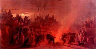
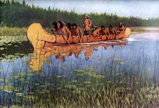
The Buffalo Dance
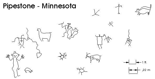
Pipestone, Minnesota
The "Three Maidens," the largest of several granite boulders near the Pipestone Quarry, (used to quarry Catlinite for pipes), rest upon red Sioux quartzite which were at one time covered with petroglyphs. The petroglyphs were cut out and removed in an effort to protect them by Charles H. Bennett, the "Father of Pipestone City." T. H. Lewis visited the Pipestone site and described it as follows:
There are 6 large granite boulders lying close together in the valley of Pipestone creek, east of south from the quarries, and west of south from the falls. The three largest are called the "Three Maidens," and they range in size from 60 to 65 feet in circumference and from 10 to 12 feet in height above the surface or the soil, but from the surface of the quartz upon which they rest they are from 12 to 14 feet in height. The smallest boulder is 89 feet in circumference and 4 ˝ feet high, There are no pictographs on the boulders as has been stated.
The Three Maidens rest on red quartzite, the colors of which range from dark red to light pink. The pictographs are carved on the quartzite, at and around the base of the 6 boulders mostly on the south side, but there were a few an the North side and on the quartz slopes slightly at various angles, and there are numerous seams or cracks that divide the surface into small slabs of various sizes with irregular outlines.
The pictographs are of three classes,1st those made with some round pointed implement,
2nd those made by hacking or cutting, as with a narrow bitted chisel,
3rd Those that were first picked or cut out, and there smoothly polished,The latter are apparently the oldest, and they are much harder to trace, and made doubly so, by other carved lines covering or overlapping them.
It is impossible to determine the date of any of them for in some instances a part of a figure appears very
ancient, and other portions seem to be of a more recent date, but a careful examination with a glass, of the work in both parts shows it to be one and the same. The overlapping and intermingling of the figures would not necessarily mean that they were of different dates, nor would difference in workmanship indicate it, for the figures may have been placed there on the same day by different individuals.
George Catlin in Letters and Notes on the Manners, Customs, and Condition of the North American Indians (1844) London: David Bogue wrote about the petroglyphs he saw being made at Pipestone:
I have been unable to find anything like a system of hieroglyphic writing amongst them; yet, their picture writings on the rocks, and on their robes, approach somewhat towards it. Of the former, I have seen a vast many in the course of my travels; and I have satisfied myself that they are generally the totems (symbolic names) merely, of Indians who have visited those places, and from a similar feeling of vanity that everywhere belongs to man much alike, have been in the habit of recording their names or symbols, such as birds, beasts, or reptiles; by which each family, and each individual, is generally known, as white men are in the habit of recording their names at watering places, &c.
Many of these have recently been ascribed to the North-men, who probably discovered this country at an early period, and have been extinguished by the savage tribes. 1 might have subscribed to such a theory, had 1 not at the Red Pipe Stone Quarry, where there are a vast number of these inscriptions cut in the solid rock, and at other places also, seen the Indian at work, recording his totem amongst those of more ancient dates; which convinced me that they had been progressively made, at different ages, and without any system that could be called hieroglyphic writing.
The paintings on their robes are in many cases exceedingly curious, and generally represent the exploits of their military lives, which they are proud of recording in this way and exhibiting on their backs as they walk (Catlin 1844: 246).A look at the petroglyphs at Pipestone, however, indicates many petroglyphs that show shamanistic heartlines, thunderbirds, horned turtles, etc. which suggests that Catlin may not have appreciated the difference between a Native American recording his dream symbol (representing his vision or secret dream name) and the recording of a totemic or a secular common "name." This would suggest his attribution of motivations solely to vanity instead of a religious sentiment may have been somewhat ethnocentric and overly simplistic. There also appear to be some inaccuracies in his painting of the Pipestone Quarry such as the relative size of the cliff and the position of the Three Maidens.
Brown's Valley, Minnesota
Theodore H. Lewis (1883) described an inscribed granite boulder called "Sacred Rock" at Browns Valley, Minnesota "located in the edge of the public park on the north end of the plateau, which is about 40 feet above the Minnesota River. The boulder has a flat surface, with a western exposure, and is about 5 feet 8 inches in diameter, irregular in outline, and firmly embedded in the terrace." The inscribed granite boulder had petroglyphs that he said represented a man, bird, tortoise, bird tracks, dots or cups cut into the the rock and "a cross and circle combined . . . probably . . . an unfinished tortoise." He reported that: "The name 'Sacred Rock' has no significance as regards the markings, for two lovers named the boulder without knowing that there were pictographs upon it. The grooves are about 1/8 of an inch in depth in a granite boulder."
Sacred Rock sits outside the Brown House in a city park on a cement slab but little is visible today except two perpendicular straight lines.
NORTH DAKOTA Fort Ransom, North Dakota
In addition to the Fort Ransom Writing Rock in eastern North Dakota there are many other cup marked granite boulders in the area near Fort Ransom. Cup marks are also sometimes refered to as "pit and grooves," or "cupules" in North American archaeological literature. T.H. Lewis (1891) reported thirteen incised boulders of various sizes within four hundred feet of the Fort Ransom spring, one of which was the Fort Ransom Writing Rock. These artifacts are on private property and are protected by the local landowners, the local community, and some very nasty plants. My last visit necessitated medical care for a reaction that lasted about three weeks.
The Hidatsa Medicine Stone, Lewis and Clark, and Maximilian, Prince of Wied's Travels in the Interior of North America.
Maximilian, Prince of Wied (1906:339-40) in Travels in the Interior of North America Arthur H. Clark Company: Cleveland, described the Hidatsa Medicine stone and other nearby medicine (vision quest) locations as follows:
Another curiosity of a similar nature is the Medicine Stone, which is mentioned by Lewis and Clarke, and which the Manitaries likewise reverence. This stone is between two and three days' journey from the villages on Cannon-ball River, and about 100 paces from its banks. I was assured that it was on a tolerably high hill, and in the form of a flat slab, probably of sandstone. The stone is described as being marked with impressions of the footsteps of men, and animals of various descriptions, also of sledges with dogs. The Indians use this stone as an oracle, and make offerings of value to it, such as kettles, blankets, cloth, guns, knives, hatchets, medicine pipes, &c., which are found deposited close to it. The war parties of both nations, when they take the field, generally go to this place, and consult the oracle as to the issue of their enterprise. Lamenting and howling, they approach the hill, smoke their medicine pipes, and pass the night near the spot. On the following morning they copy the figures on the stone upon a piece of parchment or skin, which they take to the sage, where the old men give the interpretations. New figures are undoubtedly drawn from time to time on this stone, near to which the celebrated ark, in which part of the nation was saved in the great deluge, formerly stood.
The Mandans have many other medicine establishments in the vicinity of their villages, all of which are dedicated to the superior powers. Mr. Bodmer has made very accurate drawings of those near Mih-Tutta-Hang-Kush, one of which consists of four poles placed in the form of a square; the two foremost have a heap of earth and green turf thrown up round them, and four buffalo skulls laid in a line between them, while twenty-six human skulls are placed in a row from one of the stakes at the back to the other; some of these skulls are painted with a red stripe. Behind the whole a couple of knives are stuck into the ground, and a bundle of twigs is fastened at the top of the poles with a kind of comb, or the teeth of a rake, painted red. The Indians repair to such places when they desire to make offerings or put up petitions; they howl, lament, and make loud entreaties, often for many days together, to the lord of life, which the French Canadians call weeping, though no tears are shed. A similar medicine establishment is represented, where a couple of human figures, very clumsily made of skins, . . . were fixed upon poles, representing, as we were told, the sun and moon, probably the lord of life and the old woman who never dies. Wormwood, of which they generally fasten a bunch to the poles, is a sacred medicine herb, to which they ascribe various effects.
Dreams, as I have before said, afford the usual motives for such actions, and for the penances which they impose upon themselves, and they believe all that appears . . .The Original Journals of the Lewis and Clark Expedition 1804-1806, ed. Reuben Gold Thwaites, (1904) Dodd, Mead & Company, New York p. 264 indicates (exactly as written):
21st February Thursday 1805
a Delightfull Day put out our Clothes to Sun. Visited by the big White & Big Man they informed me that Several men of their nation was gone to Consult their Medison Stone about 3 day march to the South West to know what was to be the result of the ensuing year. They have great confidence in this stone, and say that it informs them of every thing which is to happen, & visit it everry Spring & Sometimes in the Summer. "They haveing arrived at the Stone give it -smoke and proceed to the Wood at Some distance to Sleep the next morning return to the Stone, and find marks white & raised on the stone representing the peece or War which they are to meet with, and other changes, which they are to meet" This Stone has a leavel Surface of about so feet in Surcumfrance, thick-and porus," and no doubt has Some mineral quallites effected by the Sun.'
The Big Bellies have a Stone to which they ascribe nearly the Same Virtues
Capt Lewis returned with 2 Slays loaded with meat, after finding that he could not overtake the Soues War party, (who had in their way distroyed all the meat at one Deposit which I had made & Burnt the Lodges) deturmined to proceed on to the lower Deposit which he found had not been observed by the Soues he hunted two day Killed 36 Deer & 14 Elk, Several of them so meager, that thev were unfit for use, the meet which he killed and that in the lower Deposit amounting to about 3000lb was brought up on two Slays one Drawn by 16 men had about 2400 lb on it_________________________
1 See descriptions of this "medicine stone," and of the ceremonies with which the Indians invoked the spirit supposed to dwell there, in Long's Expedition, i, pp.273, 274 and Maximilian's Voyage, ii, pp. 459, 460. Both the Mandan and Minitaree were accustomed to consult these oracles ; Matthews says of the latter (Ethnog. Hidatsa, p. 51) : " The Hidatsa now seldom refer to it, and I do not think they ever visit it." -Ed.
The Medicine Rocks are on a high point on private property and it is an active religious site for the Lakota who visit it regularly.
SOUTH DAKOTA Robert's County, South Dakota
T.H. Lewis (1883) described an inscribed granite boulder called "Thunder Bird's Track" in Robert's County, South Dakota "on the summit of a hill, which commands a good view of the country, but there are other hills in the vicinity that are higher. The boulder is about 3 1/2 feet in diameter, and well bedded into the hill, and the characters are grooved into the surface about 1/4 of an inch in depth, and are for the most part very smooth." The petroglyphs include two hands in combination, a nondescript, a nondescript, though a portion of it represents a hand and two figures that "are undoubtedly hands, as their outlines can be imitated in shadow upon the wall by placing on'e own hands in the proper positions."
Lewis reported the "Dakota tradition regarding Thunder Bird's Track" as follows: "Thunder Bird is said to have had his nest on a high mound, which was composed of sticks and brush, and was situated some 10 miles north-west of the foot of Lake Travers in the center of a deep wide gorge. One day there was a great storm which flooded the whole country. Thunder Bird, in his anger at having been driven from his nest by the rising waters, flew away and alighted on this rock - Wakiyan Oye - which was the only place not covered by water and left the impression of his feet there. Note. This tradition was apparently gotten up by the Indians to account for the characters on the rock and is given for what it is worth. Aug. 26th, 1883."
Lewis reported that: "On the summit of the hill on which Thunder Bird's Track is located there are six (6) other boulders on which there has been more or less work done. The pictographs on four of these boulders were copied. The two boulders not copied each had a ring cut on the face which was about 2 1/2 inches in diameter - inside measurement and 1/2 of an inch in width." The boulders had petroglyphs of human hands, cups, and "probably bird tracks." "According to Lewis: "All these rocks are within a space of 25 feet square" and the face of Rock No. 2 "is 3 1/2 x 4 1/2 feet in diameter. The grooves are from 1/4 to 1/8 of an inch in depth. They were first pecked out and then rubbed smooth." In describing Rock No. 5 he indicated that: "These pictographs are merely [pecked] out, but those on Rocks No. 3 and 4 are smooth." The face of Rocks No. 3 and 4 are described as only 10 x 13 inches in diameter.
Thunder Bird's Track's Brother "is situated on the slope of a terrace bordering the Minnesota River and about 2 miles east of Thunder Bird's Track. . . .The Indians give no reason why they call these pictographs a brother to those on the Thunder Bird's Track rock. Aug. 26th, 1883." The boulder apparently has "bird's tracks" a figure "like a letter R reversed," a hand similar to one found on Thunder Bird's Track, and nondescripts.
Another boulder near Thunder Bird's Track's Brother "is on the same slope and is about 12 x 20 inches in size" and had the figure of a birds claw and 2 nondescripts.
A fourth inscribed boulder "is situated about 1 1/2 miles south of Travers City, and is about 4 x 4 feet in diameter. The face is 2 x 2 1/2 feet in diameter" and had tortoises, probably a bird track, a man similar to the one at Browns Valley, a nondescript and a figure that "probably represents a bird with wings spread out. The figures are 1/4 of an inch in depth and very smooth. July 9th, 1886."
A fifth inscribed granite boulder with "grooves 1/4 of of an inch in depth" was located "south of Thunder Bird's Track's Brother about 100 yards, and is near the bottom of the slope of the terrace. The face is about 1 1/2 x 2 1/2 feet in diameter." The figures include a "thombles" (thumbless?) hand, what may be an unfinished tortoise, a nondescript, 4 probable birds tracks and a nondescript animal. Lewis made note of these on September 13th, 1887.
Some of the Thunder Bird Tracks petroglyphs described by T.H. Lewis still exist and are visible and are on private property in South Dakota and well protected.
MONTANA The Medicine Rock of Malta
NEBRASKA Cedar County, Nebraska
Lewis describes the Cedar County inscribed granite boulder as follows: "The boulder is of granite 4 x 4 feet in diameter and protrudes out of the ground about 2 feet. Its total thickness is about 2 1/2 feet. It is on top of a hill about 150 feet above the valley. The figures are as follows: . . . 14 bird tracks, . . . 12 nondescripts, . . . animal's horns, . . . a cup, . . . pin shaped, . . . human hand? . . . human foot. The grooves are from 1/8 to 1/2 an inch in depth and they were picked out and rubbed smooth. There are other (uncopied) grooves on the rock and which are very dim and much the oldest. Sept. 15th, 1890."
COUNTY BOULDER SPARKS SCIENTIFIC DEBATE By Edward Roger Tryon Cedar County's famous petroglyph boulder was unquestionably a "drift pebble" or "glacial erratic" deposited by one of the great ice sheets that moved down from the north more than 10,000 years ago. Then, when the earth entered an early phase of "global warming," the ice melted and the boulders were dropped. In Cedar County many glacial boulders are found north of 877 Road. In a Cedar County News article dated July 14, 1921, Elmer Blackman, then Curator of the State Museum, told of investigating the site where the petroglyph boulder had rested until 1892. The location was described as being on the "high point of a hill where there were too many rocks for cultivation." Blackman noted that the petroglyphs first had been picked into the hard granite surface with some type of tool. The indentations were then polished to a smooth U-shaped groove. According to Blackman, the smoothing process would have required large quantities of quartz sand. But after sifting and washing the earth from the area surrounding the place where the boulder had been removed, Blackman found no evidence either of tool fragments or particles of the sand used in the smoothing process. Blackman also inspected other rocks in the vicinity but found none containing markings of any kind. "If Indians had cut these characters," he said, "it is certain that some more promising rock near would have received at least a trial of the same tools." According to Blackman, the Cedar County boulder was unique. None like it had ever been found in Nebraska. In fact the only other petroglyphs found within the boundaries of the state were at a place called Indian Cave north of Falls City. The Indian Cave glyphs depict recognizable animal forms. The Cedar County petroglyphs, on the other hand, are mainly abstract symbols with no discernable meaning. Blackman checked with representatives of the various tribes known to have inhabited Nebraska in historic times. None of these tribes had any knowledge of the Cedar County rock nor could they translate the symbols carved thereon. From his knowledge of erosion rates, Blackman deduced that the rock would have been completely buried before 1669. This, he said, would eliminate the region's more ancient inhabitants as authors of the strange writing. After considering all known possibilities, Blackman concluded that the boulder must have been carved before the glacier brought it to Nebraska. "This puts us in deep water," he remarked, "because science does not recognize man before the drift in America." Blackman's conclusion shocked the scientific community. For if his thesis was correct -- that the petroglyphs had been carved before the glacier deposited. the boulder on a hilltop in Cedar County -- the long-held theory that the first humans in North America had arrived no more than 13,000 years ago would have to be discarded. Blackman's theory has neither been proven nor disproven. However, there is reason to suspect he may have investigated the wrong site in 1906. In the Cedar County News article cited above, Blackman gave the location as the Northeast Quarter of Section Nine, Township 30, Range 1 East. This legal description would place the boulder two miles west of Hartington on Highway 84 and one mile south on 561 Avenue (north of the substation). Hartington site: Rocks but not on the hill Another article which appeared in the Cedar County News of August 4, 1927, stated that Blackman had recently returned to Cedar County and photographed the site. The article noted that "a large pine grove now covers the hills once rough with rock." Still another News article dated July 21, 1927, indicated the rock was found on the John Post farm near Coleridge. That location is five or six miles southeast of the Hartington site. "I was told the rock came from my pasture," said Velma Nordby, a resident of the Embers in Coleridge. Mrs. Nordby, who is related to John Post, directed this writer to a place known as "Evergreen Hill." The location, once part of the Post farm, is one mile north of Coleridge on Highway 57 and a mile and a half west on 877 Road (which does not go through from the highway). The land in the vicinity of this lofty hill contains many rocks and a few red granite boulders. Evergreen Hill near Coleridge The Hartington site also contains rocks and boulders but none are found on the high point of a hill, as described by Blackman, nor is there any indication that this property was ever covered with pine trees. The discrepancy may have been resolved when the writer purchased a copy of Samuel Aughey's book on the Internet. On page 256, Aughey clearly states that the boulder was found near the quarter-section stone, between Sections 25 and 36, in Township 30 North, Range 1 East. That description would place the boulder roughly in the middle of 877 Road north of the existing grove of evergreens. The property on the south side of the road is now owned by Larry Rathgeber; the property on the north belongs to Ken Mitchell. But finding the rock's location does not resolve the question of when the petroglyphs were carved or by whom. Stranger things -- including frozen mammoth remains -- have been preserved in glacial ice. On the other hand, at least two modern authorities believe the petroglyphs were most likely carved after the glacier brought the rock to Cedar County. "In my experience in the [glacial] tills of Northeast Nebraska ... I am certain that the boulder was in place in Cedar County when it was actually carved," said George Corner of Lincoln. Mr. Corner, who is Collection Manager for the Division of Vertebrate Paleontology, University of Nebraska State Museum, provided some of the information used in this article. Kevin Callahan of the University of Minnesota, who has authored a book on the petroglyphs found near Jeffers, Minnesota, also believes the inscriptions were most likely carved on site. In an e-mail to this writer, Callahan stated: "The symbols and motifs on the boulder are very familiar ones. The footprint and turkey track motifs are found all over North America. The number of Thunderbird symbols indicates this was a very important stone." Callahan suggested that the boulder may have been used by medicine men who dreamed of the "upper world" or possibly marked a place where Native Americans prayed before hunting or going to war. "Boulders like this are found in western Minnesota and eastern South Dakota; that area was considered the home of the Thunderbird." Still, the carvings could be quite old, he said. Whether it is a pre-glacial relic or a sacred stone to more recent Native Americans, Cedar County's petroglyph boulder does not appear to be one of the State Museum's more highly-prized artifacts. After nearly being carted off to a landfill in 1968, the boulder, which once attracted "scientists from all over the civilized world," has been consigned to a picnic area in front of Morrill Hall. Next time you visit the fossilized elephants therein, pause to look at Cedar County's remarkable relic before the inscriptions are erased by the feet and fannies of countless middle-school field trippers. "Pages of History" by Edward Roger Tryon Laurel (NE) Advocate May 26, 2005
MISSOURI Carol Diaz-Granados at the Department of Anthropology, Washington University reported cup marks at almost all of the sites in the southeast quadrant of Missouri. The most impressive cup marks are those at the entrance of Bushnell’s Ceremonial Cave. Illustrations of Missouri cup marks can be found in Dr. Diaz-Granados Ph.D. dissertation. Dr. Diaz-Granados has recorded approximately 50 new petroglyph and pictographs bringing the number of rock graphic sites in Missouri to at least 134 including a site with a possible segment of the Siouan "Red Horn" myth in red, black, and white pigment.
IOWA Blood Run, Iowa
Dale R. Henning (1982) described six pitted stones at the Blood Run site in northeastern Iowa which included a large Sioux quartzite boulder approximately 3 by 4 feet. He reported that: "This boulder bears small conical depressions over its entire surface; these appear to have been made mechanically and consistently measure 2-4 cm. in breadth and 1-3 cm. in depth. The largest of these stones is that located by Orr; the others are smaller, but none are portable by any means. According to local informants, a pitted boulder similar to the largest one we located was removed by dint of considerable effort by a local collector from the Sioux Falls area. All of these boulders, located along the terrace edge, and of course, including the one currently residing near Sioux City, were probably removed from their original location(s) when the fields were being cleared for agricultural purposes."
WISCONSIN Hmmm....
SASKATCHEWAN A.P. Buchner presented a paper at the 1994 International Rock Art Congress in Flagstaff, Arizona regarding an excavation he and Jack Steinbring undertook at the base of a cup marked boulder in Saskatchewan that yielded artifacts, additional buried rock art, and radiocarbon dates. The abstract for the paper indicated that "Carved monoliths in Saskatchewan appear related to those of eastern Alberta where excavations give a possible late Paleo-Indian provenience at one site. A carved monolith at the Herschel site in Saskatchewan yielded clear evidence of shrine use, with numerous offerings over at least 1,500 years. At a carved monolith near Swift Current, Saskatchewan, a panel of black rock paintings has been excavated over two field seasons. The paintings appear related to the late Northern Plains incised petroglyph tradition while petroglyphs at this site strongly resemble those of Archaic petroglyph sites in the eastern Woodlands. A small "ritual zone" containing pigments, delicate pecking instruments, and staining directly contacts one rock painting at Swift Current" (IRAC Program 1994).
ONTARIO There are some references to possible petroforms made of boulders in Ontario . on the WWW.
EASTERN UNITED STATES Cup marked stones were reported by Squier and Davis (1847) in "Ancient Monuments of the Mississippi Valley" p. 206 (a cupmarked 30 - 40 lbs. sandstone block found in a mound), by Charles Rau (1881) in "Observations on Cup-Shaped and Other Lapidarian Sculptures in the Old World and America" In "Contributions to North American Ethnology" Vol. V., Washington 1882, by Daniel Wilson in "Prehistoric Man" 3rd ed. 1876, Vol. I.) and by T.H. Lewis (1891:456-457) in The American Naturalist article "Cup-Stones Near Old Fort Ransom." Cupmarked stones were found in Illinois, and Connecticut. A cupmarked sandstone block was reported in Lawrence County, Ohio, below Cincinnatti, a second cupmarked sandstone boulder was found near Tronton [Ironton], Ohio and also elsewhere to the east including a site at Bald Friar Rock in the Susquehanna River, Cecil County, Maryland, and the "incised rock" in Forsyth County, Georgia.
FAR WEST E. Breck Parkman, District Archaeologist, California Department of Parks and Recreation, Silverado District, has described in several articles numerous cup marked boulders found in the far West, Canada, and South America. His papers include such articles as "A Theoretical Consideration of the Pitted Boulder, " "Pit-and-groove antiquity in New World Prehistory," "Creating Thunder: The Western Rain-Making Process," "California Dreamin': Cupule Petroglyph Occurences in the American West," "The Canadian Ribstone Petroglyphs," and "Lungumari Puntilla: A Cupule Petroglyph Occurrence On The South Coast Of Peru."
SIBERIA AND ELSEWHERE Pitted boulders occur throughout North America. They are known to occur in Alaska, Alberta, and Saskatchewan, the Northwest Coast, Siberia, northern Mexico, and South America (Parkman 1994 ms "Pit-and-Groove Antiquity in New World Prehistory"). Cupules occur throughtout the world in Europe, India, Australia, and across the Pacific Islands (See e.g. Breck Parkman 1994; Georgia Lee; and the Jinmium, Australia discovery)
Dakota religion and sacred boulders
WE NEED YOUR HELP
Anyone with information regarding the location of unreported cup marked or inscribed boulders or fragments thereof is urged to contact UMRARA. UMRARA would like to compile a more complete distribution map of this cultural phenomena for this region.
Contact: Kevin L. Callahan,call0031@tc.umn.edu, Charlie Bailey,cbailey@pclink.com or Deborah Morse Kahndeborah@pclink.com
Distribution Maps of Inscribed and Painted Boulders of the Upper Midwest and North America
This page hosted by Get your own Free Home Page