Court House Excavations, Kempsey, Worcestershire

January 1956
By Helen E. O'Neil, F.S.A.

(This site is about the history of the village of Kempsey, Worcestershire, England. This page is a transcript of the report on an archaeological dig near the church.)

Pre-Roman Roman Dark Ages Domesday Book Medieval Civil War Industrial
Revolution
Victorian Modern Timeline

Home What's New A-Z Index People Index Links Genealogy Church Maps Site Search Sources
      

A small area comprising the north-west angle of the earthwork at Kempsey, 1 including part of the former garden of Court House, was available for excavation prior to the sale of the land for private building. The Inspectorate of Ancient Monuments of the Ministry of Works undertook the excavation with the permission of the Rural District Council of Upton-upon-Severn, the owners of the property. The writer was invited by the Inspectorate to supervise the work, which consisted of trial trenches dug during two weeks in January 1956.


The Rural District Council are thanked for their permission to excavate and for the facilities kindly arranged by them for entering the site. The writer is also grateful for help from Miss Sarnia Butcher, of the Inspectorate of Ancient Monuments, Mr. L. Richardson, Mr. G. C. Dunning, Mr. Graham Webster, Dr. J. K. S. St. Joseph, Mr. A. H. Oswald and Mr. R.P. Wright. To the Vicar of Kempsey, the Rev. H. M. Glasgow and other local celebrities reaching octogenarian and nonagenarian ages who supplied useful and important information and to the Rev. D. Pocock for permitting the Kempsey MS2 compiled by the late R. C. Purton to be examined in the Cathedral Library, grateful thanks are extended.

The interest paid to Kempsey by archæologists in the past has been to the so-called camp, standing near the River Severn, west of the present day village and within which stands the Church, the Court House3 and some other houses. It will be seen from the following remarks that the slight and irregular nature of the earthwork makes it unlikely to be of Roman construction, although Roman remains have been found in the near vicinity. Such being the writer's opinion she will continue to call it an earthwork rather than a camp.

Notes
1. 6" O.S. Worcs. XL S.E.
2. Collections for a History of Kempsey. Rev.R. C. Purton, 1899
3. The Manor House, later the Parsonage Farmhouse, now the Court House, became the Vicarage when the old Vicarage was purchased by Robert Nuttall, Esq. in 1875. The old Vicarage was then demolished when the site became part of the flower garden of Kempsey House. It stood just across Hatfield Brook east of the Church. There is a sketch of it in Rev. Purton's MS. The present Vicarage is a charming regency House some half mile distant on the Upton-upon-Severn Road. See also Historical Notes relating to the Parish of Kempsey, by the Rev. R. C. Purton in Worcester Architectural and Archaeological Society, Vol. XXV, p.592. (1899-1900).


Page 34

The earthwork stands on a natural terrace of gravel,1 on the east bank of the River Severn formed between that river and a small tributary, the Hatfield Brook. The gravel terrace, which rises gradually northwards from its start at the confluence of the rivers, lies some 50-70 yards from the Severn and stands from 10 to 14 feet above the floodplain. The latter, further north, spreads out into a much wider area called the Upper Ham. During floods the water reaches the base of the terrace and augmented by the Hatfield Brook surrounds the earthwork on all sides except the north.2. It is only here that an artificial bank has been constructed and a ditch dug across the gravel terrace, the rest of the earthwork being formed by the scarping of the natural banks of the terrace. There is, however, a slight bank 3 on the south side of the Churchyard, which formed, until a recent extension, the southern boundary of the Churchyard. The earthwork, then, being constructed on a natural deposit of gravel between two rivers and only needing an artificially-made defence on the line of approach i.e. from the north, may be considered a type of promontory enclosure, suggesting an earlier form of earthwork than that of one of the Roman period.

Jabez Allies in his Antiquities of Worcestershire 4 (1840) appears to be the first antiquarian to collect information and describe Roman finds from Kempsey and all subsequent information has been based on his work. He describes the extent of the earthwork, as he is distressed at the destruction of parts of it by gravel digging in his day. "Great alterations being occasionally made at the site of the Kempsey camp, I will endeavour to give an account of it, as it appeared in 1840, fearing that in a few more years every vestige of it will have passed away. The western agger lay on the ridge of ground, or precipice, skirting the flat on the east side of the Severn. The north end of it commenced at the back of the garden belonging to the Parsonage farm-house, and ran in a line from thence to within about fifteen

Notes
1. Known as Worcester Terrace.
2. The situation is thus virtually an island, hence Kempsey. Cymi's island. E. Ekwall. The Oxford Dictionary of English Place-Names, p. 258. Flooding is still prevalent and in recent years boating to the grocers for supplies has been necessary. The Rev. R. C. Purton writing of the old vicarage as being a small and incommodious residence says that "in time of flood the good vicar was forced to embark for his Church in a boat from the window".
3. The bank is a slight work but is at least older that 1688 as the remains of venerable elm trees planted to commemorate the "Revolution', the accession of William and Mary, still grow on the bank. The opportunity also occurred, during the the present excavation, to observe the fillings from the area of the presumed line of ditch outside the bank, due to a burial. this consisted entirely of the natural red marl of the district.
4.The Ancient British, Roman, and Saxon Antiquities and Folk-Lore of Worcestershire. Jabez Allies F.S.A. 1840


Page 35

yards of the south-west corner of Kempsey churchyard, where it turned round. Judging from a measure I made by foot-steps, this agger was about two hundred yards long. The southern agger appears to have run along the south side of the churchyard, and was about ninety yards long. The eastern agger ran along the east side of the churchyard and other property, and through the garden of Gore Cottage,1 and into the orchard behind, and was about two hundred

Notes
1. Now the Cobbler's Cottage


Figure 1: Map of the Location of the Excavations

Fig. 1


Page 36

yards long. The northern agger ran from the above-mentioned garden and orchard to the north-west corner of the garden of the Parsonage farm-house, and was one hundred and eighty yards long or thereabouts. The rounded corner which lay in the garden was very perfect, until the latter end of the year 1863, when it was removed; but the portion of the agger which lies in the orchard still remains entire, and measures twenty-six yards in width."

In addition to the destruction caused by gravel digging mentioned above, a sketch map1 of the earthwork in the Purton MS shows the area along the east side, now a paddock between the Church and "The Rookery", as "worked for Gravel" and the north-east corner as "demolished 1836". A present sketch map (Fig. 1.) marks with hatching, those areas removed by gravel digging but with the destroyed line of the earthwork superimposed. Haverfield, writing on Roman Remains in Worcestershire for V.C.H.2 referring to the Kempsey earthwork in a footnote says: "As a matter of fact the earthworks seem to have been faint as long ago as Aubrey's day. (MS 14, p.180 in the Bodleian)." The removal of gravel from the paddock on the eastern side of the earthwork, as mentioned above, has created the false impression that the Church and Churchyard stand within a square enclosure. Alterations hereabouts too, have been caused by the construction of an ornamental pond in the bed of the Hatfield Brook for the garden of Kempsey House.

The Roman finds at Kempsey consisting of pottery, brooches, bones and a coin of Nero are described by Jabez Allies as coming from burial cists dug out of gravel beds at Kempsey in 1835 and 1836. He says "The spot in question is situated about four miles from Worcester, in a ploughed field called the Moors,3 which belonged to the late Joseph Smith, Esq., on a ridge or precipice of ground, out of flood's-way, which skirts the flat on the east side of the River Severn, and lies between that river and the village of Kempsey, near the northern side of the mound or agger of a Roman camp, within the site of the southern end of which Kempsey Church stands". The area so described as the site of the Roman finds, lying to the north of the northern agger of the earthwork, must therefore be the land utilized as an extensive market garden some 100 yards away.
Roman pottery found (A.D. 1835-1836) is marked on the 1887 Map of Kempsey. Search the Old Maps site for Kempsey, then zoom in or click the 'Enlarged View' button.
This point is stressed as the site marked on the 25" OS map as "Roman pottery found (A.D. 1835-1836)" is wrongly placed, since this spot was actually on the north-west angle of the earthwork and could never have been a ploughed field.

Excavations have already been carried out on the earthwork in an attempt to date it, by Dr. J. K. S. St. Joseph in 1935 and Mr. Graham

Notes
1. There is also a map of the earthwork surveyed by H.H. Lines in the Guildhall Library at Worcester but the writer was unable to consult it.
2. Victoria History of the County of Worcestershire, Vol. I, p.210
3. The area called the Moors cannot now be traced.


Page 37

Webster in 1953. Dr. St. Joseph 1 cut a trench through that portion remaining of the northern rampart in the orchard behind the Rookery but found no useful evidence, while Mr. Webster 2 dug a trench on the west side of the earthwork adjoining the western boundary of the Churchyard.
The Bishop's Palace is marked on the 1887 Map of Kempsey. Search the Old Maps site for Kempsey, then zoom in or click the 'Enlarged View' button.
The area selected by him for excavation borders that of the site marked on the O.S. maps as that of the Bishop's Palace 3 on a slightly lower part of the gravel terrace.

The Roman find of greatest interest from Kempsey was that of the inscribed stone (Plate 1), considered to be a milestone and dedicated to Constantine the Great. It is stated to have been found c. 1818 in the west wall of the kitchen garden of the Parsonage farm. It came into the possession of the Rev. Rudd of Kempsey and was bequeathed by him to the Museum of the Worcestershire Natural History Society.4 A careful examination of the information of Allies, Haverford and Purton and with an examination of the ground itself it seems that the site of the find can now be accurately placed. Part of the west side of the earthwork south of and adjoining Court House has been leveled to make a vegetable garden and as this area also accords with the description "a large stone dug up in a field (as it then was) across the road opposite the west gate of the Churchyard" places without doubt the site of the find. It certainly could not have come from the area worked for gravel a the north-west corner of the earthwork as that did not take place till nearly twenty years later. The stone must have been brought to Kempsey as an object of interest, perhaps in medieval


Notes
1. Dr. St. Joseph writes: "We found neither structures nor objects, the gravel had been disturbed for some depth, and I wondered whether the earthen bank was nothing more that a spoil heap from gravel digging. No report was published in view of the negative results". Aerial photographs taken by Dr. St. Joseph were examined but little evidence was forthcoming due to the preponderance of trees on the earthwork.
2. Worcs. Arch. Soc. Trans., XXXII (1955), p.13.
3. It is known that the Bishops of Worcester had a residence here as early as 1033, and that Bishop Giffard built a magnificent mansion c. 1300. Prebendary Hopkins, of Worcester, in his additions to Camden, writes in 1695, that, "the noble Palace hath long been demolished, so that the ruins are not discernible". The Rev. R. C. Purton says, "The traditional site, between the Church and the river, is no doubt the true one, and here the Courts Baron and Leet of the Bishops were held within living memory". (Worcester Architectural and Archaeological Society, Vol. XXV, p.596.)
   It is perhaps worth noting that if the Bishop's Palace had stood there it would have been continually in danger of flooding. A more suitable site and out of harm's way would have been that now occupied by Court House. Adjacent to Court House is the site of the find of the inscribed stone, when it was reported that it was with stones cemented together and appeared to form some kind of ancient foundation. Attention is drawn to these foundations which may well indicate the real site of the Palace as well as to the find of c. 13th century A.D. sherds in the recent excavations.
4. Now in the Worcester Museum. The writer is indebted to Mr. E. A. F. Keen, Curator of the Museum, for permission to photograph and publish the picture of the stone.


Page 38

Figure 2: 17th Century Pitcher

Fig. 2


Page 39

times. It could not have been in its original setting as a milestone, since the presumed line of Roman road from Gloucester to Worcester runs nearly a mile away.

Inscribed Stone (Pl. 1)
   The stone is a lock of rough freestone from the Oolites of the Cotswold Hills. It measures 3 feet high, 191/4" broad and 73/4" thick. It was found in the west bank of the earthwork at Kempsey (p.37 above) which must have been a secondary position. It is highly probable that stone being a scarce commodity at Kempsey it was used in the masonry for the Bishop's Palace.
   The inscription reads:
Imp(eratori) Caes(ari) Fl(avio) Val(erio) Constantio P(io) Fe(lici) Invicto Aug(usto)
   "For the Emperor Caesar Flavius Valerius Constantinus, Pius, Felix, Invictus, Augustus."
It dates to A.D. 307-337, Constantine the Great

Summary.
   The results of the excavation produced no certain Roman finds, and observations on the ground made it clear that the earthwork at Kempsey was not of Roman construction. The situation of the earthwork on a natural terrace of gravel between two rivers with a single rampart and ditch across the way of approach, the remainder of the defences making use of natural features, points to a promontory type of earthwork of a date earlier than Roman.

Trenches dug at three points in the area available for excavation showed that the north-west corner of the earthwork had been completely removed by gravel working. This was expected, as Jebez Allies in 1840 states that the gravel was being removed during 1835-39 and that the rounded north-west angle of the earthwork, which he knew, was removed.

Modern drainage on the west side of the earthwork accounted for the destruction met with here but the line of the ditch outside the north rampart was located in that part of the area where gravel digging had destroyed the rampart. The line of the ditch can be followed by the curving lane leading down to the River Severn.

Sherds, roofing tiles and clay pipes were recovered from the trench to locate the north-west corner. The majority of the sherds belonged to a pitcher (Fig. 2, No. 1) of the 17th century A.D. date, which was also the date of the clay pipes. There were also five sherds of c. 13th century A.D. date and three more weathered sherds, one of which could be from a Roman vessel. Only one sherd, of a hand-made vessel in a black ware, was recovered in the lower fillings of the ditch outside the north rampart and is of Early Iron Age date.

Excavation.
   Excavation was undertaken by digging three trenches at three key points.
   The first trench, Section I, was to explore the high bluff on the gravel terrace at the north-west angle of the earthwork where the


Page 40

Figure 3: Court House Excavations: Sections 1, 2 and 3

Fig. 3


Page 41

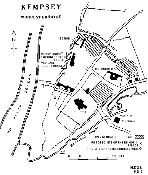
ground, formerly part of the garden of Court House, appeared to be built up into a formidable rampart.

The second trench, Section II, was across the west bank to examine its construction.

The third trench, Section III, was to locate the position of the ditch outside the northern rampart in that part of the area destroyed by the gravel digging of 1836.
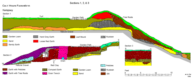

SECTION I. (Fig. 3)
   The trench, running south to north, was 62 feet long, 35 feet of which was on the summit of the gravel terrace and 27 feet down to the base of the bank. Bounding the edge of the terrace is a small retaining bank planted with trees. It is 2 feet 6 inches high and 9 feet wide.

The levels of soil encountered in the trench on the terrace were few, consisting of a deep deposit of garden loam below a shallow turf line. The garden loam lay for 17 feet at its southern end on a disturbed mixture of sandy earth but below this and elsewhere along the trench pinkish sand on undisturbed gravel constituted the natural sub-soil. It was not easy to differentiate between levels in the garden loam as deep cultivation had taken place. Three levels of finds however were noted; in the upmost one, sherds, roof tiles, earthenware with bright brown glaze with white slip pattern and one clay pipe were found. At a depth of 18 inches, late 17th or early 18th century Staffordshire salt glaze ware, black lustre ware, earthenware with bright brown glaze and one sherd of a bell-mouthed jar in a late medieval style (Fig. II, 2) and two clay pipes were found. At a depth of 3 feet 9 inches, concentrated at the south end of the trench and resting on the natural, were many sherds of an earthenware pitcher decorated round the neck with a pattern of thumbmarking, of 17th century A. D. date. (Fig. II, 1.) Mixed with them were five sherds of  c. 13th century A. D. and three others of a light red ware one of which could be of Roman date. In all three levels broken red roof tiles were present but the greatest amount was in the lowest level.

The small retaining bank was constructed with loose reddish earth mixed with some gravel and lay above a level of the garden loam. It had the appearance of very recent construction. A sherd in the red filling was of red earthenware with a bright brown glaze while a sherd in the garden loam below was of a similar earthenware but with a purple glaze. Below these levels was a layer of a compact dry grey soil, the original surface on the natural gravel, but here piled up into a bank on the edge of the gravel pit below. Northward of the retaining bank there was a steep drop (c. 14 feet) to the base of the bluff, exposing the extent of the gravel working. The gravel had been cut away in a straight face to a depth of 3 feet and below that into a slope stretching for 18 feet. Deposits of modern rubbish and cinders were found at the end of the trench at the bottom of the terrace and


Page 42

beyond that the cultivated garden was once more encountered. No finds were made in the trench descending the bank. It was clear that the north-west corner of the earthwork had been completely removed as stated by Jebez Allies. A date for the erection of the retaining bank on the edge of the bluff may be gathered from the following facts and gives a date for the earthenware vessels with bright brown and purple glazes found in the make-up of the bank. The bank is part of a scheme of landscape gardening, as it is accompanied with sloping paths, flights of steps and the revetting of the high bank with staddles and other ornamental stones. This work could not have been carried out before 1835 as the gravel pit was only opened then. The Rev. R. C. Purton, living in the Vicarage (now Court House) from 1895, mentions a square of earthwork near the house, presumably mistaking the retaining bank as part of it. There is also the information that the Parsonage farm-house becomes the vicarage, c. 1875.1 Therefore a late mid-Victorian date for the landscape gardening, when the house and garden became a gentleman's residence, seems justified. A similar date too can be given the earthenware while the trees growing on the bank are considered to be some 80-90 years old.


SECTION II. (Fig. 3)
   The trench, running east to west, was 37 feet long and was dug at right angles to Section I, across the west bank near the north-west angle of the earthwork. Evidence from the trench was disappointing as the bank at this point had been mutilated by the laying of modern drainage and the insertion of a poorly built revetment wall on the brow of the bank. At the east end of the trench on the summit of the gravel terrace and below the loose top soil, the filling was of undisturbed sandy earth resting on a level of loose or as called locally "moving" sand. The deep garden loam of Section I was not present. Further down the slope the filling was of a harder and more compact earth, while a deposit of the compact dry grey soil similar to that found on the natural gravel in Section I was present bordering the "moving" sand on its downward edge. There was more disturbance by deposits of rubbish of modern building material at the west end of the trench. The bank here was thickly planted with a row of fine chestnut trees and as these were scheduled for preservation disturbance of their roots had to be avoided, thus hampering further excavation. An interesting phenomenon was observed in connection with the area dug for the drain; here the rootlets of nearby trees filled the looser earth only, defining clearly the limits of the trench for the drain. The natural gravel terrace was just located towards the west end of the trench. The revetment wall, 1 foot six inches high and 2 feet wide, was built of blocks of new red sandstone. It stood two courses high and was

Notes
1. The atrocious red brick additions to Court House belong to this period.


Page 43

only faced outwards, being roughly backed with rubble and set into the earth bank behind. Amongst the rubble used in the wall were fragments of red roof tiles and bricks. Only one sherd of red earthen ware was recovered from the trench, coming from the disturbed filling of the drain.


SECTION II. (Fig. 3)
   A short trench 8 feet 6 inches long was opened just within the southern hedge of the lane running down to the Severn, to the north of the earthwork. The ground here had been worked for gravel and subsequently leveled for a garden and only faint indications remained suggesting the line of a ditch and base of a rampart. Excavation showed two layers of earth fillings below the top soil. The upper layer was of brown earth mixed with grey pebbles and the lower of a compact sandy earth resting on a deep layer of natural sand. At the north end of the trench a small drainage gully filled with a soft dark silty earth had been cut into the sand and its sides coated with a thin layer of hard brown clayey earth. The form of the gully was clearly cut in a U-shape, 2 feet wide at top to 12 inches at bottom and 9 inches deep. The bottom of the gully lay 4 feet 9 inches from present ground level. Further excavation northwards was not possible owing to the hedge and the lane. It can be assumed that the gully would occupy the centre of the bottom of the original ditch.

It was quite clear that the gully was an original feature as there were no indications of disturbance through the two upper layers above it. Except for a few finds, such as a fragment of a brown earthenware ink jar and some red roof tiles in the surface soil, the only stratified find was one sherd of a hand-made black vessel of Early Iron Age date. It came from a position just over or just in the filling of the gully but was only seen after it had been thrown out from the trench. The small amount of evidence gained from this trench suggests that the original ditch may have been a wide shallow one with layers of silting still remaining. The presence of this type of gully in a ditch, however, is a problem.

Finds:

Pottery 
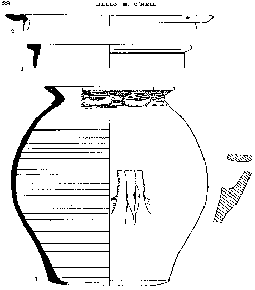
Fig. 2. No. 1 (5/1)1. Pitcher, red earthenware, well made, hard paste. Height 15 inches, rim diameter 7½ inches, base diameter 7 inches. Large thumb marking decoration around neck. Orange glaze on red. The glaze is spread on the top of the rim and within to one inch depth. On the exterior from the neck downwards for c. 8 inches. The interior is only glazed on the bottom and for three inches upwards. Well marked rilling on interior. Lower portion of a handle found but its position on the pitcher missing but the join somewhere below the glazed area. Slightly sagging base. A probable spout. Enough sherds recovered to draw a section from rim to base. From the lowest level of garden loam at the south end of Section 1. 17th century A.D. 1 The figures in brackets refer to the sherd numbers.


Page 44

Fig. 2. No. 2 (5/2). Flanged bowl, red earthenware, hard paste, of medieval type. Rim diameter 9½ inches. c. 13th century A.D. From lowest level of garden loam at south end of Section 1.

From the same level came four other sherds of a similar date representing four different vessels, on sherd of which was a thin black hard ware. Three more sherds of a red ware (5/7 5/8 5/9) Mr. Graham Webster considered as possibly of Roman make but the writer thinks that only (5/7) is. It was noticed that the 17th century Staffordshire salt glaze ware on losing its glaze appeared similar to two of the above sherds.

Fig. 2. No. 3 (2/3). Bell-mouthed jar, buff ware, hard paste. Rim diameter, interior, 10 inches. 17th century A.D. From upper levels of garden loam of Section 1.

From Section III. Not illustrated.
One sherd, from body of hand-made vessel, black, fairly soft paste with small crushed grit and larger particles, some quartz. The paste can be matched from Early Iron Age sherds from Salmonsbury Camp, Bourton-on-the-Water, Glos. It is similar to ware from Bredon and Sutton Wells.1

1 "The excavation of the Iron age Camp on Bredon Hill", Glos. Arch. Journal, XCV. "Excavations at Sutton Wells, Herefordshire", Arch. Journal, CX.

Pre-Roman Roman Dark Ages Domesday Book Medieval Civil War Industrial
Revolution
Victorian Modern Timeline

Home What's New A-Z Index People Index Links Genealogy Church Maps Site Search Sources

Plate 1
The Roman Milestone

Pre-Roman Roman Dark Ages Domesday Book Medieval Civil War Industrial
Revolution
Victorian Modern Timeline

Home What's New A-Z Index People Index Links Genealogy Church Maps Site Search Sources

© 1999 - Andy Morrall

Last updated 15th August 1999.

E-mail: andymorrall@oocities.com


This page hosted by GeoCities Get your own Free Home Page
Click Here!

hits since 9thSeptember 1999.