The Lester Prairie Boulder
South Fork, Crow River, Minnesota
Field Notes: Kevin L. Callahan
Anthropology Department
University of Minnesota
![]()
![]()
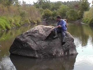
Paul Maravelas examining the Lester Prairie BoulderOn Saturday, September 25, 1999 I went to see a large boulder on private property on the north side of the South Fork of the Crow River in McLeod County near Lester Prairie, Minnesota with Paul Maravelas, Historical Consultant, and former head of the Carver County Historical Society. Paul knows of my interest in the sacred boulders of the Dakota and recalled something he had run across many years ago with reference to a boulder in the vicinity of his house. In the centennial publication for Lester Prairie, researched and written by Barbara and Milan Dammann (R.R.1 Box 147, Lester Prairie, MN 55354), entitled "Lester Prairie Community 1886-1986" on page 127, there is a photograph of two adult women and 4 children sitting on the boulder. The text indicates:
"The large rock is located in Section 9, Bergen Township in the Crow River on the farm now owned by Steve Rosckes. The rock served as a marker for the Indians and a location marker for their camp ground for the summer. The Indians had signs carved into the rock. When they followed the river the rock told them where they were. The Calvary (sic.) also used the rock as a marker for crossing on the river. There is also another rock in the Crow River near the Donald Klaustermeier farm that marked the location of the safest crossing for the white settlers before there was a bridge across the Crow River." [emphasis supplied].
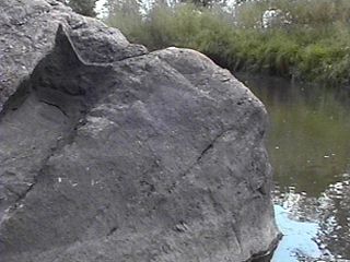
The head of a seated bison?Paul and I met Steve Rosckes at his farm and he showed us where the rock was located on the river. He told us that the rock was attached to the shore when he first lived there. The dirt connecting the boulder to the shore has since eroded away and the boulder is in the river now. Paul and I waded across the shallow river downriver and waded to the boulder. Interestingly, the river has clam shells in it. Clam shells and gorgets made from such shells have religious associations in the ethnographies of Plains Indians. The boulder is pink granite which has some black lichen on it but no white clay residue from weathering suggesting that during floods the boulder is scoured. We looked for rock carvings but found none. From one vantage poiint the boulder looks like a seated buffalo and it is not clear if the "chin" area under the head was formed naturally or was perhaps enhanced. The boulder has a north/south axis orientation for its length in keeping with its probable deposition as a glacial erratic. The boulder is 10 feet 5 inches in length and 7 feet wide. Due to being surrounded by crotch deep water I deferred measuring the circumference of the boulder until perhaps a winter visit when there is ice to stand on. The west side of the boulder has about a 50 degree slope. This boulder is so large that Paul and I both climbed up on it to look for petroglyphs.
A mussel shell in the natural spring's runoff near the boulderPaul indicated that his review of McLeod County's history reveals that a good deal of military activity occurred in this area during the 1862 Dakota Conflict. The conflict began in nearby Acton, Meeker County. Hutchinson was fortified and put under siege. Little Crow was killed north of the town in 1863. He suspects that this may be the reason that there is history regarding the cavalry crossing the river near the boulder.
Near the boulder we found what looked like a field drainage pipe and also a natural spring. The location of the boulder on a river next to a natural spring and composed of pink granite suggests that the account of Native American's carving signs into the rock was likely and erosion or spalling has probably removed the carvings. Additional research to find drawings of the petroglyphs and ethnohistorical references to this important boulder is needed.
This is but one of many sacred boulders of the Dakota in the general Twin Cities area. Others existed at Newport Minnesota, Lake Minnetonka, Eden Prairie, Shakopee, and near Kaposia or South St. Paul. Other sacred boulders existed at Winona, Mille Lacs, Brown's Valley, Lake Traverse, etc. For more information on the rock art, boulders and Dakota religious beliefs associated with this phenomena consult my home page and associated links for other research I have conducted on this topic.

Links to other sites on the Web
This page hosted by Get your own Free Home Page