Baja Verapaz

GUATEMALA


Departament: Baja Verapaz

Name Meaning - "Lower True Peace"

DEPARTMENTAL INFORMATION

Area -
3,124km2/1,940mi2

Population -
228,633

Languages-
Spanish, Pocomchi, Achi

Borders -
Alta Verapaz to the North;
El Progreso to the East;
El Quiche to the West;
Guatemala and Chimaltenango to the South
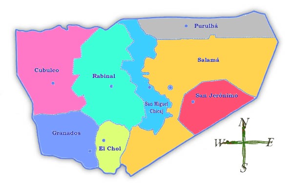
Has 8 districts -
Cubulco
Rabinal
El Chol
Salamá
Granados
San Jerónimo
Purulhá
San Miguel Chicaj

District Map - Mapa Municipal

Coat of Arms - Escudo de Armas

PICTURES-

CHOOSE A DISTRICT OR MUNICIPALITY FROM THE MENU BELOW

.

Free Message Forum from Bravenet Free Message Forums from Bravenet
Free Guestbook from Bravenet Free Guestbook from Bravenet

DEPARTMENTAL FEATURES - *=denotes shared feature with another department.

Volcanoes/Mountains - None

Lakes/Lagoons/Rivers -
*Rio Chixoy
*Rio Polochic
*Rio Salinas
*Rio Grande

RECEPIES AND TRADITIONAL DISHES - 454. Tupes 455. Panza 456. Frijoles Blancos con Espinazo 457. Arroz con Apio 458. Hilachas Salamatecas 459. Lechon al Horno 460. Pescado de Semana Santa (Santa Cruz el Chol) 461. Dulce de Manzanilla 462. Caldo Regional 463. Boshboles

DEPARTMENTAL HOLIDAYS AND CELEBRATIONS-

TOURIST GETAWAYS -

PICTURES-

LINKS/OTHER-

© 1997 - 2004 E-MAIL

Back to Map

This page hosted by GeoCities Get your own Free Home Page