Kanchenjunga Beckons
|
||||||||||||||||||||||||||||||||||||||||||||||||||||||||||||||||||||||||||||||||||||||||||||||||||||||||||||||||||||||||||||||||||||||||||||||||||||||||||||||||||||||||||||||||||||||||||||||||||||||||||||
|
|
||||||||||||||||||||||||||||||||||||||||||||||||||||||||||||||||||||||||||||||||||||||||||||||||||||||||||||||||||||||||||||||||||||||||||||||||||||||||||||||||||||||||||||||||||||||||||||||||||||||||||||
|
|
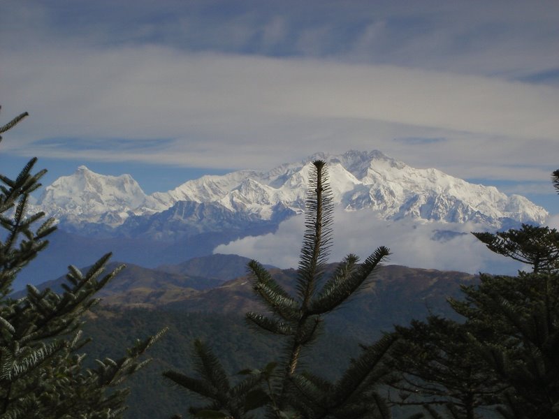
Third Highest Peak in the world One of the difficult peaks to
climb Only eight thousand meters
mountain that offers a view from nearby towns and plains
|
|||||||||||||||||||||||||||||||||||||||||||||||||||||||||||||||||||||||||||||||||||||||||||||||||||||||||||||||||||||||||||||||||||||||||||||||||||||||||||||||||||||||||||||||||||||||||||||||||||||||||||
|
|
||||||||||||||||||||||||||||||||||||||||||||||||||||||||||||||||||||||||||||||||||||||||||||||||||||||||||||||||||||||||||||||||||||||||||||||||||||||||||||||||||||||||||||||||||||||||||||||||||||||||||||
This page is dedicated to the
souls
resting on the lap of Kanchenjunga in their exploration
endeavour
|
||||||||||||||||||||||||||||||||||||||||||||||||||||||||||||||||||||||||||||||||||||||||||||||||||||||||||||||||||||||||||||||||||||||||||||||||||||||||||||||||||||||||||||||||||||||||||||||||||||||||||||
|
|
||||||||||||||||||||||||||||||||||||||||||||||||||||||||||||||||||||||||||||||||||||||||||||||||||||||||||||||||||||||||||||||||||||||||||||||||||||||||||||||||||||||||||||||||||||||||||||||||||||||||||||
|
|
|
|
|
|||||||||||||||||||||||||||||||||||||||||||||||||||||||||||||||||||||||||||||||||||||||||||||||||||||||||||||||||||||||||||||||||||||||||||||||||||||||||||||||||||||||||||||||||||||||||||||||||||||||||
|
|
||||||||||||||||||||||||||||||||||||||||||||||||||||||||||||||||||||||||||||||||||||||||||||||||||||||||||||||||||||||||||||||||||||||||||||||||||||||||||||||||||||||||||||||||||||||||||||||||||||||||||||
|
|
Himalaya
The Great Mountain Range: Himalaya extends from Hidukush in the west to
Brahmaputra in the east. Its length is 1500 miles straight along the air.
Explorer Sidney Burad published a map in 1907. He subdivided the whole range
into 4 regions: 1.
Punjab
Himalaya (Shivalik) 2.
Kumayun
Himalaya 3.
Nepal Himalaya 4. Assam Himalaya Afterwards
a portion of the Nepal Himalaya was renamed as a separate zone as: 5. Sikkim Himalaya Kanchanjunga
is situated in this Sikkim Himalaya. Nepal forms its West boundary and Sikkim is at the
west. Kanchenjunga is situated at the confluence of four ridges. Starting from the top, the East Ridge drops into the Jemu gap. More easts are Simvo massive and Siniolchu. The peaks on the West ridge are Janu and kang –Ba -Chen etc. the North ridge is having many peaks like Twin peak, Nepal Peak, Tent peak etc. The South ridge extends 60 Kilometers southwards as Singalila Ridge upto Manebhanjan and Dhotrey. Talung (23,082 ft.), Kabru (24,002 ft.) etc. are the peaks on this ridge. |
|||||||||||||||||||||||||||||||||||||||||||||||||||||||||||||||||||||||||||||||||||||||||||||||||||||||||||||||||||||||||||||||||||||||||||||||||||||||||||||||||||||||||||||||||||||||||||||||||||||||||||
|
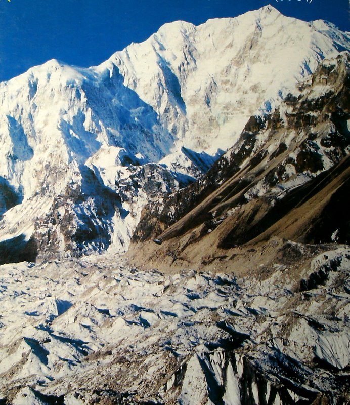
Kanchenjunga South-West face |
||||||||||||||||||||||||||||||||||||||||||||||||||||||||||||||||||||||||||||||||||||||||||||||||||||||||||||||||||||||||||||||||||||||||||||||||||||||||||||||||||||||||||||||||||||||||||||||||||||||||||||
|
|
||||||||||||||||||||||||||||||||||||||||||||||||||||||||||||||||||||||||||||||||||||||||||||||||||||||||||||||||||||||||||||||||||||||||||||||||||||||||||||||||||||||||||||||||||||||||||||||||||||||||||||
|
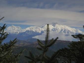
Kanchenjunga from Chitrey |
||||||||||||||||||||||||||||||||||||||||||||||||||||||||||||||||||||||||||||||||||||||||||||||||||||||||||||||||||||||||||||||||||||||||||||||||||||||||||||||||||||||||||||||||||||||||||||||||||||||||||||
|
|
||||||||||||||||||||||||||||||||||||||||||||||||||||||||||||||||||||||||||||||||||||||||||||||||||||||||||||||||||||||||||||||||||||||||||||||||||||||||||||||||||||||||||||||||||||||||||||||||||||||||||||
|
Kanchenjunga
Nomenclature: The mountain is situated
in Sikkim. The Lepcha community of Sikkim named it as Kong –Lo – Chu. Some-where it is named
as King –Chung –Jung –Bu. Lepcha community of Sikkim worships the peak as their God. Every year in the third moon month they celebrate the festival of adoration. In front of their houses they make a replica of the mountain by using nine stone pieces and idolise it. Mask dance is a ritual in this festival. They believe that the blessings of the Himalaya that is the mountain Kong –Lo –Chu can only keep them healthy and wealthy. The Sikkimese people have maintained the sanctity of their belief all through out the passage of time. The king of Sikkim while permitting any expedition in the past has always imposed a condition that the summiteers must not step the top. The days of the Kings are no more. Being a part of democratic India, there is Sikkim government now a day. However the expeditionary with a holy spirit in their mind have always religiously respected the ‘verdict of the king’. Till date a total of195 summiteers have resorted down leaving 6 feet of height to the top that is about 20 feet in length as a gratitude to the belief of the surrounding community whose permission and whole-hearted support can only run an expedition in line. Tibet does
not form any boundary of Kanchenjunga but it is only 15 Kilometers apart. In
Tibetan language the peak is named as “Kang – Chen – Dzo
-Nga”. It means “Five
treasuries of the great snow”. The most popular and the
modern name “Kanchenjunga” has been derived from this Tibetan pronunciation. The five peaks those act as the treasurers of the
great snow are:
In 1845 Michael Hennessy of Survey of India first started identifying the Himalayan peaks by Roman number. The numbering started from the east end of the Himalayan range. Unknown Kanchenjunga was numbered as Peak XIII and Everest as Peak XV. Afterwards Surveyor General Montgomery sent Pundit explorer Hariram to find out and recommend any local name for this peak. Accordingly “Kanchenjunga” immersed out as the final choice. |
|
|||||||||||||||||||||||||||||||||||||||||||||||||||||||||||||||||||||||||||||||||||||||||||||||||||||||||||||||||||||||||||||||||||||||||||||||||||||||||||||||||||||||||||||||||||||||||||||||||||||||||||
|
Deity of Kanchenjunga as per Lepcha mythology |
||||||||||||||||||||||||||||||||||||||||||||||||||||||||||||||||||||||||||||||||||||||||||||||||||||||||||||||||||||||||||||||||||||||||||||||||||||||||||||||||||||||||||||||||||||||||||||||||||||||||||||
|
|
||||||||||||||||||||||||||||||||||||||||||||||||||||||||||||||||||||||||||||||||||||||||||||||||||||||||||||||||||||||||||||||||||||||||||||||||||||||||||||||||||||||||||||||||||||||||||||||||||||||||||||
|
Kanchenjunga from Green lake |
||||||||||||||||||||||||||||||||||||||||||||||||||||||||||||||||||||||||||||||||||||||||||||||||||||||||||||||||||||||||||||||||||||||||||||||||||||||||||||||||||||||||||||||||||||||||||||||||||||||||||||
|
|
||||||||||||||||||||||||||||||||||||||||||||||||||||||||||||||||||||||||||||||||||||||||||||||||||||||||||||||||||||||||||||||||||||||||||||||||||||||||||||||||||||||||||||||||||||||||||||||||||||||||||||
|
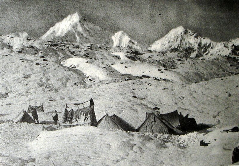
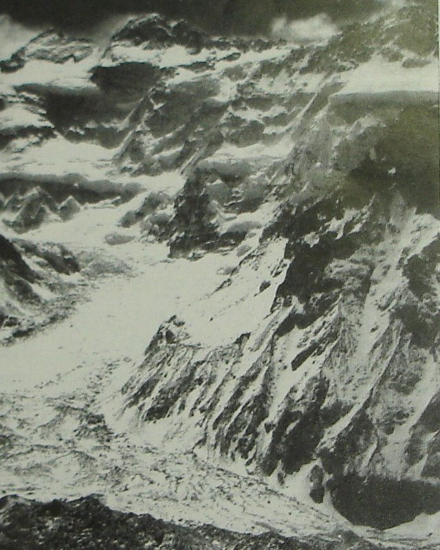
Base Camp on Jemu glacier |
||||||||||||||||||||||||||||||||||||||||||||||||||||||||||||||||||||||||||||||||||||||||||||||||||||||||||||||||||||||||||||||||||||||||||||||||||||||||||||||||||||||||||||||||||||||||||||||||||||||||||||
|
|
||||||||||||||||||||||||||||||||||||||||||||||||||||||||||||||||||||||||||||||||||||||||||||||||||||||||||||||||||||||||||||||||||||||||||||||||||||||||||||||||||||||||||||||||||||||||||||||||||||||||||||
|
|
||||||||||||||||||||||||||||||||||||||||||||||||||||||||||||||||||||||||||||||||||||||||||||||||||||||||||||||||||||||||||||||||||||||||||||||||||||||||||||||||||||||||||||||||||||||||||||||||||||||||||||
|
|
Speciality
of Kanchenjunga: Kanchenjunga is outside
the main Himalayan ridge. It is not a high point on a continuous mountain
ridge. Instead it is the top crown in the middle of five peaks.
‘Kanchenjunga-main’ is one in those five. Vital Statistics:
Difficult
Peak: Kanchenjunga is a very
difficult peak to climb. In the group of more than 8000 meters high peaks,
Nanga-parbat is regarded as the most difficult due to its character of sudden
worsening of the weather condition. Kanchenjunga is respected to be very
difficult due to the hard winds on its heights. The contour of the faces is
also unfriendly to climb. Douglas Freshfield made a circular tour
around Kanchenjunga in 1899 at his 54 years of age and wrote a book “Round Kanchenjunga”, Excerpt from the book
says “The
whole face of the mountain, might be imagined to have been constructed by the
Demon of Kanchenjunga for the express purpose of defense against human
assault, so skillfully is each comparatively weak spot raked by the ice and
snow batteries.” Sir John Hunt was the leader of the
first successful expedition to Everest in 1953. He was asked after his
success: What next? “Kanchenjunga” was the
answer. His feelings about the
mountain was “There is no
doubt that those who first climb Kanchenjunga will achieve the greatest feat in
mountaineering, for it is a mountain which combines in its defense not only
the severe handicaps of wind, weather and very high altitude, but technical
climbing problems and objective dangers of an order ever higher than those we
encountered on Everest.” Dr. Charles Evans was the leader of the first successful expedition to Kanchenjunga in 1955. He published his book “Kanchenjunga – the un-trodden peak” on this expedition in 1956. Mr. Cooke reviewed the book as follows, “This book is the official account of one of the greatest mountaineering achievements in the history of climbing…..the summit was almost regarded as impregnable, but Evans and his colleagues have dispelled that idea at one master stroke; they surmounted all the difficulties and left only the final white cone of snow un-trodden.” |
|||||||||||||||||||||||||||||||||||||||||||||||||||||||||||||||||||||||||||||||||||||||||||||||||||||||||||||||||||||||||||||||||||||||||||||||||||||||||||||||||||||||||||||||||||||||||||||||||||||||||||
|
Kanchenjunga from Tumbling |
||||||||||||||||||||||||||||||||||||||||||||||||||||||||||||||||||||||||||||||||||||||||||||||||||||||||||||||||||||||||||||||||||||||||||||||||||||||||||||||||||||||||||||||||||||||||||||||||||||||||||||
|
|
||||||||||||||||||||||||||||||||||||||||||||||||||||||||||||||||||||||||||||||||||||||||||||||||||||||||||||||||||||||||||||||||||||||||||||||||||||||||||||||||||||||||||||||||||||||||||||||||||||||||||||
|
Kanchenjunga Glacier |
||||||||||||||||||||||||||||||||||||||||||||||||||||||||||||||||||||||||||||||||||||||||||||||||||||||||||||||||||||||||||||||||||||||||||||||||||||||||||||||||||||||||||||||||||||||||||||||||||||||||||||
|
|
||||||||||||||||||||||||||||||||||||||||||||||||||||||||||||||||||||||||||||||||||||||||||||||||||||||||||||||||||||||||||||||||||||||||||||||||||||||||||||||||||||||||||||||||||||||||||||||||||||||||||||
|
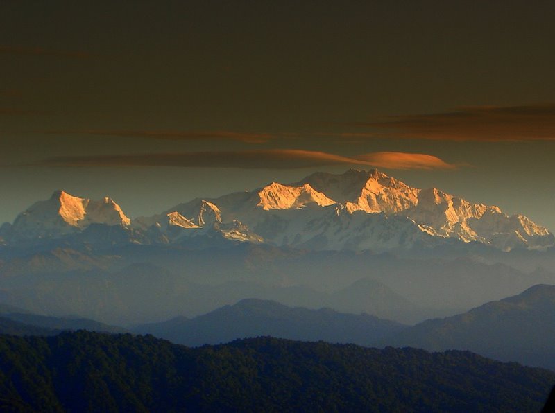
Kanchenjunga from Sandakphu |
||||||||||||||||||||||||||||||||||||||||||||||||||||||||||||||||||||||||||||||||||||||||||||||||||||||||||||||||||||||||||||||||||||||||||||||||||||||||||||||||||||||||||||||||||||||||||||||||||||||||||||
|
|
||||||||||||||||||||||||||||||||||||||||||||||||||||||||||||||||||||||||||||||||||||||||||||||||||||||||||||||||||||||||||||||||||||||||||||||||||||||||||||||||||||||||||||||||||||||||||||||||||||||||||||
|
Kanchenjunga North-West face |
||||||||||||||||||||||||||||||||||||||||||||||||||||||||||||||||||||||||||||||||||||||||||||||||||||||||||||||||||||||||||||||||||||||||||||||||||||||||||||||||||||||||||||||||||||||||||||||||||||||||||||
|
|
||||||||||||||||||||||||||||||||||||||||||||||||||||||||||||||||||||||||||||||||||||||||||||||||||||||||||||||||||||||||||||||||||||||||||||||||||||||||||||||||||||||||||||||||||||||||||||||||||||||||||||
|
|
||||||||||||||||||||||||||||||||||||||||||||||||||||||||||||||||||||||||||||||||||||||||||||||||||||||||||||||||||||||||||||||||||||||||||||||||||||||||||||||||||||||||||||||||||||||||||||||||||||||||||||
|
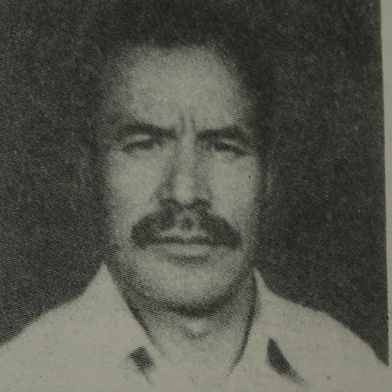
First Successful Expedition:
The Leader: Dr. Charles Evans (36
Years). He was a surgeon at Liverpool. He was the Dy. Leader of the 1st
successful expedition to Everest in 1953. He was in the 1st
assault team of the 1953 Everest expedition. In 26th May 1953 the
1st assault team Charles Evans and Tom Bordilon climbed up to
28,742 feet of the south summit of Everest. The oxygen cylinder did not
function properly and so they had to retread leaving behind 293 feet height
to reach the top of the world. Sir Edmund Hillary and Tenzing Norgey succeeded
on 29th May in the same expedition. Some interesting events of
the first successful expedition: 3rd camp was
not a tent. It was prepared by cutting a cave on the ice. That was to avoid
the hard wind on the Kanchenjunga surface. 20 open circuit and 2
closed circuit oxygen cylinders were used. 5th camp was
established at a height of 25,000 feet. The final assault camp was 6th
camp at a height of 27,000 feet. It regularly took two
hours time to prepare water by boiling ice. George Band once removed
his outer gloves and took 15 seconds to set the oxygen valve. His inner
silken gloves were on. But the 15 seconds exposure was enough for the biting
cold to develop blisters on his hand. Members of the expedition
team: 1.
Dr. Charles Evans (36 Years) Leader 2.
Norman Hardi (30 Years) Dy. Leader. He was from New Zeeland 3.
George Band (26 Years) 4.
Neil Mather (26 Years) 5.
Joe Brown (24 Years) 6.
Dr. John Cleg (29 Years) Medical Officer 7.
Tony Streather (29 Years) 8.
John Jackson (34 Years) 9.
Tom Makinon (42 Years) Sponsor of the expedition: 1.
Alpine Club 2.
Royal Geographical Society 3.
Duke of Edinburgh Description of the 1st
successful expedition: The March started on 14th
march 1955 from Rangeet Tea Estate at Darjeeling. There were 319 porters and
36 High Altitude Porters (HAP who will act as porter above the base camp).
Baggage weight was 6 Tons. The team progressed along
the route as follows: Manebhanjan - Tonglu -
Sandakphu - Falut - Mehley - Khewang
- Yamfodin - Tserum - Ramtsere. They climbed along the
South West face. Sherpa Pemi Dorji died in cerebral thrombosis in this expedition. No accidental death happened in this expedition. |
|
|||||||||||||||||||||||||||||||||||||||||||||||||||||||||||||||||||||||||||||||||||||||||||||||||||||||||||||||||||||||||||||||||||||||||||||||||||||||||||||||||||||||||||||||||||||||||||||||||||||||||||
|
Dr. Charles Evans. The leader of the first successful expedition to Kanchenjunga in 1955 |
||||||||||||||||||||||||||||||||||||||||||||||||||||||||||||||||||||||||||||||||||||||||||||||||||||||||||||||||||||||||||||||||||||||||||||||||||||||||||||||||||||||||||||||||||||||||||||||||||||||||||||
|
|
||||||||||||||||||||||||||||||||||||||||||||||||||||||||||||||||||||||||||||||||||||||||||||||||||||||||||||||||||||||||||||||||||||||||||||||||||||||||||||||||||||||||||||||||||||||||||||||||||||||||||||
|
George Band. First summiteers to Kanchenjunga in 1955 |
||||||||||||||||||||||||||||||||||||||||||||||||||||||||||||||||||||||||||||||||||||||||||||||||||||||||||||||||||||||||||||||||||||||||||||||||||||||||||||||||||||||||||||||||||||||||||||||||||||||||||||
|
|
||||||||||||||||||||||||||||||||||||||||||||||||||||||||||||||||||||||||||||||||||||||||||||||||||||||||||||||||||||||||||||||||||||||||||||||||||||||||||||||||||||||||||||||||||||||||||||||||||||||||||||
|
Major Premchand. First Indian summiteers in 1977 |
||||||||||||||||||||||||||||||||||||||||||||||||||||||||||||||||||||||||||||||||||||||||||||||||||||||||||||||||||||||||||||||||||||||||||||||||||||||||||||||||||||||||||||||||||||||||||||||||||||||||||||
|
|
||||||||||||||||||||||||||||||||||||||||||||||||||||||||||||||||||||||||||||||||||||||||||||||||||||||||||||||||||||||||||||||||||||||||||||||||||||||||||||||||||||||||||||||||||||||||||||||||||||||||||||
|
George Band and Col. Narindar Kumar. Col. Kumar was the leader of the first successful Indian expedition to Kanchenjunga in 1977 |
||||||||||||||||||||||||||||||||||||||||||||||||||||||||||||||||||||||||||||||||||||||||||||||||||||||||||||||||||||||||||||||||||||||||||||||||||||||||||||||||||||||||||||||||||||||||||||||||||||||||||||
|
|
||||||||||||||||||||||||||||||||||||||||||||||||||||||||||||||||||||||||||||||||||||||||||||||||||||||||||||||||||||||||||||||||||||||||||||||||||||||||||||||||||||||||||||||||||||||||||||||||||||||||||||
|
|
||||||||||||||||||||||||||||||||||||||||||||||||||||||||||||||||||||||||||||||||||||||||||||||||||||||||||||||||||||||||||||||||||||||||||||||||||||||||||||||||||||||||||||||||||||||||||||||||||||||||||||
|
Indian
Expeditions to Kanchenjunga:
|
||||||||||||||||||||||||||||||||||||||||||||||||||||||||||||||||||||||||||||||||||||||||||||||||||||||||||||||||||||||||||||||||||||||||||||||||||||||||||||||||||||||||||||||||||||||||||||||||||||||||||||
|
|
||||||||||||||||||||||||||||||||||||||||||||||||||||||||||||||||||||||||||||||||||||||||||||||||||||||||||||||||||||||||||||||||||||||||||||||||||||||||||||||||||||||||||||||||||||||||||||||||||||||||||||
|
|
||||||||||||||||||||||||||||||||||||||||||||||||||||||||||||||||||||||||||||||||||||||||||||||||||||||||||||||||||||||||||||||||||||||||||||||||||||||||||||||||||||||||||||||||||||||||||||||||||||||||||||
|
Foreign
Expeditions to Kanchenjunga:
|
||||||||||||||||||||||||||||||||||||||||||||||||||||||||||||||||||||||||||||||||||||||||||||||||||||||||||||||||||||||||||||||||||||||||||||||||||||||||||||||||||||||||||||||||||||||||||||||||||||||||||||
|
|
||||||||||||||||||||||||||||||||||||||||||||||||||||||||||||||||||||||||||||||||||||||||||||||||||||||||||||||||||||||||||||||||||||||||||||||||||||||||||||||||||||||||||||||||||||||||||||||||||||||||||||
|
|
|
This is a bhuniazone page
|
Queries and feedbacks
|
|||||||||||||||||||||||||||||||||||||||||||||||||||||||||||||||||||||||||||||||||||||||||||||||||||||||||||||||||||||||||||||||||||||||||||||||||||||||||||||||||||||||||||||||||||||||||||||||||||||||||
|
|
||||||||||||||||||||||||||||||||||||||||||||||||||||||||||||||||||||||||||||||||||||||||||||||||||||||||||||||||||||||||||||||||||||||||||||||||||||||||||||||||||||||||||||||||||||||||||||||||||||||||||||
|
The Team bhuniazone |
|
|||||||||||||||||||||||||||||||||||||||||||||||||||||||||||||||||||||||||||||||||||||||||||||||||||||||||||||||||||||||||||||||||||||||||||||||||||||||||||||||||||||||||||||||||||||||||||||||||||||||||||
|
The raw
materials and the historical pictures: Courtesy ‘Jara Jajabar’ Bengali
magazine Write up and Photographs by Dr. J. Bhunia |
||||||||||||||||||||||||||||||||||||||||||||||||||||||||||||||||||||||||||||||||||||||||||||||||||||||||||||||||||||||||||||||||||||||||||||||||||||||||||||||||||||||||||||||||||||||||||||||||||||||||||||