|
[ UrbanRail.Net ] [ Europe ] [ America ] [ Asia ] [ Africa ] [ News ] [ Books ] [ Links ] |
| England . UK |
Click here to expand map to full size
|
System
and History
|
||||||||||||||||||||||||||||||||||||||||||||||
|
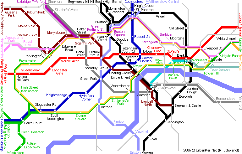
* Shoreditch station on the East London Line closed permanently on 9 June 2006 19th CENTURY - THE BEGINNINGSLondon is the mother of all the world's metro systems. Already in 1863 the first tunnel was opened in the city centre for a rail line between Paddington (originally called Bishops Rd) and Farringdon although trains of the Metropolitan Railway were operated initially by steam engines. In the following decades the line was extended east and west, and reached Hammersmith in 1864, South Kensington in 1868, Aldgate in 1876, and Tower of London in 1882. A northwestern branch was opened from Baker Street to Swiss Cottage in 1868 which was later extended in stages as far as Chesham by 1889.
In the meantime, between 1868 and 1871, the Metropolitan District Railway built a line between South Kensington and Mansion House. The entire circle was finished in 1884 with the Mansion House - Tower section. The District was also extended at both ends during the following decades and served Hammersmith in 1874, Richmond in 1877, Ealing Broadway in 1879 and Wimbledon in 1889. The Metropolitan Line persists on the London Underground map (although part of the original line now is the Hammersmith & City Line) and has become a synonym all over the world for many different kinds of urban rail transport systems. This first line was so successful that very quickly a large network of underground and surface lines was built. In 1900, when Paris opened its first line, London already was proud of a very extensive metro system.
The first "real" metro line, however, was the City & South London Railway, between Stockwell and King William Street (later replaced by Bank) in the City of London, which opened 4 Nov 1890 and which is part of today's Northern Line. This was the first underground line using electric traction in the world. In 1898, 2 years after Glasgow's cable drawn subway and Budapest's first electric underground line had opened, another short electric tube line started operating in London, this is today's Waterloo & City Line. From 1900 onwards, the Metropolitan and the District Railways began electrifying all their lines.
<<< Top of Page | Fares | 19th Century | 20th Century | Future | Books & Videos | Links 20th CENTURYGreater London is home to some 8 million people and apart from the London Underground, a dense network of commuter railways (former Network SouthEast) is operated by several private companies like Connex, Thameslink or First, especially in the south of the city. Most of today's underground lines were built in the first half of the 20th century in deep level tube tunnels within the central area of London and extended above ground through the suburbs. Apart from the Jubilee Line extension described below, the Victoria Line was the last important addition to the network (opened 1968-71).
In South London, around Croydon, a modern tram network was built which runs on street level in downtown Croydon and on old BR rail alignments on outer routes. The system opened for traffic in summer 2000. In 1993 construction work for the south-east extension of the Jubilee Line began. The above ground section between Stratford and North Greenwich opened May 14, 1999 with a limited service Monday - Friday. The second section from North Greenwich to Bermondsey has been operating since Sept. 17, 1999. On 24 Sept. 1999 trains ran to Waterloo for the first time without stopping at the intermediate stations. On 7 Oct. 1999 also London Bridge station was put into service. The missing section between Waterloo and Green Park was put into service without celebrations on 20 November 1999 (plus Southwark station) although Westminster Station opened later, on 22 Dec. 1999. Former Jubilee Line terminus at Charing Cross was closed on 20 Nov. 1999. <<< Top of Page | Fares | 19th Century | 20th Century | Future | Books & Videos | Links |
||||||||||||||||||||||||||||||||||||||||||||||
|
Jubilee Line Extension |
||||||||||||||||||||||||||||||||||||||||||||||
|
The Piccadilly Line is being extended to serve the new Terminal 5 at Heathrow Airport (3.4km). Until late 2006, the current Terminal 4 station will be closed to allow the construction of this extension. For suburban rail services a new tunnel (Crossrail line 1) is planned between Liverpool Street and Paddington via Holborn and Bond St. Preliminary works on this RER type system began in 2002, completion is scheduled for 2012. To relieve congestion along the Victoria Line, a new diagonal underground route was planned (referred to as the Chelsea-Hackney Line). This line would have included the Wimbledon branch of the District Line as far as Parsons Green, then run diagonally through Central London via Sloane Sq, Victoria, Piccadilly Circus, Tottenham Court Rd and King's Cross/St.Pancras, then west to Leytonstone on the Central Line from where it would take over one branch of that line. Instead, the latest plans released in 2002 study the construction of a diagonal Crossrail line 2. For the Docklands Light Railway construction of a further extension under the River Thames from King George V to Woolwich Arsenal began in 2005 for completion in time for the 2012 Olympics. Another extension of the Docklands Light Railway from Canning Town to the future Stratford International station is in preparation. The proposed 5 km route would take over the present North London Line route and have four additional stations - at Star Lane, Abbey Road, Stratford High Street and Stratford International. The existing stations at Canning Town, West Ham and Stratford would also be upgraded. It is planned to open in early 2010, 2 years ahead of the Olympic Games. <<< Top of Page | Fares | 19th Century | 20th Century | Future | Books & Videos | Links |
||||||||||||||||||||||||||||||||||||||||||||||
|
For an updated book list on the London Underground click here
|
||||||||||||||||||||||||||||||||||||||||||||||
|
The capital of the United Kingdom of Great Britain and Northern Ireland lies in the south of England by the river Thames and has about 8 million inhabitants. - OPERATION Underground trains start running from between 5:00 and 5:30 and finish at around midnight. - FARES (for current fares visit TfL) The Greater London area is divided into 6 fare zones, zone 1 is approximately the area covered by the Circle Line, the other five zones are rings around this central zone. Fares are cheaper if the central zone 1 is not included in the trip. Single fare - depending on the number of zones travelled through 1-Day or 3-Day Travelcards offer unlimited travel after 9:30 (off-peak) or all day (peak) on the underground, DLR, buses, tram, and suburban trains Season Tickets offer unlimited travel without time restrictions and are available for 7 days, 1 month or 1 year, but needs a photo ID card. Since July 2003, a smartcard, called Oyster Card, has been in use. <<< Top of Page | Fares | 19th Century | 20th Century | Future | Books & Videos | Links |
||||||||||||||||||||||||||||||||||||||||||||||
|
Transport for London Official Site Docklands Light Rail Official Site Tube Lines (operator of the Jubilee, Northern and Piccadilly lines) Metronet (operator of the Bakerloo, Central, Victoria, Metropolitan, District, Circle, Hammersmith & City and East London lines) History of the London Underground by Lennart Thelander John Rowland's Page (incl. 3D station maps, train frequency tables and other interesting stuff) Always touch out - Public Transport Projects in London Peter Kenny's Going Underground (Curious items around the tube) Great private page on Dockland LR London Tube Maps from 1889 until today Squarewheels - Richard Griffin's Railway Page The Inner Circle by Jacek Wesolowski Ian Peacock's London Railways.Net Raggajohn's London Underground Technical Hywel's Underground History and Disused Stations Carter's Unofficial Guide to the London Underground Tramlink by Stephen J. Parascandolo Plans for the future London rail networks (by John Rowland) Lots of London underground photographs TrainSimCentral - simulator incl. several LU lines by Keith Hazelton and Steve Green TVA Network - London Subway (Description of the early underground construction) East London Line Extension Project (Official Site) Beary's London Underground - deutschsprachige Site über die Londoner U-Bahn UrbanRail.Net > London Underground Gallery Geographically correct map from JohoMaps |
||||||||||||||||||||||||||||||||||||||||||||||
|
|
||||||||||||||||||||||||||||||||||||||||||||||
<<< Top of Page | Fares | 19th Century | 20th Century | Future | Books & Videos | Links
Thanks to Panayiotis Constantinides!
2004 © UrbanRail.Net by Robert Schwandl.


 By
2010, the East London Line will
be extended both towards the south and the north. Phase 1 will extend
the line north to Dalston Junction and south to Crystal Palace
and West Croydon. Along the northern stretch, the stations will
be Shoreditch High Street (to replace the original Shoreditch
station, which closed permanently on 9 June 2006),
Hoxton, Haggerston, Dalston Junction (adjacent
to Silverlink's Dalston Kingsland). Later it will continue to
Canonbury and Highbury & Islington. The southern extension
will have two branches using mainly existing railway corridors, one
towards Clapham Junction and one to West Croydon.
By
2010, the East London Line will
be extended both towards the south and the north. Phase 1 will extend
the line north to Dalston Junction and south to Crystal Palace
and West Croydon. Along the northern stretch, the stations will
be Shoreditch High Street (to replace the original Shoreditch
station, which closed permanently on 9 June 2006),
Hoxton, Haggerston, Dalston Junction (adjacent
to Silverlink's Dalston Kingsland). Later it will continue to
Canonbury and Highbury & Islington. The southern extension
will have two branches using mainly existing railway corridors, one
towards Clapham Junction and one to West Croydon. 