|
Rates of Plate Movement During the Phanerozoic
"I
have no doubt that in the not too distant future we will be
successful in making a precise measurement of the drift of North
America relative to Europe."
Alfred Wegener, 1929
According to various forms of the Noah's Flood model, rates of plate motion during the "Phanerozoic" were on the order of several thousand meters per day, and all or most Phanerozoic crustal displacement is considered to have occured during a brief catastrophe occuring about 2500BCE and lasting only "weeks or months." However, several lines of evidence indicate that plate motion rates obtaining during the Phanerozoic were roughly equivalent to those being measured today, about 15cm or less per year relative to other plates or to assumed fixed hotspots.
There are a variety of methods which can be used to estimate rates of plate movement for given times in the past. For instance, Vine and Matthews' correlation of oceanic magnetic anamolies with the geomagnetic timescale automatically predicted average rates of plate movement over time. For instance, if a given magnetic anamoly is identified with a 10mya reversal event, and is presently 500km from a spreading ridge, then spreading at that ridge must have averaged about 5cm per year over the past 10my. The rates of plate motion suggested by Vine and Matthews' correlation of oceanic magnetic anamolies with the terrestrial polarity reversal timescale ranged from about 2cm per year for the North Atlantic to about 15cm per year for the central South Pacific (Van Andel, p. 118).
Today, the movement of tectonic plates can be directly measured by a variety of geodetic technologies, including satellite laser ranging (SLR), Very Long Baseline Interferometry (VLBI), and Global Positioning Systems (GPS). The rates of plate motion directly measured by these methods, on the order of 15cm or less per year, are in good agreement with rates of plate motion predicted by radiometric dates, by correlation with the geomagnetic timescale, and pelagic sediment biostratigraphy. Such an agreement between prediction and observation is in itself strong evidence that plate motions have not changed radically over time. It is certainly not to be expected on catastrophist models in which modern tectonic processes, if they are not denied altogether, are necessarily viewed as much reduced afteraffects of the flood catastrophe, for in that case we should expect profound disagreement between direct measurements of current plate motions and estimates of past plate motions based on radiometric/biostratigraphic data. Wise (1998) notes:
"Detailed plate motion directions and velocities with their passenger continents (DeMets et al., 1990) have been derived from combinations of geophysics, deep sea drilling, seafloor magnetic anomalies, and land based structural, geophysical, and sedimentological studies, the whole cemented by a time framework based on stratigraphic, paleontologic, and radiometric time scales. Recent satellite-based global positioning system measurements for 38 sites on the different plates show a 95% correlation with the plate tectonic model predictions (Larson et al., 1997). Only the Pacific and Nazca plates needed some readjustment to fit the model. Similar conclusions, using slightly different very long baseline precision measurements from satellite and space geodesy, were reached by Robaudo et al. (1993) . . . To argue that the early runaway subduction processes (Baumgardner, 1994; Austin et al., 1994) have ceased and that measured present day plate motions represent relaxation phenomena which just happen by chance to be a near perfect match with the rates derived from the supposedly invalid and rejected traditional geologic time scale requires complete abandonment of Occam's razor."
The Hawaiian Islands/Emperor Seamounts: A Case Study in Past Plate Motion
For instance, the central Pacific plate is currently moving northwest at about 9cm per year relative to North America. The rate at which the Pacific plate moved in the past can be inferred not only from magnetic lineation within the oceanic crust itself, but also from radiometric dating of volcanic "hotspot traces" which form on top of the Pacific plate as it moves over mantle plumes. Examples of such hotspot traces would include the Marguesas, Society, and Austral islands, all of which trend northwest, perpendicular to the axis of plate spreading.
Assuming that hotspots themselves have moved little over time, and that these linear volcanic features were formed as overriding plate passed over them, the age-trends of the hotspot traces themselves can be used to estimate the rate of motion of the overriding plate. Duff notes that "[m]ore than 30 linear island chains have been identified that show evidence of age progression. Some of these include the Galapagos Seamounts (Sinton et al., 1996), Bahia Seamounts (Bryan and Cherkis, 1995), Cameroon line (Lee et al., 1994), Foundation Seamounts (Mammerickx, 1992), Samoan volcanic chain (Natland, 1980), and numerous ones in the South Atlantic (O'Conner and le Roex, 1992)."
The most famous example of a putative hotspot trace is the Hawaiian Archipeligo, which consists of more than fifty volcanic mountains, most of which are submerged, and spans 6,000 km from the island of Hawaii to the Aleutian Trench. Paleomagnetic evidence shows that all of the Hawaiian islands formed at about the same latitude as Hawaii (Clague and Dalrymple, 1987). Because of progressive subsidence of these volcanic mountains as they move away from the Hawaiian hotspot, only the youngest mountains are still above sea level. All of the Emporer Seamounts are now submerged, some to depths over 2km. The Meiji Seamount in the north Emperor chain, for instance, was once a volcanic island like Hawaii but is now deeply submerged with a sediment cover of over 1km composed of ooze, chalk and clays resting above subaerial basalt.
|
What do the Hawaiian Islands/Emporer Seamounts tell us about the motion of the Pacific plate during the time in which they formed? In the graph below (from Clague and Dalrymple, 1987), radiometric ages of the Hawaii islands/Emporer Seamounts are plotted against distance from the Hawaiian hotspot. There is a very clear correlation between these two variables. In this case, the relationship between age and distance indicates an average rate of about 8.0 cm/yr northwest displacement of the Pacific plate. When the data are examined more closely, it is seen that the rates suggested for the Emperor Seamounts, northwest of the 43my bend, are actually a bit slower (~6.0 cm/yr) than those for the Hawaiian chain itself. This may be a result of slower plate movement, hotspot movement, true polar wonder, or a combination of these factors.
http://www.soest.hawaii.edu/GG/HCV/volc_age.gif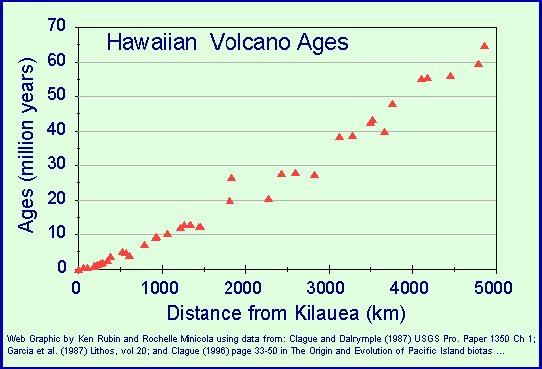
Ages of Hawaiian Islands/Emperor Seamounts as a function of distance from the Hawaiian hotspot. From the Hawaii Center for Volcanology Website.
Rates of Plate Movement Inferred from APW Paths

Paleomagnetic evidence can be used to estimate rates of plate motion throughout the Phanerozoic, provided we accept radiometric dating and the assumption that the earth during the Phanerozoic possessed an axial dipole magnetic field more or less coinciding with the rotational poles as it does today. Actually, this assumption seems quite well founded, since Phanerozoic APW paths seem to agree with the same sequence of rifting/drifting events inferred on other geological evidence.
Rates of oceanic plate movement over time, as we saw, can be estimated from radiometric ages, correlation of magnetic anomolies with geomagnetic timescale, and biostratigraphy of oceanic sediments. These methods only applies to the range of time corresponding to the age range of extant oceanic crust, ~130-0mya. Plate velocities for earlier times rely on continental paleomagnetic data alone. Velocities deduced from APW paths for the past 300my listed by Piper (1987) are equal to 10cm or less anually. Condie notes that "maxima in continental plate velocities often occur just after fragmentation from a supercontinent. For instance, the velocity maxima in the early Mesozoic follow beginning of the breakup of Pangaea, and the peak velocities for Australia and India following rifting of these continents from Gondwana" (1989, p. 154).
Ocean Floor Stratigraphy

Locations of
divergent plate boundaries and sense of plate motion indicated by
arrows.
Map courtesy of NOAA National Geophysical Data Center.
One prediction of catastrophicNoah's Flood tectonic theories such as Runaway Subduction is that virtually all of the currently existing oceanic crust was created during one brief event, lasting perhaps only wekks or months. As shown above, these theories are in serious conflict with paleomagnetic data. Another way to test the Noah's Flood model is provided by the distribution of deep-sea sediments.
Oceanic sedimentation is controlled by several factors, including depth, proximity to detrital sources, and surface water productivity. Consider again the Pacific plate, and the sediments which are accumulating on its surface. At the East Pacific spreading ridge, where the oceanic crust is youngest, there is very little accumulated sediment. Moving northwest off of the rise and into deeper waters, carbonate and smaller amounts of siliceous sediments are found overlying oceanic crust. These become progressively thicker as one moves northwest. These sediments are accumulating at a rate of approximately 20-60mm/1000yr (Berger, 1974).
At a depth of about 4500m, which would be passed several hundred miles from the ridge, we reach the Carbonate Compensation Depth or CCD. The CCD represents the depth at which the rate of carbonate accumulation equals the rate of carbonate dissolution. As we continue our journey northwest, across a portion of the ocean floor which is below the CCD, the dominant sediment is siliceous oozes composed of radiolarian and diatom skeletal material. These sediments accumulate at a rate on the order of ~20mm/1000yr (Davis, 1986, p. 578).
As we move further still, past the equator, the dominant sediment type is so-called brown or red-brown clay. These clays are mostly of terrigenous origin, and are composed largely of the minerals chlorite, illite, kaolinite, and montmorillonite. Quartz, volcanic ash, and micrometeorites are common as minor constituents. Accumulation rates of this material are very slow, on the order of 1mm/1000yr.
Now that we have described the types of sediment which are accumulating in various parts of of the Pacific Ocean, we are in a position to ask what we should expect to find if the Pacific plate has moved slowly along its current trajectory over long periods of time versus the alternative theory that the entire oceanic crust was created during the weeks or months of Noah's Flood. On the mainstream view of consistent, slow northwest motion of the Pacific plate away from the East Pacific Rise, we should expect to find oceanic basalts overlain by carbonates which accumulated between the ridge and the CCD, those would in turn be overlain by siliceous oozes accumulated below the CCD as the equator is passed, and those would in turn be overlain by red-brown clays which accumulated north of the equator. This sequence is in fact what we find, even on portions of the Pacific plate which are far north of the equator (Hezeen and MacGregor, 1973. The Evolution of the Pacific, Scientific American 229: 102-112; Heezen et la., 1973. Diachronous Deposits: A Kinematic Interpretation of the Post Jurassic Sedimentary Sequence on the Pacific Plate, Nature 241: 25-32).
[note: this sequence would vary according to what portion of the northern Pacific plate you examine. For instance, in the western Pacific, oceanic crust will pass through a red-brown clay accumulation zone both south and north of the equator, so the total sequence would be carbonate- brown clay- siliceous ooze- brown clay.]
This stratigraphic pattern indicates that the Pacific plate moved slowly enough from the ridge to the CCD for carbonate sediments to accumulate, and moved slowly enough from the CCD across the equatorial regions for siliceous sediments to accumulate. This distribution is not compatible with the creation of all oceanic crust within a matter of weeks or months, as per the Noah's Flood model.
Conclusion
YEC tectonic models in which Pangaea is rifted apart and its fragments displaced to more or less their present positions during Noah's Flood, about 4500 years ago, are not consistent with presently measured motions, with rates indicated for the Phanerozoic by radiometric data, or with the distribution of deep sea sediments.
