
Grand Canyon


| Grand Canyon By Terry Watson, Feb. 2000. |
 |
 My favorite Maximum Cards are of places that I have
visited. Realizing or finding a card of a historical or scenic site that I
have toured brings back memories of the trip, adding to the pleasure of
collecting cards. The recent issuance of a 60 cent Grand Canyon stamp gave me
the opportunity to realize cards (see: Front Cover) of this World Heritage
site, that I first visited as a child of ten and again, two summers ago.
Because the U.S. has issued several Grand Cayon stamps in the past, I have
the chance to add to my mini collection of Grand Canyon Cards.
My favorite Maximum Cards are of places that I have
visited. Realizing or finding a card of a historical or scenic site that I
have toured brings back memories of the trip, adding to the pleasure of
collecting cards. The recent issuance of a 60 cent Grand Canyon stamp gave me
the opportunity to realize cards (see: Front Cover) of this World Heritage
site, that I first visited as a child of ten and again, two summers ago.
Because the U.S. has issued several Grand Cayon stamps in the past, I have
the chance to add to my mini collection of Grand Canyon Cards.

|
Grand Canyon, AZ |
 The Grand Canyon is the most spectacular Canyon in the
world. It is nature's greatest example of sculpturing. While the wind and rain
have played a part, it is the mighty Colorado River that is primarily responsible
for its formation. For millions of years the river has cut deep into the high
Arizona plateau so that now the river lies a mile below the rim of the Canyon
(see: Figure 1). At the rim, the Canyon is four to eighteen miles wide. From
the the rim, the walls of the Canyon decent in a succession of cliffs, terraces
ridges, buttes, pinnacles alcoves, hills, valleys and geological formations
that resemble "Chinese Temples" (see: Figures 2 to 5). But there is more to
its beauty than its shapes and forms. The varity of colors offered by the
different rock layers, bands of reds, lavender, greens, white, grays, buff,
and even black, add to its beauty. And these hues can chance as the angle of
the sun plays on the Canyon. It has been described as "the most sublime of all
earthly spectacles".
The Grand Canyon is the most spectacular Canyon in the
world. It is nature's greatest example of sculpturing. While the wind and rain
have played a part, it is the mighty Colorado River that is primarily responsible
for its formation. For millions of years the river has cut deep into the high
Arizona plateau so that now the river lies a mile below the rim of the Canyon
(see: Figure 1). At the rim, the Canyon is four to eighteen miles wide. From
the the rim, the walls of the Canyon decent in a succession of cliffs, terraces
ridges, buttes, pinnacles alcoves, hills, valleys and geological formations
that resemble "Chinese Temples" (see: Figures 2 to 5). But there is more to
its beauty than its shapes and forms. The varity of colors offered by the
different rock layers, bands of reds, lavender, greens, white, grays, buff,
and even black, add to its beauty. And these hues can chance as the angle of
the sun plays on the Canyon. It has been described as "the most sublime of all
earthly spectacles".

|

|
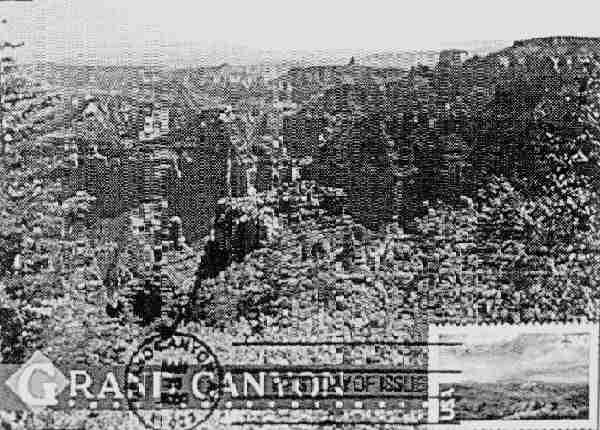
 Front Cover: On card, winter view from Mather Point on
the Grand Canyon Village. Issue: Jan-20,2000, for Scenic American Landmarks
series. Cancel: First Day, Grand Canyon AZ.
Front Cover: On card, winter view from Mather Point on
the Grand Canyon Village. Issue: Jan-20,2000, for Scenic American Landmarks
series. Cancel: First Day, Grand Canyon AZ.
 Figure 1: On card, aerial view of Grand Canyon. At the
bottom center is the Colorado river that has cut deep into the walls of the
Canyon. To the left is South Rim marked by the Yaki Point and the El Tovar
hotel at the Grand Canyon Village. To the right on the very top is the
Kaibab Plateau of the North Rim. In front of it the various formations, such
as Cheops Pyramid, Buddha Temple, Isis Temple, and in particular Shiva Temple,
site of the camp of the Expedition of the Museum of National History in 1937,
that studied the isolated wildlife of 275 acre "Sky Island". Issue:
Oct-12,1990, for the Americas. Cancel: Feb-26,1994, Grand Canyon AZ, concordant
illustration (triple).
Figure 1: On card, aerial view of Grand Canyon. At the
bottom center is the Colorado river that has cut deep into the walls of the
Canyon. To the left is South Rim marked by the Yaki Point and the El Tovar
hotel at the Grand Canyon Village. To the right on the very top is the
Kaibab Plateau of the North Rim. In front of it the various formations, such
as Cheops Pyramid, Buddha Temple, Isis Temple, and in particular Shiva Temple,
site of the camp of the Expedition of the Museum of National History in 1937,
that studied the isolated wildlife of 275 acre "Sky Island". Issue:
Oct-12,1990, for the Americas. Cancel: Feb-26,1994, Grand Canyon AZ, concordant
illustration (triple).

 Figure 2: On card, view from the Grand view Point about
10 miles by air - or 16 miles by mule up the river from the Bright Angel Trail,
showing the river and the various pyramideal formations. Issue: Oct-12,1990,
for the Americas. Cancel: may-29,1992, grand Canyon AZ.
Figure 2: On card, view from the Grand view Point about
10 miles by air - or 16 miles by mule up the river from the Bright Angel Trail,
showing the river and the various pyramideal formations. Issue: Oct-12,1990,
for the Americas. Cancel: may-29,1992, grand Canyon AZ.
 Figure 3: On card: view from the Moran Point on the East
Rim. named for the pioneer painter of the Canyon Thomas Moran. One only needs
a glimpse to realize the astonishing beauty and coloring which so delighted
the artist. issue: Oct-12,1990, for the Americas. Cancel: May-29,1992, Grand
Canyon AZ.
Figure 3: On card: view from the Moran Point on the East
Rim. named for the pioneer painter of the Canyon Thomas Moran. One only needs
a glimpse to realize the astonishing beauty and coloring which so delighted
the artist. issue: Oct-12,1990, for the Americas. Cancel: May-29,1992, Grand
Canyon AZ.
 Figure 4: The imperforated stamps of this old M.C. of the
Grand Canyon are part of the first National parks series. Issue: Mar-15,1935.
Cancel: Apr-25, 1935, Grand Canyon AZ.
Figure 4: The imperforated stamps of this old M.C. of the
Grand Canyon are part of the first National parks series. Issue: Mar-15,1935.
Cancel: Apr-25, 1935, Grand Canyon AZ.
Figure 5: On card, view of the Granite Gorge from the
Bright angle Trail on the South Rim. Issue: Jan-20,2000. for scenic American
Landmarks series. Cancel: First Day, Grand Canyon AZ.

|

|

|

|
 The Anasazi Indians may have inhabited the area as early
as 500 AD. Spaniards from Francisco Vasquez de Coronado's expedition in 1540
were the first white men to discover the Canyon. In the 1840's trappers, Indians,
and Mormon settlers knew the lay of the land and had discovered crossing points
on the Colorado River, but the Canyon was virtually unexplored. It would not
be untill 1869 that Major John Wesley Powell a Civil war veteran, would take
tem men, the 200 miles plus, length of the Canyon by boat on the Colorado River
(see: Figure 6).
The Anasazi Indians may have inhabited the area as early
as 500 AD. Spaniards from Francisco Vasquez de Coronado's expedition in 1540
were the first white men to discover the Canyon. In the 1840's trappers, Indians,
and Mormon settlers knew the lay of the land and had discovered crossing points
on the Colorado River, but the Canyon was virtually unexplored. It would not
be untill 1869 that Major John Wesley Powell a Civil war veteran, would take
tem men, the 200 miles plus, length of the Canyon by boat on the Colorado River
(see: Figure 6).
The Grand Canyon become a National Park in 1919 (see: figure 7).
Today, over five million people visit the Grand Canyon each year and it can be
extremely crowded in the summer. Most visitors see the Canyon from Grand Canyon
Village and the South Rim as this section of the park is most accessible to
population centers. Also, the North Rim is closed in the winter. The elevation
at the south Rim is 1200 feet below that of the North Rim. The climate, vegetation,
and wildlife are somewhat different on each rim. The South Rim is warmer and
more arid. On my last visit to the Grand Canyon, I chose to visit the less
crowded North Rim (see: Figure 8). While I had camped for three weeks in the
Four Corners Region (where the four States: New Mexico, Colorado, Utah, and
Arizona meet), visiting Bryce Canyon, Zion, Arches, Capital Reef, and Mesa
Verde National Parks. I was only able to spend three hours at the Grand
Canyon.
 |
 |
May-19-1999 Grand Canyon AZ |
Feb-03-1999 Grand Canyon AZ |
The weather and my not having made reservations for the
campground were the reasons for my short visit. but I do not feel cheated
because in my short visit, I was able to witness one of the largest thunderstorms
I have ever seen. The storm slowly came down the length of the Canyon toward
our vantage point at Bright Angel Point.The sky was black towards the storm,
broken by spectacular lightening flashes, accompanied by tremendous peels of
thunder that reverberated down the length of the Canyon. it was sights and
sounds that I will never forget.
Grand Canyon Village and the North Rim both have post
offices. The post office at Grand Canyon Village periodically issues pictorial
postmarks. An example of such pictorial postmark is that on Figure 1. The Max.
Cards (and their write ups) used in this article are from your editor. The OLD
M.C. is from the collection of your President.
 |
 |
Feb-26-1994 Grand Canyon AZ |
Jan-20-2000 Grand Canyon AZ |
Figure 6: On stamp, John Wesley Powell and his men on boats
on the Colorado river. On card, a view of the Grand Canyon from Powell Memorial
Point on the south Rim, Just west of the village. Issue: Aug-01,1969. Cancel:
First Day, Page AZ by the Colorado river near the border with Utah.
Figure 7:The stamp of this M.C. marks the establishment
of the Grand Canyon as a National Park in 1919. Issue: Feb-03, 1998 for the
1920's Celebrate the Century series. Cancel: First Day, special, Grand Canyon
AZ.
Figure 8: On card, a view from the Imperial Point on the
North rim (Northeast of the Grand Canyon Lodge) looking Southeast. This is the
highest point on the rim at 8801 feet. In the foreground red maple tree leaves
add to the myriad of colourful cliffs and buttes. Issue: Jan-20,2000, for
Scenic American Landmarks series. Cancel: First day, grand Canyon AZ.

|

|
|

Grand Canyon Visitord Guide
A Trip Through the Grand Canyon
Grand Canyon Tourist Center
grand Canyon Explorer
Grand Canyon River Running

|
Grand Canyon, AZ |
Britanica OnLine 1
Britanica OnLine 2
Encarta OnLine 1
Encarta OnLine 2
Encyclopedia.com
Knowledge Adventure 1
Knowledge Adventure 2
Infoplease.com


Editor: George Constantourakis |
Webmaster: Itzhak Shdemati
Last Updating: Apr-18-2000

|Royal 01|
Espana 00|
France 99|
China 99|
|Canyon|
Old MCs|
Cinema|
Waterfalls|
Owls|
Eagles|
Medicine|
President|
Gallery|
|Links .|
Club .|
Index .|