Clouds
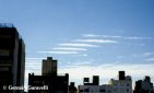
Low Level Clouds
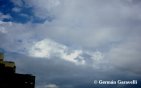
Cumulus Congestus
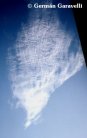
14/06/2000 -- Rosario, Argentina
Single cumulus congestus view through a disipating fog layer.
Medium Level Clouds
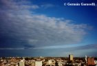
Altocumulus
04/03/2000 -- Corral de Bustos, Argentina
These are thick altocumulus next to a storm. See how the rays of the sun (cloud rays in this case) make a courious efect on the clouds. Looking to the W.
**
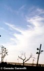
1?/03/2000 -- Rosario, Argentina
Altocumulus clouds. Notice the small undulatus part on the top. Looking to the N.
**
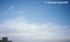
29/05/2000 -- Rosario, Argentina
Extense layer of altocumulus. Observe the lonely stratocumulus below it. Looking to the S.
Altocumulus Undulatus
20/06/2000 -- Rosario, Argentina
This altocumulus were seen in a very windy day, and because of the wind in the medium layer they have this courious look. Looking to the S.
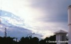
Altocumulus Mammatus
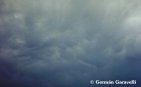
20/01/2000 -- Mar del Plata, Argentina
This altocumulus mammatus appeared after a strong storm that passed over very quickly.
**
03/03/2000 -- Rosario, Argentina
This photo was taken to the N. These altocumulus mammatus were in a storm of which I took several photos (You can recognize them because they were the only ones I took that day).
High Level Clouds
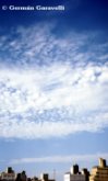
Cirrocumulus
26/04/2000 - Rosario, Argentina
Notice the small undulatus part.
**
26/04/2000 - Rosario, Argentina
Looking to the SE. Again, notice the undulatus part.
Convective Clouds
27/02/2000 -- Rosario, Argentina
Looking to the E. This CB Incus may be the one that produced lightning the night before.
**
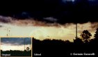
03/03/2000 -- Rosario, Argentina
This photo was over-exposed so I had to edit it. It is looking to the NW. This are the CB Incus next to the mammatus.
Lightning -- Optical Efects / Sunsets -- Precipitation