
*Major Hurricanes to enter Georgia, South Carolina, and North Carolina.
(1900 - 2008).

Building damage and beach overwash along the North Carolina coast after Hurricane Fran in 1996. Fran had sustained winds of 115-mph (gusts 140-mph) and a tides 12- feet above normal (Photo courtesy of North Carolina State Fisheries Unit - 1996).
* Major Hurricane = sustained winds 111-mph or higher/pressure below 28.50 in (965 mb).
|
Storm |
Lowest
Pressure/
Sustained Winds |
Areas
Affected
|
Rank
|
|---|---|---|---|
|
27.58/934
Mb - 140-Mph.
|
South
Carolina.
|
1
|
|
|
10/15/1954-Hazel.
|
27.70/938
Mb - 125-Mph. #
|
South
Carolina/North Carolina.
|
2
|
|
9/27/1985-
Gloria.
|
27.83/942
Mb - 105-Mph. #
|
North Carolina.(Brushed Outer Banks).
|
3
|
|
9/11/1906.
|
27.97/947
Mb -
|
North
Carolina/South Carolina.
|
4
|
|
9/13/1944.
|
27.97/947
Mb -
|
North
Carolina.
|
4
|
| 9/12/1984-Diana. | 28.02/949 Mb - 130-Mph. | North Carolina (Cape Fear only). |
5
|
|
9/29/1959-Gracie.
|
28.05/950
Mb - 120-Mph.
|
South
Carolina.
|
6
|
|
28.17/954
Mb - 115-Mph.
|
North
Carolina.
|
7
|
|
|
9/13/1933.
|
28.26/957
Mb -
|
North
Carolina.
|
8
|
|
8/31/1993-Emily.
|
28.35/960
Mb - 115-Mph.
|
North
Carolina. (Brushed Outer Banks).
|
9
|
| 9/11/1960-Donna. | 28.35/960 Mb - 105-Mph. # | North Carolina. |
9
|
| 9/19/1955-Ione. | 28.35/960 Mb - 100-Mph. # | North Carolina. |
9
|
| 8/12/1955- Connie. | 28.41/962 Mb -100-Mph. # | North Carolina. | 1010 |
|
Map of major hurricanes to strike Georgia, South Carolina, and North Carolina (1900- 2006). |
|||
Since 1900 thirteen major hurricanes have made landfall along the North and South Carolina coast. Only two storms since 1900 were category 4 hurricanes at landfall - Hazel in 1954, and Hugo in 1989. Coastal Georgia, however, has not experienced a major hurricane landfall in over one hundred years. However, records show that South Carolina and Georgia experienced several destructive tropical cyclones since colonial times. In 1893, a severe storm killed two thousand people near Savannah and Hilton Head Island. It seems favorable storm tracks may have spared Georgia in recent decades. The 1950's were the most active period on record along the North and South Carolina coast (NOAA).
Hurricanes that strike Georgia and the Carolinas usually originate in the Atlantic Ocean east of the Bahamas. Many hurricanes that track north of the Greater Antilles eventually threaten this portion of the southeastern United States. Periodically, storms in the eastern Gulf of Mexico, pass over the Florida peninsula, and move up the Atlantic coast toward the Carolinas. Old fronts that sit over the subtropical waters off the southeast U.S. Atlantic coast, occasionally will develop in tropical cyclones. Many of the largest and most intense tropical cyclones to strike the southeastern United States have long tracks covering thousands of miles.
Hurricanes Hugo (1989) and Hazel (1954) were by far the most intense and destructive hurricanes to strike the region in the last one hundred years. Hurricane Hazel slammed into the coast between North and South Carolina with incredible fury. The beaches of Brunswick County North Carolina were leveled by a 16-foot storm surge. Hurricane Hugo hit coastal South Carolina in much the same manner in 1989 - leaving untold sorrow and destruction. Hugo was the most intense topical cyclone to ever strike the U.S. Atlantic coast north of Florida. Hugo claimed 36 lives in the United States and was the most costly hurricane ever up to that time - $7-billion in property damage in 1989 dollars (see Hugo page).
The physical geography of the United States Atlantic coastline often influences where a tropical cyclone hits. The Atlantic coast of Georgia is orientated north to south. For a tropical cyclone to cross the Georgia coast and move directly inland, it must be moving due west in the Atlantic - an unusual path. Starting around Hilton Head Island, South Carolina - the Atlantic coast extends east into the ocean. The northeastern portion of the South Carolina coast is furthest east, and somewhat at a higher risk than the counties to the south. Eastern North Carolina has the highest risk from a hurricane landfall. With the exception of the Florida Keys, the North Carolina Outer Banks have the shortest return period for hurricane force winds in the United States. The Outer Banks thrusts out into the Atlantic Ocean - into the path of recurving storms. For this reason, the Outer Banks is frequently brushed by northeastern moving storms.


LEFT: Hurricane Hugo makes landfall in South Carolina with 140-mph winds and a record 20-foot storm tide in 1989 (Photo NOAA).
RIGHT: Surf City, North Carolina after Hurricane Fran in 1996 (Photo WSOC).
Little is known about the major hurricane of 1906 that came inland near Georgetown, South Carolina. The storm was said have caused a small area of very severe damage. Still, less is known about the intensity - the only direct measurement made during the storm was a pressure of 27.97 inches. Maximum wind gusts in Wilmington, NC were measured at only 50-mph. It appears this storm was quite small but intense. Damage was heavy from North of Charleston to the Myrtle Beach area.
The hurricane of 1933 was a major hurricane when it struck the North Carolina coast near Morehead City. A severe storm-surge accompanied the storm - sweeping away coastal buildings from both the Atlantic coast and shore of southern Pamlico Sound. Twenty-one people were killed, and damages were estimated at $3 million - an immense sum in the 1930's. Tides were reported to be 15-feet above mean sea level - with accounts of people retreating to the attic on Ocracoke Island and New Bern to escape the storm surge. Sustained winds of 92-mph were measured at Cape Hatteras until the anemometer was destroyed.
A major hurricane known as the Great Atlantic Hurricane of 1944 passed just to the east of Hatteras Island in September 1944. The Outer Banks was said to have suffered great destruction, and extensive tidal flooding. More than one-hundred buildings between Hatteras and Avon were swept off the foundations by the waters of Pamlico and Albemarle Sounds. At the Cape Hatteras Weather Station, a surface pressure of 27.97 inches (947 mb) was recorded. This is still considered the lowest surface pressure ever recorded on land along the Outer Banks. Several other wind and pressure recordings from North Carolina - confirm that the 1944 Hurricane was of considerable intensity.
Hurricane's Connie and Ione (1955) struck North Carolina in the Cape Lookout area with similar effects. Both storms were moving at greater than 30-mph when they struck the coast - thus they were classified as weak Category 3 hurricanes at landfall. Connie was a borderline major hurricane when the center crossed the coast on September 12 near Morehead City. A barometric pressure of 28.40 in (962 mb) was measured at Fort Macon with peak gusts over 100-mph. Although wind damage from Connie was light, the cyclone dumped torrential rain across the region. Ione crossed the North Carolina coast as a stronger storm, with pressure reports of 28.00 in (949 mb) close to the eye. Ione also dumped heavy rain - up to 16-inches in 24-hours across eastern North Carolina. The New Bern area was hard hit, with a forty-block area of the city submerged. Ione was responsible for five deaths in North Carolina.
Hurricane Donna (1960) was one of the worst cyclone disasters in North Carolina history up to that time. Donna was a severe Cape Verde storm that traveled across south Florida, then curved over central Florida and came up the Atlantic coast. Donna, like Connie and Ione, was a boardline major hurricane when the eye crossed the coast near Topsail Island. A barometric pressure of 28.35 inches (960 mb) was measured along with gusts near 120-mph. Donna did severe damage in the Morehead City, Atlantic Beach, and Beaufort areas. The Outer banks also suffered some of the worst damage ever recorded in the region. Gusts estimated at over 120-mph tore off roofs, while the storm surge flooded many sounside communities. Eight people were killed during Donna in North Carolina. Tragically - three of those killed in North Carolina were a group of young boys who had taken shelter in an oceanfront home that was swept away by the storm-surge.
Twenty - five years after Donna hit North Carolina, Hurricane Diana (1984) was the disaster that might have been. Diana stalled for several days in early September 1984 - just south Cape Fear, North Carolina. When Diana was only about 15-miles off the North Carolina coast, sustained winds reached 130-mph. The central pressure of 28.02 inches (949 mb) was recorded by aircraft just after the storm reached its peak. Fortunately, the hurricane lost much of its intensity as it stalled just to the south of Cape Fear. By the time Diana had made landfall, the winds had dropped to 90-mph. The Oak Island Coast Guard Station measured sustained winds of 115-mph when Diana was at it's peak intensity 20 miles offshore.
Although Hurricane Gloria (1985) was almost a category five hurricane at one point (winds reached 150-mph), the storm weakened as it approached the United States mainland. Although the eye of the hurricane passed over Hatteras, the strongest part of the storm remained at sea. Sustained winds on the Outer Banks were only around 75-mph, with gusts to 100-mph. The Diamond Shoals light tower sixteen-miles offshore, recorded winds of 98-mph with a gust to 120-mph. Gloria produced little significant damage on the Outer Banks. Hurricane hunters recorded very low barometric pressure when the eye of Gloria was about 5-miles east of the Outer Banks; 27.83 inches (942 mb). Hatteras reported a barometric pressure of 28.00 inches (948 mb).
Hurricane Emily (1993) brought the worst major hurricane conditions to the Outer Banks since Donna in 1960. Emily approached the Outer Banks with sustained winds of 115-mph, then recurved to the northeast. While the eye was about 20 miles offshore, winds of 100 mph, with gusts to at least 120-mph, raked the Outer Banks. The intense winds snapped one hundred foot pines, overturned mobile homes, and ripped the roofs off several buildings. Emily hit at the high astronomical tide. Tides of 2 - 3 feet above normal flooded the Cape Hatteras and Buxton areas. The new Cape Hatteras School had three-feet of ocean water in classrooms, destroying the schools computer center and library. 553 homes suffered more than 50% damage on Hatteras Island. Total damage on Hatteras Island is estimated at $35 million.
In 1996 Hurricane Fran slammed into southeastern North Carolina near Wrightsville Beach in September 1996. Fran was the first major hurricane to make a direct hit on North Carolina since Donna in 1960. Twenty-six lives were lost, many due to the heavy inland rains. Farn caused immense storm surge flooding along 50-miles of the North Carolina coast. Hurricane Fran is the the most expensive hurricane in the history of North Carolina (see Fran Page).


LEFT: Hurricane Emily (1993) approaches the North Carolina Outer Banks with 115-mph winds.
RIGHT: Residents flee storm-surge waters as Hurricane Alex (2004) passes offshore of the North Carolina coast (Photo RNAO).
SOUTH ATLANTIC COAST HURRICANE INTENSITY
Since 1900 the most intense hurricanes to strike Georgia and the Carolinas had barometric pressure readings in the 27.58 to 27.70 inch range (934 - 938 mb). Worldwide - landfalling tropical cyclones with a barometric pressure of less than 28.00 inches (949 mb) are rare. Of the thirteen major hurricanes to strike the Carolinas since 1900 - only five made landfall with a pressure below 28.00 inches. Hurricane Hugo's landfalling pressure of 27.58 (934 mb) is the lowest known barometric pressure reading ever measured along the Atlantic coastline of the United States (north of Florida).
Wind speeds is less reliable than using barometric pressure to determine hurricane intensity. Wind speeds are given in sustained winds (the average of 1-minute of wind). Peak wind gusts may exceed sustained winds by as much as 25%. Until the late 1950's when hurricane hunters routinely measured winds in a landfalling hurricane - winds speeds were estimated.
The hurricanes of 1906 and 1944 may have had sustained winds of 120-mph, but few direct measurements were made during these storms. The 1933 hurricane, Gracie (1959), Emily (1993), and Fran (1996) all had sustained winds of similar value - about 115-mph. Peak winds gusts in each of these storms was in the range of 130 to 140-mph. A gust of 138-mph was measured during Hurricane Gracie in Beaufort, South Carolina. During Hurricane Fran, a gust of 137-mph was measured from a roof-top anemometer 30-feet above ground in Hewletts Creek in Wilmington, North Carolina (NWS - 1996). Hurricane Diana (1984) fortunately never crossed the coast when the winds were at maximum intensity (sustained at 130-mph).
The sustained winds in Hazel (1954) were around 125-mph when it crossed the coast near Little River, South Carolina. However, Hazel's rapid forward speed of 32-mph increased the sustained winds on the right-hand side of the storm to stronger values. Peak gust in Hazel have been estimated at around 155-mph along the North Carolina beaches. When Hurricane Hugo crossed the South Carolina coast in 1989, hurricane hunter aircraft reported sustained winds of 140-mph. The Ship "Snow Goose" was anchored in the Sampit River a few miles from Georgetown and measured sustained winds of 121-mph. This measurement appears to be the strongest near-surface sustained winds ever measure on land in Georgia or the Carolinas. Peak wind gusts in Hurricane Hugo may have been as high as 165-mph.

Hurricane Diana (1984) was one of the most intense tropical cyclones to ever threaten the United States Atlantic coast in the last 50-years. This satellite photo shows the classic eye of the storm just to the southeast of Cape Fear, North Carolina with 130-mph winds. Fortunately Diana weakened greatly before landfall in North Carolina (Photo courtesy of NOAA).
Over the last twenty-five years there has been a significant increase in the amount of development in the coastal areas of Georgia and the Carolina's. The subtropical climate of coastal Georgia and South Carolina has drawn residents from the northern United States and Europe seeking retirement homes in a mild climate. Coastal Georgia has experienced significant population growth on the islands, and around Savannah. As of 2003, the combined amount of insured property in the coastal counties of the three states, was more than $185 billion dollars (IIPLR - 2003 ). This figure, only represents insured property located in a county that is directly on the Atlantic coast. In this region, landfalling tropical cyclones can remain intense up to one-hundred miles inland. Hazel (1954), Hugo (1989), and Fran (1996), charged through the inland counties with shocking force. The warm subtropical ocean waters off the South Carolina and Georgia coast, may even intensify a landfalling hurricane just before the eye crosses the coast.
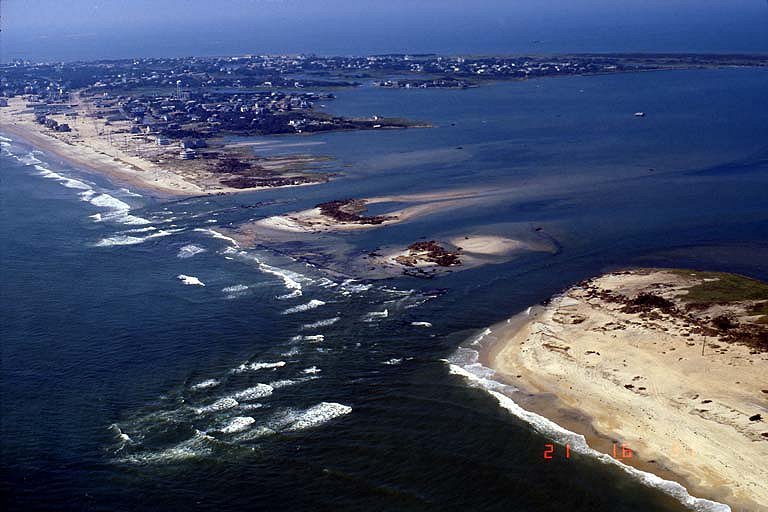
In 2003 - Hurricane Isabel made landfall along the North Carolina coast near Hatteras. Isabel had sustained winds of 105-mph and and a pressure of 28.26 inches (957 mb). Although not a major hurricane at landfall - Isabel's 10-foot storm surge caused significant beach erosion and coastal damage along the Outer Banks of North Carolina. Isabel even created a new inlet through Hatteras Village (above). Telephone poles along road are just visible in lower right-hand corner
(Photo NOAA Ocean Services - 2004).
© Michael A.Grammatico 6/04
