

Major Hurricanes to enter the Gulf Coast
(1900 - 2008).
DESTRUCTIVE GULF COAST HURRICANES - 105 YEARS APART.
LEFT: The Sacred Heart Church on Galveston Island, Texas after the 1900 hurricane. Four- hundred people survived the night behind its stone walls - 6,000 others perished.
RIGHT: New Orleans, Louisiana lies flooded and battered one day after Hurricane Katrina. Katrina was responsible for 1500 deaths in Louisiana and Mississippi (Photos NOAA).
* Barometric pressure under 28.50 inches (965 mb)
|
Storm |
Lowest
Pressure/
Sustained Winds |
Areas
Effected
|
Rank
|
|---|---|---|---|
|
26.84/909
mb - 190-Mph.
|
Mississippi. |
1
|
|
| 8/29/2005 - KATRINA. | 27.18/920 mb - 125-Mph. | Louisiana/Mississippi. |
2
|
|
9/11/1961-
CARLA.
|
27.49/931
mb - 140-Mph.
|
Texas.
|
3
|
|
9/29/1915.
|
27.49/931
mb -
|
Louisiana. |
3
|
|
9/20/1909.
|
27.49/931
mb -
|
Louisiana.
|
3
|
|
9/9/1900.
|
27.64/936
mb -
|
Texas.
|
3
|
| 9/24/2005 - RITA. | 27.37/937 mb - 115-Mph. | Texas/Louisiana. |
4
|
|
8/15/1932.
|
27.79/941
mb -
|
Texas.
|
5
|
|
27.83/942
mb - 115-Mph.
|
Florida Panhandle
|
6
|
|
|
6/27/1957
AUDREY.
|
27.91/945
mb -
|
Louisiana.
|
7
|
|
8/3/1970-
CELIA.
|
27.91/945
mb - 125- Mph.
|
Texas.
|
7
|
| 8/16/1915- | 27.91/945 mb - | Texas |
7
|
| 8/9/1980 - ALLEN.. | 27.91/945 mb - 115-Mph. | Texas |
7
|
| 9/11/1979 - FREDERIC. | 27.94/946 mb - 130- Mph. | Alabama. |
8
|
| 9/16/2004 - IVAN. | 27.94/946 mb - 120- Mph. | Alabama/Florida Panhandle | 77777 8 |
| 7/10/2005 - DENNIS. | 27.94/946 mb - 120- Mph. | Florida Panhandle. |
8
|
| 9/9/1965 - BETSY. | 27.99/948 mb - 125-Mph. | Louisiana. |
9
|
| 9/17/1916- | 27.99/948 mb - | Texas. |
9
|
| 7/6/1916. | 27.99/948 mb - | Alabama |
9
|
| 9/7/1933. | 28.03/949 mb - | Texas. |
10
|
| 9/20/1967-BEULAH. | 28.05/950 mb - 120-Mph. | Texas. |
11
|
| 10/3/1964 - HILDA. | 28.05/950 mb - 115-Mph. | Louisiana. |
11
|
| 8/30/1942. | 28.05/950 mb | Texas. |
11
|
| 8/23/1999 - BRET. | 28.08/951 mb - 115-Mph. | Texas. |
12
|
| 9/8/1974 - CARMEN. | 28.11/952 mb - 120-Mph. | Louisiana. |
13
|
| 9/23/1975 - ELOISE. | 28.20/955 mb - 125-Mph. | Florida Panhandle |
14
|
| 9/30/1926. | 28.20/955 mb - | Louisiana. |
14
|
| 9/1918. | 28.20/955 mb - | Louisiana. |
14
|
| 8/26/1992 - ANDREW. | 28.23/956 mb - 115-Mph. | Louisiana. |
15
|
| 9/1941. | 28.29/958 mb - | Texas. |
15
|
| 9/1917. | 28.29/958 mb - | Florida Panhandle |
15
|
| 9/1909. | 28.29/958 mb - | Texas. |
15
|
| 9/24/1906. | 28.29/958 mb - | Alabama/Mississippi. |
15
|
| 9/2/1985 - ELENA. | 28.32/959 mb - 115-Mph. | Alabama/Mississippi. |
16
|
| 8/18/1983 - ALICIA. | 28.41/962 mb - 115-Mph. | Texas. |
17
|
| 9/11/1934. | 28.41/962 mb - | Louisiana. |
17
|
| 9/6/1936. | 28.47/964 mb - | Florida Panhandle |
18
|
| 9/19/1947. | Pressure Unknown | Louisiana. |
Unknown
|
| 9/20/1926. | Pressure Unknown | Alabama. |
Unknown
|
| 9/16/1919. (Cat 4) | Pressure Unknown | Texas. |
Unknown
|

Since 1900, forty major hurricanes have crossed the Gulf Coast (from Texas to the Florida Panhandle). Seven were of category four intensity (1900, 1919, 1915 (2), 1932, 1957, 1961). Hurricane Frederic (1979) and Hurricane Katrina (2005) were close to category four intensity at landfall. Only one category five hurricane has ever struck the Gulf coast - Camille in 1969. There have been two significant periods of heightened tropical cyclone activity in the Gulf states. The first peak occurred from 1900 to 1920, when eleven major hurricanes crossed the Gulf coast. The second peak, occurred from 1960 to 1980, when ten major hurricanes crossed the Gulf coast.
Hurricanes that impact the Gulf states usually approach the region through the northwestern Caribbean Sea. Some of the largest and most intense hurricanes to strike the Gulf coast originate thousands of miles away in the deep tropical Atlantic. Many storms that impact the Gulf states, also develop in the Gulf of Mexico itself. Hurricanes that strike the Florida Atlantic coast, occasionally pass completely over the peninsula - and strike one of the Gulf states. When this occurs, Louisiana or Texas are the preferred targets. Hurricane Andrew in 1992 was a recent example of this.
The 1900 Galveston Hurricane, Hurricane Camille (1969), and Hurricane Katrina (2005) are the three most devastating tropical cyclones to strike the Gulf coast over the last one-hundred-five years. The 1900 Galveston storm was the worst human disaster in American history - 6,000 lives lost. The city of Galveston was leveled with frightening intensity. Hurricane Camille was a small, but super intense cyclone. Camille's tidal surge remains a record for height and inland penetration in the United States. Although the strongest measured wind gust during Camille was 172-mph - several estimates place peak winds in Camille at 215 to 220-mph. Hurricane Camille remains the strongest tropical cyclone to ever enter the United States mainland (see Camille page).
Tragically, in 2005 - the Gulf coast was once again the site of a horrific tropical cyclone disaster - Hurricane Katrina struck the Louisiana and Mississippi coast with terrible consequences. As of early 2006 - at least 1,336 people were known to have died in the cyclone. The total amount of damage is estimated at a staggering $75 billion. Hurricane Katrina is now - by a considerable margin - the worst natural disaster ever experienced in the United States (see Katrina page).


LEFT: The eye of Hurricane Katrina hits the coast of Louisiana near Buras in August 2005. Katrina was a large and intense tropical cyclone. RIGHT: Residents of New Orleans try to stay above rising waters on Canal Street. (Photo Courtesy NOAA).
In 1961, Hurricane Carla struck the Texas coast with winds estimated at 140-mph (gusts 170-mph). Hurricane Frederic (1979) slammed into the Alabama coastline with 130-mph winds. Frederic was the most expensive hurricane in U.S. history until Hugo in 1989 (see Frederic page). Hurricane Alicia (1983) and Opal (1995) were of the same general intensity at landfall (sustained winds 115-mph), while property damage and economic impact were similar.
In 2004, Hurricane Ivan hit the Alabama and Florida Panhandle coast in much the same manner as Frederic in 1979. Ivan was one of the three most significant hurricanes to hit the Alabama coast in more than 100-years. Only Frederic and the 1926 hurricane were as destructive. Thousands of homes in the three-county coastal area of Baldwin, Escambia, and Santa Rosa were damaged or destroyed. Ivan left a trail of damage and sorrow across the Caribbean and southeastern United States. The effects of Ivan were felt across a 4,000-mile track from Barbados to Nova Scotia (see Ivan page).
In 2005 the United States mainland was again battered by tropical cyclones. Three major hurricanes (Dennis, Katrina, Rita) struck the Gulf coast. The 2005 cyclone season broke all records for the number of hurricanes, and the most intense hurricane of ever measured.


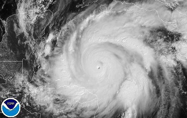
LEFT: Inferred satellite photograph of Hurricane Ivan - 100-miles south of the Alabama coast on September 16th, 2004. At the time of this photo Ivan had sustained winds of 135-mph and a barometric pressure of 27.49 inches (931-mb). RIGHT: Orange Beach, Alabama suffered extensive damage from Ivan's 10 to 15-foot storm surge. (Photos Courtesy NOAA/NWS Mobile-2004).
GULF COAST HURRICANE INTENSITY
Since 1900 the most intense hurricanes to strike the Gulf coast had barometric pressure readings in the 27.49 to 27.91 inch range (931 - 945-mb). Hurricane Camille (1969) is separated from this group due to its extreme intensity. Worldwide - landfalling tropical cyclones with a barometric pressure of less than 28.00 inches (949 mb) are rare. Of the forty major hurricanes to cross the Gulf coast since 1900 - only nineteen made landfall with a pressure below 28.00 inches. Recent historical research has uncovered evidence that the Great Hurricane of 1919 may have had a landfalling pressure below 28.00 inches in Texas. The 26.84 inch (909Mb) barometric pressure reading taken in Bay St. Louis, Mississippi during Hurricane Camille - is the lowest sea level pressure ever measured in a landfalling hurricane along the Gulf coast. Only during the 1935 Florida Keys hurricane was a lower barometric pressure recorded (26.35 inches/892 Mb).
Over the open sea - a few hurricanes, and supertyphoons in the Western Pacific, have had barometeric pressurs measured below 900 mb (26.60 inches) In 2005, a new record low barometric pressure was measured in Hurricane Wilma - 26.06 inches (882 mb), in the very active 2005 hurricane season. The World record is 25.90 inches (870 mb) in Supertyphoon Tip in 1979. Sustined winds in these super tropical cyclones have been measured at speeds approching 200-mph. However, only since the late 1940's have scientist had the ability to accurately make these measurements.
Wind speed is less reliable than using barometric pressure to determine hurricane intensity. Wind speeds are given in sustained winds (the average of 1-minute of wind). Peak wind gusts may exceed sustained winds by as much as 25%. Until the late 1950's when hurricane hunters routinely measured winds in a landfalling hurricane, winds speeds were estimated.
Hurricane Frederic had sustained winds of 130-mph (gusts 155-mph), when it crossed the Alabama coast in 1979. Hurricane Katrina (2005), is estimated to have had sustained winds of 125-mph when the center first hit the Louisiana coast. The sustined winds in the Hurricanes of 1909, 1915, and Hurricane Carla (1961), are estimated to have been around 140-mph, with peak gusts in the 165 to 170-mph range. Scientists aboard a reconnaissance aircraft measured 140-mph sustained winds in Hurricane Carla just before the center crossed the Texas coast. During Carla, Port Lavaca recorded a gusts as high as 153-mph - until the anemometer blew away. The sustained winds in Hurricane Camille (1969) were measured at 190-mph by hurricane reconnaissance aircraft just prior to landfall in Mississippi. Peak gusts in Camille may have reached 220-mph.
Hurricane Wilma at it's frighting peak intensity on October 19, 2005.
Hurricane Hunters measured a barometric pressure of 26.06 inches (882 Mb) and sustained winds of 185-mph (gusts 215-mph +). At the time of this satellite photo - Wilma was the most intense tropical cyclone ever observed in the Atlantic Basin. Only a few supertyphoons in the Western Pacific have been more intense. Wilma also had the smallest eye ever observed in a tropical cyclone - only 2 miles across (NOAA).

A rare view from inside the eye of Hurricane Allen on August 7, 1980. At the time this photo was taken, Allen was just entering the Gulf of Mexico through the Yucatan Channel. Scientists aboard a reconnaissance flight into the storm measured a barometric pressure of 26.55 inches (899 mb) and sustained winds of 190-mph (Photo Courtesy of NOAA Photo Library 1980).
THE GULF COAST
The subtropical climate of the Gulf states has been attracting new residents for several decades. Three of the largest metropolitan areas in the United States are now along the Gulf coast (Houston, Tampa, New Orleans). The metropolitan Houston area now has more than 3.2 million residents. Both New Orleans and Tampa have metro areas with more than 2 million people. There has been a rapid development in vacation homes along the barrier islands of the Florida panhandle and in the parishes of southern Louisiana. The combined value of insured property along the Gulf coast from Texas to the Florida panhandle is greater than $500 billion today.

Residents in coastal Mississippi stare in shock at the death and destruction left by Hurricane Katrina in 2005 (Photo USGS).
© Michael A. Grammatico 5/06