  |
~ Roman Monographies ~
Aqueducts · part III · PAGE 2 |
  |
|---|
| |
~ Roman Monographies ~
Aqueducts · part III · PAGE 2 |
|
|---|
FROM THE SPES VETUS TO THE TUSCOLANO DISTRICT
the Aqua Felix, following the route of
the early Aqua Claudia, off Aurelian's wall
After leaving Aurelian's wall by the old Spes Vetus, for about one mile the Aqua Felix follows what in ancient roman times was the course of the Aqua Claudia, along via Casilina Vecchia. The two main viaducts of the Aqua Claudia and Aqua Marcia ran parallel and almost straight, very close one to the other, and between the two existed a paved road, which acted as a service passage for their maintainance and restoration.Today via del Mandrione follows more or less the same route of the aforesaid ancient road; it starts about 500 metres (or yards) off Porta Maggiore, and divides the Casilino district from the Tuscolano district. Although the street level has considerably risen, the western side of the road is flanked by the Aqua Felix, built by the very few remains of the Aqua Claudia, while along the opposite side are the precincts of the modern railway line.
This part is not too interesting, because the ancient roman viaducts have almost completely disappeared, but the Aqua Felix is easy to follow. Care should be taken to the local traffic, since the road is narrow, and the cars often drive fast.
the Aqua Claudia in via del Mandrione
the last part of via del Mandrione: on the left
is the Aqua Felix resting against the Aqua Claudia
Where via del Mandrione comes to an end, slightly further, the Aqua Felix and the Aqua Claudia separate again, though keeping parallel directions.
A - Porta Furba B - fountain of Clement XII
Sixtus V's arch is known as Porta Furba, a name almost recalling a city gate, whose etymology is still debated.
Unfortunately, the ancient arch by which the Aqua Claudia too once crossed via Tuscolana went lost; according to historical sources it was made of white travertine marble.
Porta Furba, where the Aqua Felix crosses via Tuscolana
 the fountain of Clement XII, standing by Porta Furba |
Another interesting feature is the fountain whose grotesque face pours
water from the Aqua Felix into a small basin. This is one of three fountains that
Sixtus V had set on spots where his aqueduct met busy roads: the other two
stood in via Casilina (by Porta Maggiore) and in via Tiburtina
(by Porta Tiburtina), as a sort of refreshing welcome for travellers approaching Rome.
|
|---|
Immediately after Porta Furba, the Aqua Claudia stands again for about 150 metres (or yards). Here many of its archways have been walled up, likely during the restoration works carried out during the late empire (300-500 AD).
Here the Aqua Claudia and the no longer existing Aqua Marcia once crossed each other, reversing their respective positions. Shortly further, the Aqua Marcia gave off a branch called Aqua Antoniniana, built in the early 3rd century under Caracalla, whose purpose was to reach the emperor's great baths; one of the very few surviving fragments of this branch is the so-called Arch of Drusus by the first part of via Appia (see Aurelian's Walls, part III, page 2).
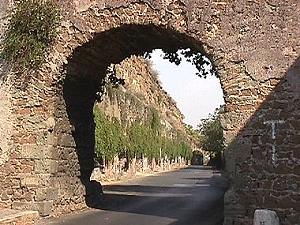
the Aqua Claudia off via Tuscolana
the Aqua Felix is seen through
an arch of the Aqua Claudia
The surviving part of the Aqua Claudia soon comes to an end, but the Aqua Felix, unbroken, keeps following one side of vicolo dell'Acquedotto Felice, a narrow though very long road named after the aqueduct, whose direction it basically follows.
Where the path comes to a junction, a short slope on the right leads to a series of eleven arches belonging to the ancient aqueduct, heavily restored; the deep rectangular prints along the pillars are the traces left by the large stones taken away in different ages, and reused for other works (in particular, for the making of the nearby Aqua Felix).
Following again the previous route, the path grows rather narrow, and after 150 metres (or yards) the Aqua Felix reaches a mediaeval tower, Torre Fiscale (once called Torre Branca).
 the Aqua Felix (left) approaching Torre Fiscale |
It was built above a second crossing of the Aqua Claudia and the Aqua Marcia. Therefore,
these two aqueducts enclosed a certain area between the tower and the aforesaid Porta Furba.
The Goths who sieged Rome in the 6th century walled up their arches and used this
area as a camp; due to this, the land between Porta Furba and Torre Fiscale was later
named Campus Barbaricus ("barbarian field").
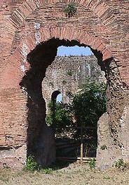
The two ancient roman structures can be told in the lower part of the tower. On the side looking westwards it is also possible to see the section of the Aqua Claudia's specus, although it is now filled up, while the upper one of the Anio Novus is no longer visible. |
 the arch of the Aqua Claudia below the mediaeval tower |
|---|
By Torre Fiscale the public pathway comes to an end, and the only possible way to go any further is to make a diversion, following on the right a road that gently slopes, winding for about 100 metres until it reaches via Appia Nuova. While walking along this road, a further stretch of the Aqua Claudia can be distinctly seen in the distance, towards the south-east.
a view of Parco degli Acquedotti, with some remains
As soon as some tall modern buildings come into sight along via del Quadraro, just past a football field, the road on the right called via di Villa Lemonia leads to Parco degli Acquedotti.
In ancient times a large villa stood where today is the park, and its few remains scattered on the grass, though very poorly preserved, make this a rather charming site.
Not far from Parco degli Acquedotti are the subway stations Lucio Sestio and Giulio Agricola (line A), that provide an easy way back to the central districts.
further remains in Parco degli Acquedotti
PAGE 1
AQUEDUCTS BY
THE CITY GATESPAGE 3
THE AQUA TRAIANA AND
THE AQUA ALEXANDRINA