

Mpumalanga Province
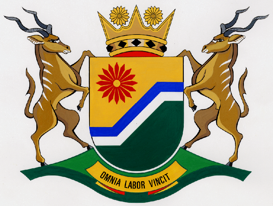
Mpumalanga, the smallest of the eight rural provinces in South Africa’s post-1994 dispensation, has arms which may be blazoned:
Arms: Per bend sinister, inclined in the flanks per fess, Or and Vert, surmounting the partition a bend sinister per bend sinister, all similarly inclined, Azure and Argent, in dexter chief a Barberton daisy Gules, seeded Or; the shield ensigned of a coronet comprising a circlet Or jewelled of lozenges sable and heightened of four rays alternating with as many Barberton daisies, Or.
Supporters: Two kudu antelope proper.
Motto: Omnia labor vincit.
Arms explained:
This coat of arms is unique among the arms of the provinces of South Africa in that it consists chiefly of geometrical forms and colours, with only one natural charge within the shield area.
I have no official explanation of the arms, only the blazon, but it would appear that the bend (the inclined part of the design) represents the descent from the Highveld plateau
to the Lowveld, while the portion “inclined in the flanks per fess” – the horizontal “ledges” on either side of the shield stand for the Highveld (sinister), the western sector of the province, and the Lowveld (dexter), on the east side.
The colours blue and argent (silver/white) would appear to represent the waters of Mpumalanga, notably the Olifants, Klaserie, Sand, Sabie, Crocodile and Komati (iNkomati) rivers, and perhaps even the Phongolo (Pongola) River, which
forms a short section of the the boundary with KwaZulu-Natal.
(There is another Crocodile River in North-West and Limpopo provinces, a tributary of the Limpopo, and there are two Olifants [elephants’] rivers in the Western Cape.)
Unlike the others listed, the Phongolo rises in KwaZulu-Natal; the rest all have their headwaters in Mpumalanga. It was formerly the Transvaal-Natal border over more than half its length, but the long tail of the Piet Retief district, on the left bank of the river, became part of KwaZulu-Natal in 1994.
These rivers run eastward; in the south of Mpumalanga there is also the Vaal River, which runs westward, becoming the Free State boundary just below Standerton and continuing as the northern boundary of the Free State adjoining Gauteng and North-West Province, before it enters Northern Cape and reaches its confluence with the Orange River just west of Kimberley.
Mpumalanga is also known for a large number of bodies of still water, most of them dams – such as the Loskop, on the Olifants River, the Grootdraai, on the Vaal, the two Doringpoort dams at Witbank – but also a series of lakes, notably Lake Chrissie at the town of Chrissiesmeer, south of Carolina.
Notable among the many routes between Highveld and Lowveld is the route taken by the first railway to enter the Zuid Afrikaansche Republiek, built from Lourenço Marques (now Maputo) by the Nederlandsch-Zuid Afrikaansche Spoorweg-Maatschappy (NZASM), which linked Waterval Onder and Waterval Boven (between Nelspruit and Belfast) by means of a rack railway tunnel built in 1893. The tunnel has long since been bypassed. The line (still the main rail route between Gauteng and Maputo) currently uses an easier gradient and has electric traction, but the tunnel itself is a national monument that can be traversed by backpackers.
The gold of the upper part of the shield would appear to symbolise the sub-tropical sun that warms Mpumalanga.
It is likely also to refer to the gold panned in several parts of the area now making up the province (notably Barberton and Pilgrim’s Rest) in the gold rush period that preceded the discovery of gold on the Witwatersrand in 1886. Unlike most of the eastern gold rush sites, Barberton has remained productive. By the 1970s it still had seven active gold mines (reef and alluvial), five asbestos mines and mines producing glassmakers’ sand, nickel, arsenic, mercury, magnesite, barytes and germanium.
The green of the lower part represents the fertile land of Mpumalanga.
The flower is a head of the Barberton daisy, Gerbera jamesonii, a member of the family Compositæ which is endemic in Mpumalanga and Limpopo Province. The flowers are up to 90 mm in diameter. Their natural colour is a bright red, but cultivars now exist in a variety of colours, as well as in composite form. It is also one of Mpumalanga’s best exports (albeit sadly bringing little income to the province), having proved popular in gardens across not only South Africa but Europe and the Americas, too. The species was named in honour of 19th-century amateur botanist R Jameson, who took a specimen from Barberton to the Durban Botanic Garden. From there it was sent to Kew, in London, where the species was scientifically described.
The Barberton daisy (sometimes called the Transvaal daisy) was the badge (usually on a pale blue background) of several Northern Transvaal (Pretoria-based) sporting associations, notably the Northern Transvaal Rugby Union. Mpumalanga’s claiming of the symbol is appropriate, because this species is not entirely at home on the Highveld, and has to be protected against frost in Gauteng gardens.
The term “seeded” means that the actual inflorescence or head of the flower is in the colour mentioned (or, meaning gold or yellow).
The daisy’s position in the design also suggests the sun, and reinforces that aspect of the gold sector of the field.
The crest resembles an Oriental crown (as it is named in heraldry), which usually is a succession of triangular spikes. In this instance every other spike has been replaced by a golden Barberton daisy.
The black (sable) lozenges (“diamonds”) in the circlet of the crown probably represent the bituminous coal wealth of Mpumalanga. The coalfields of the Eastern Highveld (western Mpumalanga) are among the world’s richest. Two immense power stations are powered solely by the coal produced by adjacent mining operations, and the oil-from-coal plant at Secunda is the world’s largest. (Secunda is so called because it was the second built by the Sasol Corporation, which has its older but also immense chemical works at Sasolburg in the Free State.)
The supporters are a pair of kudu bulls (Tragelaphus strepsiceros). These large antelope are endemic in those parts of the province where game animals are still found wild, notably the Kruger National Park, of which the southern half falls into Mpumalanga, and in the many private game reserves that adjoin the Kruger Park. Technically this animal is called the greater kudu. It stands about 130 cm tall at the shoulder and is found in hilly bush country or open woods in Southern and Eastern Africa. It is noticeably taller than the lesser kudu (Tragelaphus imberbis, 100 cm tall at the shoulder), which is a native of East Africa.
Northern Cape has a kudu for its sinister supporter.
An additional reason for using kudu as supporters could be that a kudu head appears in the arms of the National Parks Board.
The motto, Omnia labor vincit, translates as “Labour will conquer all”. This could merely indicate the importance of hard work, or it might indicate the socialist tendencies of the ruling party in the provincial government.
The province is currently the only one in South Africa that has its own flag; it is a banner of the arms.
About the province:
The province formally came into being on 27 April 1994, when all-race elections were held for the first time in South Africa. It was initially called Eastern Transvaal (being taken solely from the Transvaal Province as it was between 1910 and ’77). It is headed by a Premier, elected by and from the Provincial Legislature, who is assisted by an Executive Council chosen from the Legislature.
It comprises the districts that made up the non-independent homeland states of KwaNdebele (Southern Ndebele-speaking) and KaNgwane (Swazi-speaking) and the Moretele 2 subdistrict of Bophuthatswana, as well as 23 magisterial districts of the former Transvaal:
Piet Retief, Wakkerstroom, Amersfoort, Volksrust, Standerton, Balfour, Ermelo, Bethal, Highveld Ridge (Leslie), Delmas, Kriel, Witbank, Middelburg, Carolina, Waterval Boven, Belfast, Groblersdal, Lydenburg, Pilgrim’s Rest, Nelspruit, Eerstehoek, White River and Barberton.
Nelspruit is the capital.
The Piet Retief district is now only about two-thirds of its former size, the south-eastern portion having been transferred to KwaZulu-Natal. As a result Swaziland is bounded by Mpumalanga on only its northern and western sides, whereas previously the (Eastern) Transvaal lay on the southern side as well.
The southern half of the Kruger National Park is divided between the Pilgrim’s Rest and White River districts. This is an ironic allocation, since the Pilgrim’s Rest part of the park is separated from the rest of the district by the Mhala district of KaNgwane. The White River district is similarly split, although in this instance the two parts actually meet across a narrow gap north of the Nsikizi district, which also formed part of KaNgwane.
Mpumalanga has a common border with Mozambique running roughly due north from the Swaziland-Mozambique border along the watershed of the Lebombo Mountains. The Komatipoort district (where national route N4 and the railway line to Maputo cross the border) has the southern section of this boundary; the rest is the eastern boundary of the Kruger National Park.
Languages and name of the province:
The languages spoken in the province are chiefly Afrikaans (among white people and as a lingua franca in mixed situations), isiZulu, Southern isiNdebele, Setswana and isiSwazi (also called Seswati). Zulu would appear to be the language of a population element that entered the region originally as contract labour from the Natal Colony (or its successor, the Natal Province). IsiXhosa is also spoken by a small proportion of migrant workers. English is the language of a small (chiefly white) minority, but is also politically favoured because of the association of Afrikaans with apartheid.
The province announced its new name in 1995 with great fanfare. It is in isiNguni (the meaning is the same in isiZulu, isiSwazi, isiNdebele and even isiXhosa). Mpuma means “east” (as in the Xhosa name for the Eastern Cape), and ilanga is “sun”, the combination meaning “where the sun rises”.
There are two problems arising from in the name: firstly, Mpumalanga is not the easternmost province in the country – large parts of KwaZulu-Natal lie further east – and secondly, the name already belonged to a community (and post office) in KwaZulu-Natal, near Pietermaritzburg.
Perhaps the oddest outcome of the province’s choice of name is the name adopted by its professional rugby team, the Mpumalanga Pumas. The team clearly takes its name from the pronunciation “’Pumalanga”, but the animal so honoured is a species of cat found solely in the Americas (the puma, mountain lion or cougar, Puma concolor), and is therefore a sorrily inappropriate choice for a team playing in Africa.

Comments, queries: Mike Oettle