
Wizard Island inside of Crater Lake. Crater Lake, Oregon (A 2004 ML Picture)
One of the best things about traveling is that one can find sights that are more beautiful, more spectacular, or more interesting than what one can normally see at home. I didn’t think that would be the case on this short trip to Oregon. I thought we would see too little of the state to find something that would rank with some of the best sights I’ve seen at home or on other trips. But, then we went to Crater Lake…and my opinion changed dramatically.
For those of you who don’t know, Crater Lake sits in the collapsed crater of a volcano. A few thousand years ago, the volcano (known as Mt. Mazama) exploded in a violent eruption. Its cone collapsed in the eruption. Over time, snowfall and rain combined to create a lake in the collapsed cone. Because it is replenished by these natural water sources, the lake has gained the reputation for having some of the purest water in the world.
We set out for Crater Lake about mid-morning on a Saturday. The weather was once again oppressively hot. But, our hosts at the B&B told us that we’d find our cool weather at Crater Lake, once we told them we were heading there.
We drove up to Medford and turned east. A few miles outside the Medford city limits, the landscape changed from rolling hills and fields to forest. While Dianne was doing the actual driving, I was scanning Lonely Planet to see if there was anything interesting along the road to Crater Lake. After a brief time reading, I found something that sounded interesting. We drove for about 45 minutes, when I spotted the turnout for which I was looking. I told Dianne to turn off, but didn’t explain to her what we were about to see. We drove on a dirt road for about 3 minutes, and came to a trailhead’s parking lot. We got out of the SUV, and hiked for about five minutes. We then found the object of our search. Below us was the Rogue River, which was churning with all the fury that spring runoff brings. However, for about 200 feet, the Rogue disappeared. It’s not every day that you get to see a river disappear and reappear a few hundred feet away. Where did it go? Well, it went underground. Yes, the river borrows a lava tube and travels a short distance underground. The area is called the Natural Bridge. To put it simply, it’s one of the most amazing sights I’ve ever seen. We spent about 15 minutes just watching the seemingly overwhelming amount of water be tamed by the earth. Little did we know that the fascinating attractions at the Natural Bridge were just a preview of the sights up the road.
We continued up Highway 62 until we got to the park’s ticket booth. We paid the entrance fee and continued up the road. As we climbed the mountain to the lake, we started seeing snow on the sides of the road. This sight was quite surprising, considering that we had departed from Ashland and its 100 degree day. But, it was also refreshing, and gave to us the hope that we would experience some cool temperatures during our hike.
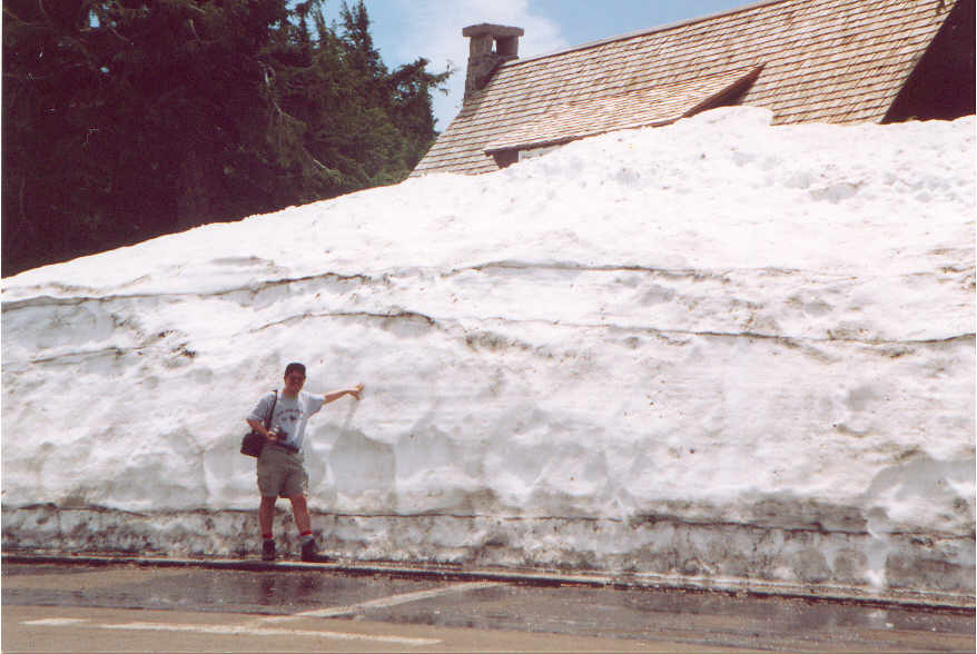
As we continued up the hill, the snow on the roadsides continued to thicken. By the time we reached the Visitor’s Center, it looked like we had entered a winter wonderland. My research on Crater Lake had told me that the park received an average of 533 inches (or almost 44 and a half feet) of snow a year. Still, it’s one thing to read that…it’s another to see a wall of snow taller than oneself. The snow was standing six feet high in most places. The snow that wasn’t piled up was running in streams around our feet. We slogged our way through the parking lot and went into the Visitor’s Center. The center was small, but had that distinctive “Park Service” feel to it (visitors to multiple National Park Visitor’s Centers will know what I’m talking about). We obtained a couple of maps, and then went to the help desk to ask about hiking possibilities up Garfield Peak. The ranger at the desk said that Garfield Peak was still snowed in, and that we couldn’t make it up the mountain unless we had snowshoes. Since we didn’t have snowshoes, our hiking options sounded limited.
We left the Visitor’s Center and continued up the mountain. I thought we’d never get to the lake. But, after only a five minute drive, we arrived. We were stunned by the sight. Below us sat a large, pristine, alpine lake. The crater’s slopes were draped with snow, thereby giving it the appearance of being a large ski jump. Completing the ambience was the absolute silence that permeated the area. All we could do was stand awestruck at the view.
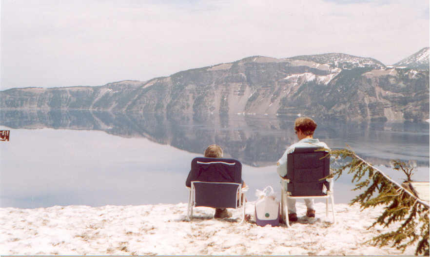
We walked toward the snowdrifts on the rim to get a better look. Getting closer to the rim only enhanced the details that we had seen on our arrival. We got our first view of Wizard Island, as well as the sights along the crater’s west rim. But, what really impressed us was how deep the snow really was. When we approached the rim, we noticed that a few signs that warned people not to proceed further on the rim, otherwise they might fall down the crater. We wondered why there weren’t any fences around to further protect otherwise careless visitors. Then, we noticed that we were standing on top of the fences. The snow was deep enough that it had covered all but the very tops of the fence posts.
We were further reminded of the depth of the snow as we made our way to the Crater Lake Lodge and the trailhead to Garfield Peak. The 10 foot snowdrifts we passed along the way were indications of what we’d find at the lodge. When we made it to the lodge’s parking lot, we looked up to Garfield Peak. We then realized what the ranger meant when she said the trail was snowed in. The field from the lodge to the base of the mountain was completely covered in snow. While we could make out part of the Garfield Peak trail along the side of the mountain, it eventually disappeared into another snowbank.
With our hiking plans thoroughly dashed, we decided to find an alternate trail. We ventured into a smaller visitor’s center that sat near the lodge on the caldera’s rim. We asked the ranger in this center if there were any trails open in the park. She said there weren’t, but that we could hike on the rim road around the lake. She said that the road had been open to vehicle traffic up to the rim road’s junction with Highway 138 (otherwise known as the North Junction). However, the snow plows had proceeded further east of that point. Individual hikers were able to hike along the road up to the point where the snow plows were still working.
After thanking her for the information, we set out for the North Junction parking lot. We parked at a couple of lookouts along the way, just to get pictures of different views of the lake. It was amazing how the lake’s appearance changed depending on where one stood on the rim. But, the elements of snow, water, and silence never changed regardless of the location.
Eventually, we made it to the North Junction parking lot. We put on our backpacks, and set off along the road. As we quickly discovered, the downside to this hike was that we would be unable to see the lake. The stretch of road that we were hiking along went behind Llao Rock, which blocked our view of the lake. But, we saw other sights that were almost as impressive as the lake itself. For example, vast fields of snow and pumice lay to the north of the road. Far in the distance, we could make out some of the other peaks in the Cascade Range. All around us was wonderful alpine forest. Also around us was the ever present snow, which stood at twelve foot high attention all around us. The sunlight shone through the snow drifts, giving the drifts’ nooks and crevices a dark blue tint. It looked slightly ominous, as though the frozen water was saying that it would be drowning us if it could only move. Fortunately for us, it couldn’t. But, we could respect its power by enveloping ourselves in the silence that permeated the area.
The road was an easy trail to hike. It had a moderate slope for about a mile, and then turned into a down slope for another mile. While the sun was beating down throughout the entire trip, it was easy to remain cool. Whenever we felt a little heated, we would just scoop up some snow and put it in our caps. The combination of the melting ice in our hats and the cool breeze that whipped up off the snow produced conditions that were perfect for hiking.
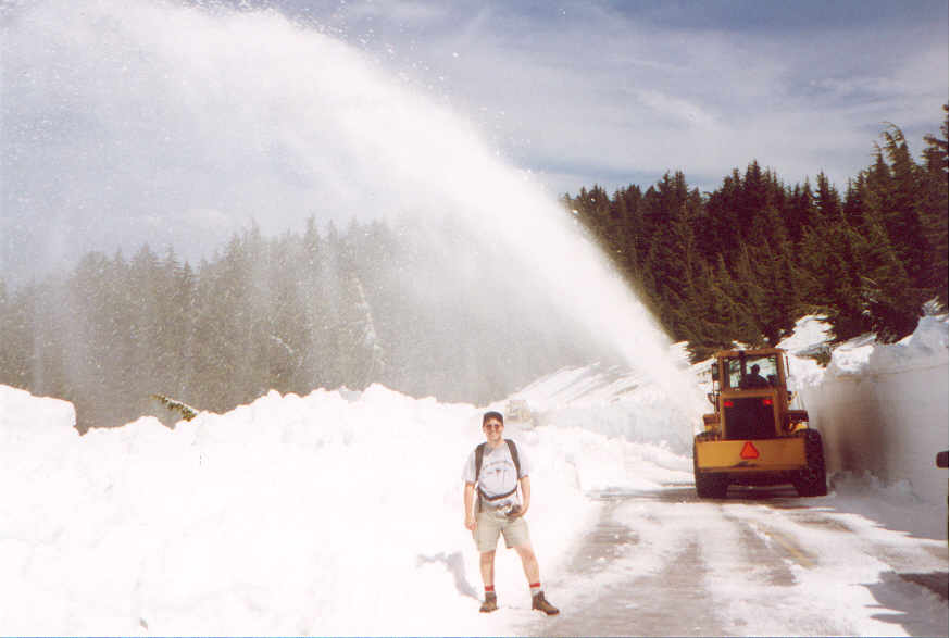
About a mile into the hike, we became aware of a rumble in the distance. The rumble became louder as we continued along the road. Soon, we began noticing snow in the trees, as though it had recently snowed on them. It didn’t take us long to find the source of this snow. We came across the Park Service crews clearing the Rim Road with bulldozers and snowplows. The bulldozers were used to scoop the first six feet of snow off the pile covering the road. Then, the snowplow removed the last four to six feet in an impressive arch that blanketed the trees with a white coat. We were a little reluctant to get too close to the plowing. But, one of the crew members waved us forward to get a better look. After walking over to him and introducing ourselves, he proceeded to explain the mechanics of snow removal at Crater Lake. He said that they would plow a mile on a good day. Most days, they were able to plow only between a quarter-mile and a half-mile. That was why they didn’t finish plowing snow until early July. I asked him how they were able to figure out where the road was. He pointed to some painted sticks on either side of the road. These sticks stuck out about a foot above the top of the snow drifts and were spaced about ten feet apart. He said that these sticks, which were actually about 15 feet tall, marked the sides of the road. All the crews had to do was put the equipment in between the sticks and they could plow the road. It was an ingenious, low tech solution to the problem of finding the road.
After taking some pictures of the snow removal, we hiked back to our car. Upon reaching our car, we drove back to the lookout at the Watchman (another of the peaks lining the caldera). We drank in the majestic beauty and tranquility of the scene one more time. It seemed amazing that something that was birthed in such destruction could turn out so breathtakingly beautiful. The fact that it did turn out this way was a reminder of the wonderful healing power in nature.
The people who decided that Crater Lake should be a national park were farsighted geniuses. This natural gem deserved to be preserved for all to enjoy. Now that it has, everyone should take the opportunity to see it if they are visiting southern Oregon.
2004 Update –
Once we realized that we were going back to Oregon, a return trip to Crater Lake was a certainty. The lake’s majesty was so impressive to us in 2003, that we had to go back to experience it again. While that majesty was still there, I have to say that it wasn’t as beautiful as we remembered it. Why not? Because the snow was almost entirely gone. The snow covered caldera walls were such a stunning contrast to the lake’s brilliant blue waters that the scene seemed empty without the snow. That doesn’t mean we didn’t enjoy our return trip to Crater Lake. It just means that it was prettier in June than it was in July.
We pulled up to the lake around 11 a.m. The first thing we noticed (other than the lack of snow) was that there were a lot more cars in the parking lot than there were the last time we were there. It seemed like most of southern Oregon had decided to have a day at the lake in order to avoid the heat that permeated the area. We fought our way through the crowds in the gift shop in order to find the spot to purchase tickets for the boat tour on the lake’s surface. We got close enough to the checkout counter to hear that these tickets were not sold at the main gift shop, but were instead sold at a temporary facility in the Cleetwood Cove parking lot. So, we filled up our water bottles with ice in the restaurant next door, and drove off to Cleetwood Cove.
We pulled into the parking lot after a 15 minute drive and walked up to the temporary building. The schedule at the building said that the only tickets available were for the last boat of the day, which left at 4 p.m. However, when we asked for two tickets on the 4 p.m. boat, the ranger told us that they couldn’t sell any tickets until they had a count of how many people were on Wizard Island from the morning tours. Since the 4 p.m. boat was the last trip of the day, it represented the last opportunity for those on Wizard Island to depart or else be stranded overnight. Thus, it was important to take those folks into account before selling tickets to other people. The ranger told us it would be about 30 minutes before they had a final count. So, we sat down next to the building and waited. While waiting, we discussed the various possible hikes that we could take before the boat tour. We originally thought about climbing to the top of Garfield Peak. But, considering that was listed as a three hour hike, we realized we wouldn’t have enough time to drive to Garfield Peak, complete the hike, and make it back to Cleetwood Cove in time for the boat. So, we decided to try to reach the Watchman, which was listed as a one hour hike.
After 30 minutes, the squawking on the radio told everyone that there were so many people on Wizard Island, that the tour company would be sending a special boat to pick those folks up. Thus, all seats on the 4 p.m. boat were open for sale. We bought our two tickets($22.50/ticket) and got back in the car. After another quick stop at the restaurant for some ice, we set out for the Watchman trail.
We got to the Watchman trail only to find it closed. As I’d mentioned before, most of Crater Lake’s snow had melted. However, there were a few snow patches still around, particularly on the north facing slopes of any cliff. The bottom half of the trail up the Watchman was one of those that was still filled with snow. Consequently, it was the only trail in the park that was still closed. While we were disappointed, we decided to look for an alternative trail. It turned out that there is a trail that follows the caldera’s rim which eventually hooked up with the Watchman trail. However, the map indicated that they merged above the current snow pack. We decided to hike this rim trail and see if it allowed us to bypass the snow and reach the top of the Watchman.
It turned out to be a great choice for hiking. We parked at the Lightning Springs parking lot and proceeded north on the trail. Before long, we were walking through stunning forest. Occasional vistas of the caldera’s sheer cliffs and the lake’s incredible blue waters peered from just beyond the trees. It was an exceptionally scenic hike. We continued around the Watchman and approached the Watchman trail. As we got near the point where the trails merged, we started walking through mud created from the snow runoff. I was hopeful that this mud would be all we’d find. But, we eventually found ourselves on a snow bank. Any hope I had of being able to make the Watchman trail vanished when I saw a sign that prohibited any further hiking on the trail. It was frustrating, because I could see the snow free portion of Watchman trail about 100 feet from where we were standing. But, we decided to respect the signs and head back to our car.
The hike we had taken took about an hour. That gave us just enough time to drive back to Cleetwood Cove and hike down the trail to the boats. The hike was 1.1 miles long. But, because it was all downhill, it didn’t feel like a problem. We were at the boats in 15 minutes. After a brief safety course, we set off for our lake tour. I have to admit that things look quite different from “lake level” than they do from the caldera’s rim. For example, Llao Rock has much more detail to it than the monolithic block that one sees from the Visitor’s Center. But, one thing didn’t change that I expected would. I thought the lake’s deep blue color was the result of the light reflecting in a way that accentuated the blue when observed from the rim. I thought the water would have a different color if I were at the lake’s surface. I was totally wrong. The water is just as blue when seen from the surface as it is from the rim. No wonder people think there is blue dye in the water.
The tour was informative, but a bit too long. While there are several interesting things to see along the caldera’s walls and inside the lake, it seemed like we could see them a bit faster than the two hours we took on this tour. It probably wouldn’t have been as monotonous had we had a ranger who did a better job describing what we were seeing. Still, I’m glad we went on the boat tour, and would recommend it to anyone who is in shape (more later) and who wants a different perspective on the lake.
After the tour ended, we hiked back up the Cleetwood Cove trail to our car. I knew I would need to make the 1.1 mile trek uphill. But, I had forgotten what it felt like to climb 700 feet in 1.1 miles. Given the distance, the climb, and the elevation that we were at (about 7,000 feet), it took me about 35 minutes to finish the trail. We spent about 25 minutes resting after that hike. While I was able to make it, I think that anyone with any sort of physical aliment (disability, heart condition, etc.) should not make this hike.
It was almost 7 p.m. when we left Cleetwood Cove’s parking lot to depart from the park. We stopped at the Watchman trailhead one last time to get some pictures of the lake with caldera’s shadows filling the lake’s surface. Some thunderheads had formed just to the east of the lake, making for some dramatic scenery. It was just another reminder that Crater Lake is always changing and always presenting another face regardless of how many times a person visits it.
As I said before, I’d rather see Crater Lake with some more snow on the rim. But, we saw enough new things to make our return trip worthwhile. This second trip just confirmed that I’ll have to make time whenever I’m in southern Oregon to see this natural jewel. Only next time, I’ll make sure there’s a bit more snow on the ground before I go.
2003 Pictures (ML = Mike Lima picture. DL = Dianne Lima picture)
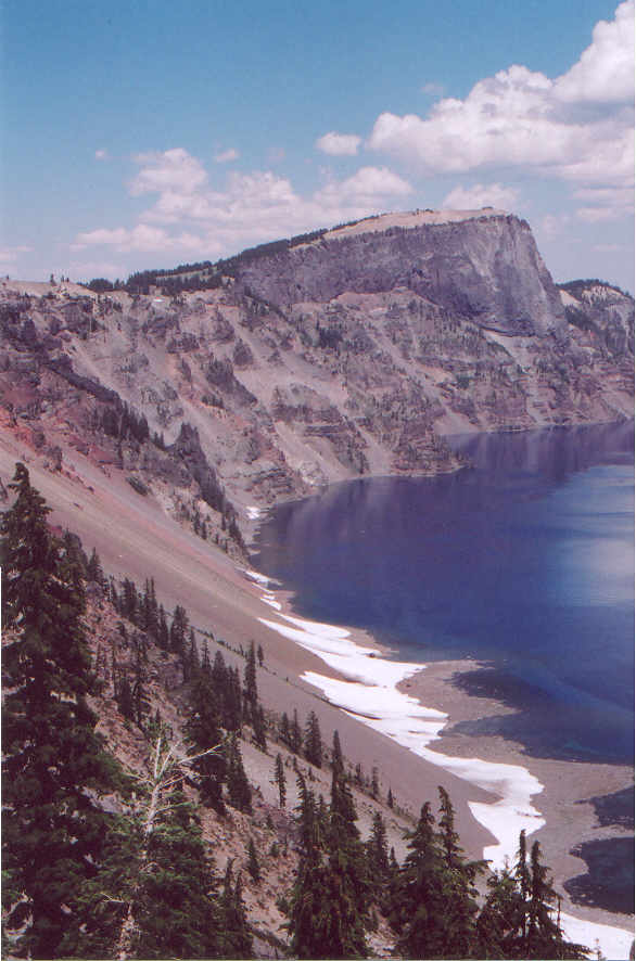
1) The southeast rim of Crater Lake (ML)
2) Llao Rock and the northeast rim of Crater Lake (DL)
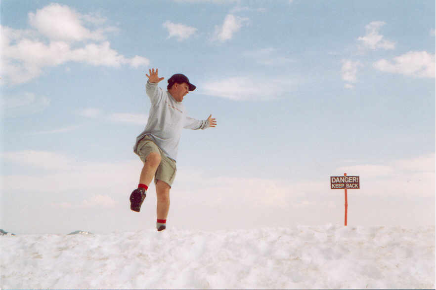
3) Just another day at the bea…er, uh…in the snow. (DL)
4) I shouldn’t have gotten that close to the edge. (DL)
5) Hiking is easy when the road is clear. (DL)
6) Nothing like a snow shower to cool one off after a long hike (DL)
7) I’m 5’ 11”. That will give you some idea of how high the snow pile was. (DL)


2004 Pictures (ML = Mike Lima picture. DL = Dianne Lima picture)
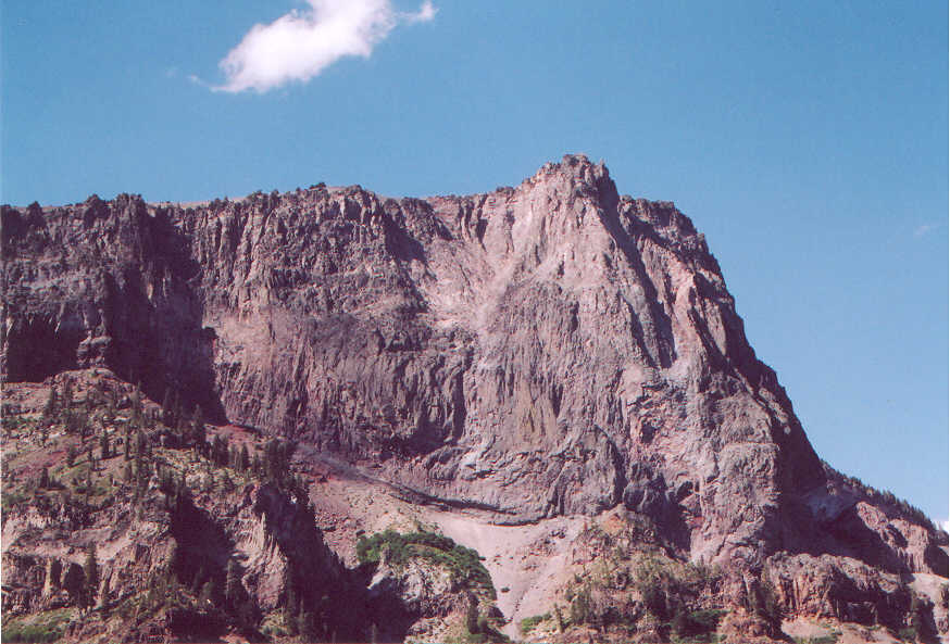
1) Llao Rock (ML)
2) Taken from Crater Lake’s west cliffs (ML)
3) Some colorful rock formations on Wizard Island (ML)
4) Crater Lake at dusk (ML)
5) Llao Rock taken from the lake’s surface (ML)
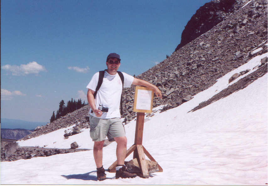
6) Me at the sign saying “No further hiking on the Watchman trail due to snow.” (DL)
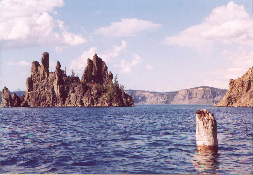
7) The Phantom Ship and the Old Man of the Lake (DL)
8) Pumice Castle (ML)


Home
This page hosted by