


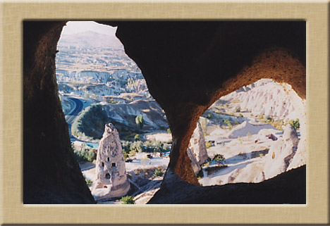
CAPPADOCIA When the art director of the sci-fi classic “The Planet of The Apes”, needed stimulus for the village that the simeon population lived in, he found his inspiration for their living quarters, to be constructed in Hollywood, in photos of The Valley of the Fairy Chimneys taken in Cappadocia, Turkey. The
 concept and designs used in the films where based on these amazing structures. The unearthly architecture of trogolite cities are carved into the mountainsides producing a habitat that is unique to this region of the world.
( This link
takes you straight to the page of Turkish Ministry of Culture where you find video clip downloads including a Cappadocia mini video clip , that will really be a treat. Do not miss it! ( once u get there, right click any link , and then choose the 'save as' option . ) When motion picture photography was needed to show the bizarre landscape and
living areas of alien civilizations of another planet for “Star Wars”, George Lucas picked this location for the on location scenic photography, and in both movies the results were successful beyond belief. This is the feeling that the photographer sees and experiences through the viewfinder of his camera. It is a truly a wonderland of landscape and people made for nature photography and photojournalism
concept and designs used in the films where based on these amazing structures. The unearthly architecture of trogolite cities are carved into the mountainsides producing a habitat that is unique to this region of the world.
( This link
takes you straight to the page of Turkish Ministry of Culture where you find video clip downloads including a Cappadocia mini video clip , that will really be a treat. Do not miss it! ( once u get there, right click any link , and then choose the 'save as' option . ) When motion picture photography was needed to show the bizarre landscape and
living areas of alien civilizations of another planet for “Star Wars”, George Lucas picked this location for the on location scenic photography, and in both movies the results were successful beyond belief. This is the feeling that the photographer sees and experiences through the viewfinder of his camera. It is a truly a wonderland of landscape and people made for nature photography and photojournalism
 Cappadocian region is the place where nature and history
come together most beautifully within the world. While geographic events are
forming Peribacalarý (fairy chimneys), during the historical period, humans
had carried the signs of thousand years old civilizations with carving houses
and churches within these earth pillars and decorating them with frescos.
Cappadocian region is the place where nature and history
come together most beautifully within the world. While geographic events are
forming Peribacalarý (fairy chimneys), during the historical period, humans
had carried the signs of thousand years old civilizations with carving houses
and churches within these earth pillars and decorating them with frescos. During the Roman Emperor, Augustus period, territories of
Cappadocian Region as a wide region lying till to the Toros Mountains at
south, Aksaray at west, Malatya at east and Eastern Black Sea shores at north
within the 17 volume book named 'Geographika' of Strabon, one of the Antic
Period writers.
 Today's Cappadocian Region is the area covered by Nevţehir,
Aksaray, Niđde, Kayseri, and Kýrţehir cities. More limited area, rocky
Cappadocian Region is composed of Üçhisar, Göreme, Avanos, Ürgüp, Derinkuyu,
Kaymaklý, Ihlara and environment.
Today's Cappadocian Region is the area covered by Nevţehir,
Aksaray, Niđde, Kayseri, and Kýrţehir cities. More limited area, rocky
Cappadocian Region is composed of Üçhisar, Göreme, Avanos, Ürgüp, Derinkuyu,
Kaymaklý, Ihlara and environment.
Traditional Cappadocian houses and dovecotes carved into
stones are showing the uniqueness of the region. These houses are constructed
on the feet of the mountain via rocks or cut stones. Rock, which is the only
construction material of the region, as it is very soft after quarry due to
the structure of the region, can be easily processed but after contact with
air it hardens and turns into a very strong construction material. Due to
being plentiful and easy to process of the used material, regional unique
masonry is developed and turned into an architectural tradition. Materials of
neither courtyard nor house doors is wood. Upper parts of the doors built
with arches are decorated with stylized ivy or rosette motifs.
Dovecotes within the region are small structures constructed within 18th century and end of 19th century. Some of the dovecotes, which are important for showing Islamic picture art are constructed as monastery or church. Surfaces of dovecotes are decorated with rich inscriptions and adornments by regional artists.
 VOLCANIC ERUPTIONS AND GEOLOGICAL FORMATION
Mount Erciyes, Hasandagi and Golludag were active volcanoes in the geological periods. Alongside with many other volcanoes, eruptions of these volcanoes started in the Early Miocene (10 million years ago) and have continued until the present day.
The lava produced by these volcanoes, under the Neogene lakes, formed a layer of tufa on the plateaus, which varied in hardness and was between 100 and 150m thick. Other substances in the layer are ignimbrite, soft tufa, tufa, lahar, ash, clay, sandstone, marn, basalt and other agglomerates.
Plateaus, having been essentially shaped with the lava from the bigger volcanoes, were continuously altered with the eruptions of smaller volcanoes. Starting in the Early Pliocene Period, the rivers in the area, especially Kizilirmak (the Red River), and local lakes contributed to the erosion of this layer of tufa stone, eventually giving the area its present day shape.
Fascinating Curves
Another characteristic feature of the area is the sweeping curves on the sides of the valleys, formed by rainwater. The array of colors seen on some of the valleys is due to the difference in heat of the lava layers. Such patterns can be seen in Uchisar, Cavusin/ Güllüdere, Goreme/ Meskendir, Ortahisar/Kizilçukur and Pancarlik valleys.
VOLCANIC ERUPTIONS AND GEOLOGICAL FORMATION
Mount Erciyes, Hasandagi and Golludag were active volcanoes in the geological periods. Alongside with many other volcanoes, eruptions of these volcanoes started in the Early Miocene (10 million years ago) and have continued until the present day.
The lava produced by these volcanoes, under the Neogene lakes, formed a layer of tufa on the plateaus, which varied in hardness and was between 100 and 150m thick. Other substances in the layer are ignimbrite, soft tufa, tufa, lahar, ash, clay, sandstone, marn, basalt and other agglomerates.
Plateaus, having been essentially shaped with the lava from the bigger volcanoes, were continuously altered with the eruptions of smaller volcanoes. Starting in the Early Pliocene Period, the rivers in the area, especially Kizilirmak (the Red River), and local lakes contributed to the erosion of this layer of tufa stone, eventually giving the area its present day shape.
Fascinating Curves
Another characteristic feature of the area is the sweeping curves on the sides of the valleys, formed by rainwater. The array of colors seen on some of the valleys is due to the difference in heat of the lava layers. Such patterns can be seen in Uchisar, Cavusin/ Güllüdere, Goreme/ Meskendir, Ortahisar/Kizilçukur and Pancarlik valleys. 
 back to my main page