

photo by Jonathan King

Photo by Jonathan King
As if to live up to its name, Beartown intoroduced us to one of its citizens.
Playing: Hard Times.
photo by Jonathan King
Photo by Jonathan King
As if to live up to its name, Beartown intoroduced us to one of its citizens.
.....Many years ago, sometime about 1970-1971, I read in the Wonderful West Virginia Magazine that West Virginia had purchased a small parcel of land know to the locals as Beartown. At that time, I was living in Dunbar and was working for the US Postal Service. I decided that I wanted to visit this place called Beartown.
...............
.....After many years, on Columbus Day, I revisitied the area with my wfe and Grandson Jonathan. You must walk the boardwalks now, but it is still a humbling experience. From the parking lot, a path leads to the boardwalk. Looking ahead, you have the feeling that you are going right into the bear's den.
...............Photo by Jonathan King
.....
.....After a short distance, you have the choice of taking the high road or taking the low route. We chose the low one.
.....My wife's family lived at Caldwell, in Greenbrier County, so,during our next visit, I loaded up my family in our 1969 Opal station wagoon and drove the thrity milies or so up Route 219 from Lewisburg in search of Beartown.
.....At the top of the south end of Droop Mountian, we found a small sign that said "Beartown". We turned off the highway to the right on a rural road. After driving through some open country for about a mile and one-half, we came to a small wooden sign that said Beartown. We found ourselves on a dirt track of a road that lead us through the woods to another sign that said Beartown with an arrow pointing the way.
.....We parked the car and made our way along a woodland path and found an amazing jumble of rockformations. At that time there were now boardwalks, so we spent a wodnerful time crawing over, going around, and between facinating formations. I am glad that we got to experience this early verson of Beartown State Park. When we got bak home to Dunbar, I wrote a letter the the West Virginia Magazine discribing our adventures and describing Beartown. To my delight, my letter was published in the magizine.
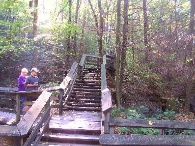
.....Photo by Okey L. King.

.....Carolyn take a rest on some nice benches halfway up this flight of steps. The formations above are fantastic.
.....
.....Photo by Jonathan King
........................Photo by Jonathan King
......
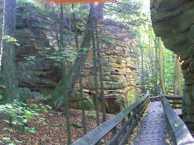
......Photo by Jonathan King
.....This is one of the strange rock combinations along the way.
..............
.............Photo by Jonathan King
.........
.........Photo by Jonathan King
.....According to the information sign concerning these holes in the rocks, no one knows for sure what causes the holes.
......................
......................photo by Okey L. King
.....This is one of my favorite formations
.....
.....Photo by Jonathan King
.....After leaving Beartown, we visited Droop Mountain, the Cranberry Glades, drove the Scenic Highway, and stoppe at Witoga Sate Park. Pages on these places will follow the Beartown Page so keep tuned.
.....Note: Someone suggested that I insert maps to show folks just exactly where the places on my pages are. I thought about it. But, I decided that inserting maps that were not of my work would be intrusive. I have decided to rely on verbal maps that will draw pictures in your mind.
.....Beartown is about thirty winding miles north of Lewisburg over Route 219 and is just over the line in Pocohontas County. Yo tun right at the old Mt. Olivet Church. Droop Mountian Battlefield is just about three miles further north across the flat top of Droop Mountain. The Battlefield is on the norhern edge of the mountain.