
http://www.msss.com/mars_images/moc/june2000/gorgonum/gorgonum2_c100.jpg
Analysis of Mars Global Surveyor MOC Image m1501228d
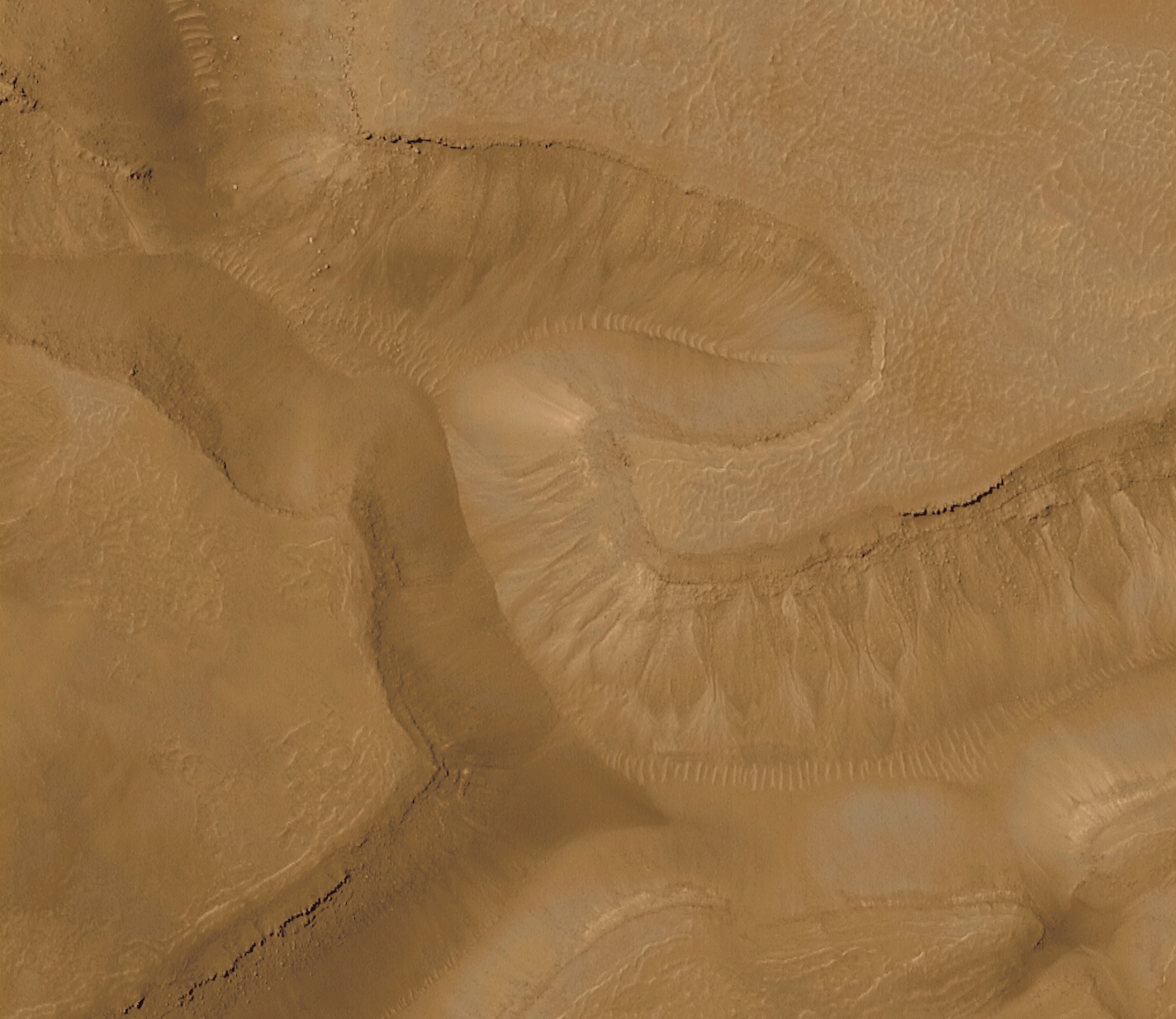
Photographic evidence supporting the 3 Dimensional nature of the "Martian tube" anomalies
As Mars anomaly researchers continue their analyses of images obtained by the Mars Global Surveyor a number of recurring oddities continue to spark debate amongst their ranks. Numerous images reveal vast networks of interconnected conduit with load bearing members or "ribs" for structural support. These appear to be buried deeply enough in the Martian regolith that only the topmost portions of the ribs protrude above surface of the surrounding terrain.
The official explanation from the Jet Propulsion Laboratory labels these features as Ā"Dune Trains", a series of repeating ripples in the sand caused by the random actions of Martian zephyrs and local topographic features.
First let's take a look at an actual Martian Dune train image from the Malin Space Science Systems image repository.
A link to the original image is provided
below.
http://www.msss.com/mars_images/moc/june2000/gorgonum/gorgonum2_c100.jpg
Comparing this image to MOC Image m0400291a leads this author to the inescapable conclusion that the features known as the "Martian tubes" are an all together different phenomenon than a simple dune train. These features clearly descend into the ground rather rapidly. Also, if these were "dune trains" as postulated by JPL would not the dune material have the same color and albedo from trough to crest as in the image cited above? Clearly, the ribs of this edifice are of a different material than the rest of structure. Why this is not obvious to the researchers at NASA and JPL is beyond this author's comprehension.
Speculation as to the nature of this image has been rampant on the internet, covering a wide range of topics some so fantastic that many Mars anomaly researchers have now stated that they believe these formations to be purely natural simply because they assume that to be associated with such fringe elements of the genre will impugn their highly vaunted credibility.
Such close mindedness may well deny them the opportunity to make real discoveries on the nature of our sister planet.
As researchers peruse the massive image archives from the Mars Global Surveyor numerous other tube like formations have been located on the surface of our sister planet. Most however, do not have the clarity and resolution of MOC Image m0400291a. Also, the majority of these edifices appear to have been covered over with eons of martian dust and debris leaving only the "ribs" visible and obscuring the translucent nature of tube walls.
That is, until MOC Image m1501228d came along. A second high resolution image of amazing clarity which undeniably illustrates the tube like nature of these anomalies. Being a very large image (replete with one of those annoying data drop outs that seem to mysteriously plague the most controversial Mars images) we will be breaking this image into an upper and lower portion for our analysis.
Click on the image crop to go to the annotated image analysis
(These images are quite large!)
Upper portion
Lower portion
Clearly, this image illustrates a plethora of anomalous features. The ribs running around the circumference of this artifact exhibit an obvious three dimensional aspect as one would expect from a load bearing member. The darkened wall of the defile into which the tube descends helps to accentuate their height and breadth against it's shadowed walls.
The lower portion of the image is startling in it's clarity as we can see this structure descend beneath the surface of Mars and then re-emerge from below the ground some distance away. Sand dunes, to this author's knowledge, do not descend underground and re-emerge in another location. Sorry folks, this is not a sand dune.
There are also a number of unusual craters adjacent to this structure (indeed, unusual craters abound in all the areas where these tube like formations are found). In this image we find another hexagonal crater and a number of craters that have unusual bottoms. One , in particular looks almost as if it could have liquid water at it's bottom. Around the crater rims, we see a highly reflective
substance. A likely hypothesis is that this shiny area consists of water ice on the rim of this crater.
Quoting the Discover Science news recent interview with geophysicist Maria Zuber of MIT,
"because the northern cap lies at a
lower elevation than the rest of the planet, "water than you put down almost
anywhere in the northern hemisphere is going to flow toward the pole. It is quite
probable, then, that you once had standing bodies of water at high northern
latitudes. They might not have persisted for very long, because we don't know
how warm it was and things may have frozen over quickly. But you clearly
could get the water up close to the pole."
Clearly, Mars was not always the frozen wasteland it is today. What happened?
Some of the ancient water could have been lost to the atmosphere and then,
over countless millennia, ejected into space through complicated interactions
with the Martian magnetic field. Some might still be locked in aquifers and other
formations beneath the surface. And some may exist in the southern polar
cap--but not much. The southern cap is significantly smaller than the northern
one. Even if the Mars Global Surveyor finds water ice in the south, it won't
come close to eliminating the water shortage, according to Zuber.
"We haven't either improved or diminished the possibility of life on Mars," she
says. "Essentially, what we have done is exacerbate the problem of there being
too little water on Mars today compared to where there was earlier. Now those
people who have proposed oceans have a bigger task in explaining where the
water went."
Zuber postulates that Martian water might "still be locked in aquifers and other
formations beneath the surface". An interesting hypothesis. Perhaps there could even be a body of liquid water under Mar's northern ice cap (a notoriously under-imaged area of the planet), similar to Antarctica's Lake Vostok. A biosphere capable of harboring life.
Such an hypothesis makes images like fha01602b
all the more interesting to ponder over. Here we see another "dune train" type of formation. Could this be another of these tubular anomalies, a construct of intelligent design, obscured from sight by the shifting sands of Mars?
Crater Lake
The highly reflective nature of the crater floor is akin to a standing pool of water, it's surface broken into ripples by a waterfall cascading over the crater's lip. In a negative of this image shown below, the "waterfall" is clearly apparent as cascades into the crater lake.
Author's note:
Photon

Crop of MOC Image m1501228d
Special thanks to Al Reaud for image annotations
(C) 2001 Danger Zone! Productions

Crop of MOC Image m1501228d
Special thanks to Al Reaud for image annotations
(C) 2001 Danger Zone! Productions


http://ida.wr.usgs.gov/fullres/divided/fha016/fha01602b.jpg

Special thanks to Sue Bradford for this image
Photographic analysis does not allow one to leave "no stone unturned". It is, however, all that is available at the present time.
In 2003 and 2005 additional probes will be orbiting the red planet. Included in the instrument packages of these vessels is a camera capable of taking infra-red images and a ground penetrating radar unit. These instruments should yield definitive answers to questions like, "Are the tubes really tubes?",
"Are the pyramids of Cydonia hollow?", "Are there bodies of liquid water under the surface of mars?". Be patient. The answers will be forthcoming. Until then continue to question everything you see in regards to Mars.
And continue to speculate as you see fit. It makes certain folks very uncomfortable.


Constructive comments and/or suggestions? Send to Photon's feedback
Dissenting comments? Send At your own risk to
