 | ||||||
| Articles | Projects | Resume | Cartoons | Windsurfing | Paintings | Album |
Land Use at Island View Beach, B.C.

Waterose et. al.
Index:
Section 1. Introduction:
Effective coastal zone management requires basic inventories of land areas, including geomorphology, ecology, and economic uses to implement sound policy decisions. Island View Beach is a coastal marine park located approximately 15 kilometers north of Victoria on Vancouver Island, B.C.
Map 1. Island View Beach
Map Reference (Yorath, 1995)
The interactions between the diverse geological terrain, biota, and anthropocentric land use create a challenge for coastal zone management of this area. Some of the land use issues include: erosion control, preservation of the natural ecosystem, and, economic use of the land.
Section 2. Geomorphology:
2.1 Background:
The Island View Beach area has been strongly influenced by glacial deposition and erosion. Island View Beach is the result of over 100,000 years of geological events, and this a dynamic region shaped by high energy forces (Yorath, 1995). This area is isolated from the interior of the island by a low ridge that runs parallel to the coast and spans from Cowichan Head to Saanichton Bay. The ridge is part of the Quadra Formation, which resulted from outwash from the Fraser Glaciation, and is comprised of unconsolidated glacial deposits. The valley below the ridge is ideal for agriculture due to the rich organic soils. Other glacial features, such as James Island and Sidney Island, are truncated drumlins that consist of Vashon Till.
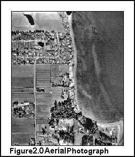 The cliffs above Island View Beach were formed by deposition during the Olympia inter-glacial deposition period. The major force of erosion that acts on the cliffs is wave action. The waves strike the base of the cliff, remove the unconsolidated material, and cause mass wasting. Longshore drift transports these eroded materials and deposits sand and gravel loads down current. The wave action entrains the smaller particles eroded from the cliff face, and through a combination of tides and constructive and destructive wave interference, carries the particles and deposits them in a sheltered area of the beach. The aerial view of Island View Beach is illustrated in Figure 2.0 to the right.
Some of the materials have been used in the creation of an artificial weir which functions as an erosion control feature and separates the fertile agricultural lands from the ocean beach. The wier is topped by a path for recreational users.
Too large to be removed by wave action, tree stumps and exposed roots serve as water level markers, remaining where they were deposited, approximately 1.5 meters below the high tide mark. These stumps have been dated as 2,040 years old and are evidence of sea level rise.
2.2 Terrain Analysis:
Two sections of the terrain are described. These include an incline cliff section and a shoreline section. The beach is primarily a soft substrate, with alternating bands of cobble and sand formed by wind and wave action. The cliffs rise above the shoreline to a towering 35 meters. The houses that are precariously perched atop the cliffs appear to be on the brink of tumbling off the cliffs.
2.2.1 Cliff Terrain:
The cliff terrain begins as a glentle slope topped by grasses and a thin layer of organic humus. The top overhangs the base in an incline caused by wind and wave erosion. The slope contains marine clay and a thin band of sandy loam. The silty clay absorbs water in the interstitial spaces which reduces internal cohesion of the soil particles. The unstable sections of these materials are moved downward by gravity to form slumps at the base of the cliff. The magnitude of soil slumps of unconsolidated materials vary from slight to major block slumps. Slumps deposit fine grain materials onto the beach.
The cliff slope steeply rises to a towering 35 meters above the beach. The
cross section of the cliff is illustrated in Figure 2.1 (Elliott, 1997). 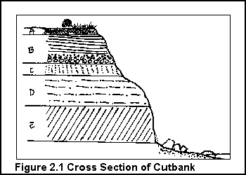 The uppermost layer, labelled A, is the soil horizon topped by the organic humic layer. This section also contains a layer of glacio-marine stone Victoria Clay which adds cohesion to the cut bank section of the cliff profile.
The next layer, labelled B, is several meters thick and contains well sorted sand and rounded cobbles depositied in a high energy fluvial environment. The stratified layers of sand and gravel represent fluctuations in flow velocity which are typical of near glacial environments. This section had a band of a resident algae species and there was also a red layer that indicates oxidation processes. A portion of the sands extruded outward from the cliff face. This indicated that they were more resistant than the surrounding materials, probably due to mineralization by groundwater. This section was banded by light and dark narrow striations, approximately 0.2 centimeters thick, that represented different types of seasonal hydrological conditions. The darkest bands represent low flow winter conditions, and the lighter bands represent high flow spring conditions. Portions of this consolidated material had fallen to the base of the cliff forming small platforms.
The next two layers, labelled C and D contain stratified sand and gravels deposited in fluvial environments at different times.
The next layer, labelled E, contains primarily fine marine clays. Some cobble is present in this layer, probably due to be ice-rafted material deposited by a retreating glacier. The top of the marine clay layer is masked by sand, gravel, soil, and, vegetation. The materials in the lower portion of this section were formed by a rise in sea level which occurred just prior to the Olympia Interglacial Period and are referred to as Dashwood Drift. This lower layer of the cliffs is estimated to be between 80,000-100,000 years old although no carbon-14 dating has been carried out. Some faunal remains are still evident, but the shells are beyond the range of carbon-14 dating. This indicates that at one time, there was a low energy slow moving shallow estuary that was rich in organics biodiversity.
Shot rock has been placed at the bottom of the cliff to mitigate erosion by wave action.
2.2.2 Shoreline Terrain:
The banded beach is subject to intense physical disturbances of rolling cobble. The alternating bands of cobble and sand are the result of a sorting regime caused by tidal and wave action. Coarser materials are deposited in high energy areas whereas finer materials are deposited in low energy areas. Fine organic material are deposited in the subtidal zone. The soft substrate of the beach forms gently undulating terraces as a result of wind and wave action.Approximately 50 meters offshore there is a rocky outcrop with a kelp forest. At the north section of the beach, a berm that is approximately 150 meters long, has been engineered to minimize erosion. It is constructed of pilings, concrete blocks, shot rock, and stumps. Even though it sits in the high tide zone, the agricultural field inland of the berm is vulnerable to flodding from the ocean through a culvert that tunnels beneath the berm.
Section 3. Biophysical:
3.1 Overview:
The berm divides the agricultural fields from beach. The biophysical features include multiple riparian zones, an intertidal zone, and, a variety of ecological communities.The dominant species in the riparian zone at the north end of the beach is speargrass. South of the berm, the dominant species include alder trees, shrubs, and, herbaceous flora. The upper splash zone substrate is dominated by large boulders. The high tide zone is strewn with naturally deposited driftwood logs and detached bull kelp. The intertidal zone is composed of sand, rounded cobble, and shells. This zone extends 100 metres from the high tide line and creates an intertidal soft substrate for shellfish habitation and other biota. There are bull kelp forests anchored to rock substrates 5 and 50 metres offshore. These marine forest provide diverse habitat for a variety of invertebrates.
3.2 Attributes of Riparian Vegetation Biophysical Unit:
The riparian zone includes alder trees, thimbleberries, speargrass, and horsetails. The lower beach riparian zone is dominated by grasses and shrubs that anchor the sandy substrate. The cliff riparian zone is dominated by trees; erosional forces have uprooted many of the trees. Shrubs and herbaceous species are the less dominant flora.
3.3 Attributes of Rocky Intertidal Biophysical Unit:
The intertidal zone consists of sand, rounded cobble, and shell fragments; a soft substrate provides habitation for shellfish and other biota. Plant debris on the lower beach area includes: red algae, laminaria and bull kelp. Bull kelp was visible in patches offshore and eel grass was observed in the beach seines. The beach seines yielded invertebrates including: red rock crab, crab appendages, jellyfish, ctenophores and barnacles. Sand fleas burrows dotted the sand substrate.
3.4 Avifauna and Other Transient Wildlife:
There was a great variety of avifauna that use this area. Loons were observed feeding between the intertidal zone and the bull kelp fields; seagulls were present in all of the biophysical zones.Section 4. Land Use:
4.1 Overview of Land Use:
Island View Beach has a wide variety of recreational land uses. These include: the parking lot, information board, boat launch, fishing, picnic area, and walking trails. This area is very popular for bird watching. Swimming is restricted due to strong currents.
4.2 Coastal Development:
Various erosion control devices are present, such as imported concrete blocks and large rocks that serve to dissipate wave energy. The constructed berm is used as a path and as an erosion control device. Agricultural lands, growing various legumes such as cabbage, were located on the sheltered side of the berm. Sport fisherman frequent the beach. Shell fish harvesting has been discontinued because of contamination. There was a dilapidated building by the posting, at the south end of the parking lot, that may have been a government facility or a residential dwelling. Other residential dwellings were located on the tops of the cliffs. Birds, plants, aquatic life, and other organisms occupy this area which is their natural habitat.
4.3 Values and Conflicts:
Conflicts of interest exist between public and private land uses of Island View Beach. Briefly, these conflicts include: multiple recreational consumer users; residential housing versus commercial tourism; natural environment versus enhanced environment; development versus parkland; and anthropogenic land use versus flora/fauna natural habitat use. The concerns of the private land owners are one of the more contentious issues.Private land owners are concerned about erosion of their property. It is currently unclear if the City is responsible to protect private land from future erosion or to provide landowners with financial compensation. The options are to construct erosion control barriers or to allow natural processes to occur that could result in the loss of private buildings. There are economic issues, assessment and valuation issues, and future land use issues.
4.4 Governance:
Governance issues include land zone categories, commercial fisheries, shellfish management, and park management. Future planning could involve rezoning that would alter land areas allocated for residential, commercial, agricultural, or park land use. Other changes may involve the recreational or commercial harvesting of fish and shellfish from the area.Ideally, a good coastal zone management plan can implement solutions for sustainable development that are both benign to the environment and enhance the quality of living for those that use this area.
Section 5. References:
Written for Royal Roads University ES307 Coastal Zone Management SeriesElliott, S. 1997. Original Graphic. Royal Roads University, B.C.
Yorath, C. J. and H. W. Nasmith. The Geology of Southern Vancouver Island. A Field Guide. 1995. Orea Book Publishers.
Waterose et. al.
Judith R. Burke
and: S. Ivanko, R. Luco, J. Walker, S. Wilmot
 email Waterose
Please Sign My Guestbook
Please View My Guestbook

| Articles | Projects | Resume | Cartoons | Windsurfing | Paintings | Album |
 | ||||||