![]()
![]()
|
Bay Area |
Hiking Page |
County Parks |
Feedback |
Location
![]()
|
Rainbows & Waterfalls 2000
|
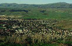 Santa
Teresa Park has gradually grown and changed over the years. More and
more
surrounding properties have been added to the park, until now it covers
1688 acres. It's a smaller sister to Almaden Quicksilver Park, running
parallel to it along the Santa Teresa Hills. It ranges in altitude from
200 feet at the Santa Teresa Golf Course to 1155 feet at the top of
Coyote
Peak, the highest point in the Santa Teresa Hills. The park has 14
miles
of trails. To the northeast is the Blossom Valley/Santa Teresa area of
San Jose, with its high-tech industries, strip mall shopping centers,
and
middle-class subdivisions. Beyond that to the east is low,
grass-covered
565-foot high Tulare Hill, Monterey Highway, Parkway Lakes, and Highway
101. Far to the east, forming the eastern wall of the Santa Clara
Valley,
is the high, dry ridge of the Diablo Range, topped by Mount Hamilton
and
the domes of Lick Observatory at over 4200 feet. To the southwest and
west
are Calero Reservoir, the wealthy Almaden Valley, the Los Capitancillos
Ridge of Almaden Quicksilver County Park, and the steep green Sierra
Azuls,
dominated by 3486-foot Mt. Umunhum. All of this can be seen from the
heights
of the park. Santa
Teresa Park has gradually grown and changed over the years. More and
more
surrounding properties have been added to the park, until now it covers
1688 acres. It's a smaller sister to Almaden Quicksilver Park, running
parallel to it along the Santa Teresa Hills. It ranges in altitude from
200 feet at the Santa Teresa Golf Course to 1155 feet at the top of
Coyote
Peak, the highest point in the Santa Teresa Hills. The park has 14
miles
of trails. To the northeast is the Blossom Valley/Santa Teresa area of
San Jose, with its high-tech industries, strip mall shopping centers,
and
middle-class subdivisions. Beyond that to the east is low,
grass-covered
565-foot high Tulare Hill, Monterey Highway, Parkway Lakes, and Highway
101. Far to the east, forming the eastern wall of the Santa Clara
Valley,
is the high, dry ridge of the Diablo Range, topped by Mount Hamilton
and
the domes of Lick Observatory at over 4200 feet. To the southwest and
west
are Calero Reservoir, the wealthy Almaden Valley, the Los Capitancillos
Ridge of Almaden Quicksilver County Park, and the steep green Sierra
Azuls,
dominated by 3486-foot Mt. Umunhum. All of this can be seen from the
heights
of the park.
The main park road, Bernal Road, climbs up the steep hills into the park and ends at the entrance to IBM's Almaden Research Center, one of the premier private research institutions in the world. Much of the land northwest of the park is IBM property, but a corridor through it has been granted as an easement, along the Stile Ranch Trail. Southeast of the park are hilly ranchlands, which are owned by IBM, leased to cattle ranchers, and provide a backdrop to the IBM Santa Teresa Programming Laboratory on Bailey Avenue. In 2000, a $4 parking fee (now $5) was imposed on parking in the upper parking lots at the Pueblo day use area. However, there are several free entrances to the park:
Created 9/17/99, updated 7/5/05 by Ronald Horii |