|
Breaking A Trail Through Bright Angel Canyon |
|
From the Grand Canyon Nature Notes, November 21, 1927 This autumn, in the month of November, to be precise - it will be just twenty five years since the first pack train made its way through Bright Angel Canyon. It was a rough and tumble journey the hazards of which may be difficult to imagine by those who now travel safely and comfortable across the Grand Canyon via the excellent Kaibab Trail. The perils that were faced by those hardy explorers who passed through the Grand Canyon in boats, and battled with the rapids of the Colorado River, are now known to many, but the adventure of the first party to cross from one side of the Grand Canyon to the other with a pack train have never been told. Here follows a brief statement of the circumstances. |
|
|
In the spring of 1902 it was my privilege to be assigned to the task of beginning the topographic mapping of the Grand Canyon for the U. S. Geological Survey. Naturally our party started work on the south side, the grand Canyon Railroad affording the most convenient route of approach. For several months the surveying operations - triangulation, leveling and plane table mapping - were carried on over the Coconino Plateau and from its rim down into the chasm. Then we began to seek a route across to the north side. But at that time there was no trail across from rim to rim, nor was there a bridge over the Colorado. |

| We found ourselves face to face with a barrier more formidable than the Rocky
Mountains - an abyss 280 miles long containing an unbridged, unfordable, dangerous river. Not unnaturally we cast longing glances up Bright Angel Canyon - it seemed to us such a convenient, straight avenue. But Bright Angel Canyon, we were told, afforded no practical route for pack animals, and might be impassible even to the foot of man. Lee's Ferry, at the head of Marble Gorge, of course, was suggested, but to cross the river there would require a detour of some 180 miles, mostly through parched deserts, where feed and water would have to be carried for the animals. There was but one other choice, to go west 35 miles and descend by the Bass Trail, cross the river in some way, and climb out on to the north side through Shinumo and Mauv Canyons. The crossing was known to be dangerous; the Bass Trail was merely a burro trail, still unfinished at the lower end, and the Shinumo Trail was little more than a faint track rarely used. Yet this was the route we finally selected. |
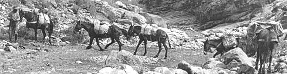
| About the middle of August, when the river had subsided to a moderate level, we set
out with a pack train of ten animals. W. W. Bass kindly consented to our using his home-made boat, and this, of
course, facilitated matters considerably. Unfortunately, however, we found that the boat was on the north side
of the river, and two of us, consequently, were obliged to match our strength against the current and swim across
to get it. The camp equipment was quickly ferried over, but the transferring of the horses and mules proved a difficult task. The animals, worn out by the heat, and unnerved by their descent over the great rock slide at the foot of the trail, could not be induced to enter the water. A stratagem had to be resorted to. they were led down to the rock platform, ostensibly so they might quench their thirst, then suddenly they were pushed over into the swirling flood. Quickly behind the boat they were then towed across, one by one, but in their frenzy many of them tried to swim back, or down stream, or even to climb into the boat, so that the rowers were more than once in danger of being dragged down over the turbulent rapids below the crossing. Eventually, however, all the animals were landed safely on the north side. |
| The next day we began the ascent to the rim of the Kaibab Plateau. it took us a day
and a half of arduous, exhausting work to gain the top, and the entire trip to Point
Sublime, where the mapping operations were resumed, consumed six days.
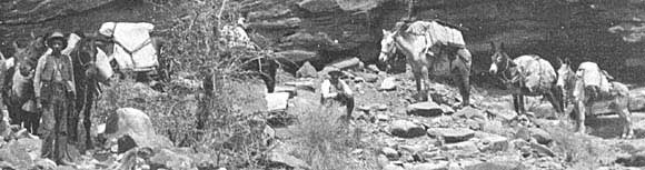
There was no thought, during the ten weeks while we were on the Kaibab plateau, of sending back to the south side of the canyon for supplies. the Bass crossing could not be negotiated by one man, nor even by two, and the whole party numbered only four. |
|

| Instead we sent to Kanab, Utah, although that place was 75 miles distant by trail
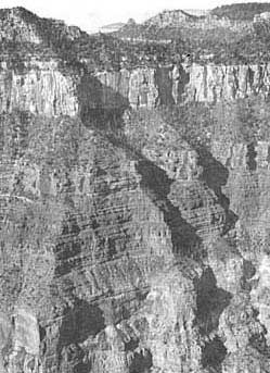
and the packer had to make a full week's journey to do his shopping there and return to the camp on the rim. As autumn set in, and the prospect of a snow storm grew more and more imminent (heavy snows begin to fall on the Kaibab Plateau usually early in November) we were forced to consider a retreat to the south side. the survey by that time had progressed as far east as the head of Bright Angel Canyon and we found ourselves directly opposite Grand Canyon Station, and only 13 miles distant from it in air line. Again Bright Angel Canyon beckoned to us as a possible avenue, and eagerly we scanned its sides for a practicable way down. Now Bright Angel Canyon is carved along a great fracture in the earth's crust, - a "fault", as it is termed by geologists, on which the strata are offset vertically by more than a hundred feet, and the lines of cliffs are consequently broken. The same fault extends southwestward into the embayment on the south side of the chasm and has made possible the building of the old Bright Angel Trail, now familiar to thousands of tourists. It did not take us long, therefore, to discover a route along this fault where the Red Wall, the Cliff of the Coconino sandstone, and the lesser cliffs are interrupted by slopes of debris. On the very day when we started to examine this route, by a remarkable coincidence, there emerged from the head of Bright Angel Canyon two haggard men and a weary burro. These men, Sidney Ferrall and Jim Murray, had explored up through the Canyon and finally had fought their way up along the fault zone. At once the prospects of the return of the survey party by this new route became brighter. However, it does not follow that where a small burro was boosted up, a pack train of heavily loaded horses and mules can come down in safety. Two of the party, therefore, set themselves the task of cutting out brush and rolling out logs and boulders, so as to make a reasonably clear way for the pack train. And this work they carried all the way down to the mouth of the canyon. |
|
|
On the 7th of November, when heavy clouds presaged a change in the weather, we hastily broke camp and proceeded down our new trail. So steep was it in certain places that the animals fairly slid down on their haunches. So narrow between the rocks was it at one point, that the larger packs could not pass through and had to be unloaded. Of accidents there were more than can be here be chronicled, but none of them, fortunately was of a serious nature. The mule carrying the most precious burden, the instruments and the newly made maps - was led with particular care, but she lived up to her reputation and made the trip without a stumble. |
| By noon the bottom of Bright Angel Canyon was reached, and then the party threaded
its way down along the bouldery creek, crossing and recrossing it to knee-depth, no less than 94 times. Camp was
made a short distance above the boxed-in lower part of the canyon, and a large bonfire was lit so that the people
on the south rim might see that we had successfully reached that point. (Ferrall and Murray had preceded us and
had made known our intention of returning via Bright Angel Canyon). that night it rained and the following morning
we beheld the rim of the Kaibab Plateau white with snow. Evidently we left none to soon. After a sojourn of several days in Bright Angel Canyon, during which the course of the stream was duly mapped, we proceeded to the river and once more faced the problem of crossing it. With the aid of a boat lent by a friendly prospector, however, this was accomplished with little difficulty, the animals, now homeward bound, having apparently lost their fear of the river. Soon, therefore, we were scrambling up the prospector's steep burro trail and without serious mishap reached our goal on the South Rim. The next year, when the survey was extended eastward, Bright Angel Canyon became our regular route of travel across the Grand Canyon, both northward and southward, although the trail remained as rough as ever. A steel row boat, in two sections, was packed on mules to the river crossing, to replace the wooden boat which had been swept away by the flood. Some years later enterprising citizens of Kanab, in order to promote tourist travel to the north rim, improved the trail up Bright Angel Canyon, and spanned the river with a steel cable along which a traveling carriage large enough to hold a pack animal could be hauled across. When the National Park Service took over the Grand Canyon, in 1919, finally, it set to work in earnest to make Bright Angel Canyon the main avenue for travel across the chasm. It built a good modern trail - The Kaibab Trail, as it is called, from Bright Angel Point to Yaki Point and replaced the steel cable by a fine suspension bridge. Needless to say, it has afforded the writer no little satisfaction in 1925 again and again in 1927 to travel over this new and to him almost luxurious route. |
Return to Photographic Exploration
|
A TRIP DOWN THE HERMIT TRAIL |
This page hosted by