|
|
|
 |
East
Caradon Mine
View
from the main road
|

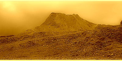
| East Caradon
Mine seen from the Upton cross road with the summit of Caradon Hill summit
behind. A prominent burrow lies in front of the dressing floor location (2), but
the
tip is decreasing in size every year through material removal. Nothing remains today of William's Shaft Engine house but its location can be identified by the waste dump beside the L&C railway siding (1). Behind this the count house is still standing amidst a stand of trees and is open as the Wheal Tor Hotel. North Shaft (3) lies nearer the hills summit linked with Williams Shaft underground and the adit mouth lies in the intervening gully. Symons' map places the count house higher up the hill than Wheal Tor indicating that the current building was built after 1863, perhaps as a grander structure than the original.
|