Mt. Sparrowhawk - Spray Lakes Road
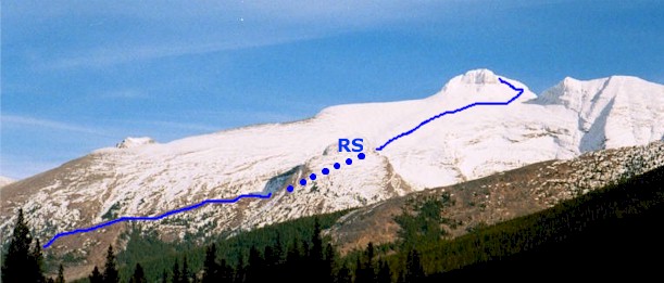
RS - Big Rock Spur

Mt. Sparrowhawk
Scramble: Class 1 – Steep Hiking
Altitude: 3,121m (10,237 ft)
Elevation Gain: 1,350m (4,428 ft)
Ascent Time: 3 1/2 – 5 Hours
Best Season to Scramble: Mid-June to September
Highlights
This scramble offers a sense of remoteness and impressive
summit views, which make the first hour + of bushwhacking worth while. It should be
attempted when the front part of the summit block is relatively free of snow. If there is
a patch of snow in front of the summit block but only extends a quarter of the way down
the big slope to the rock spur you should be okay. This ensures that the final meters
around the back of the summit block are clear. You can actually check the last few meters
of the summit block from Ribbon Creek on Highway 40. Stop on the side of the road just
past the turnoff into the Ribbon Creek/ Nakiska ski area. The summit block is up the North
Fork of Ribbon Creek on the right hand side. Binoculars would help.
Getting There
If you are scrambling from mid July to August you probably will
not need to check the summit block and can go through Canmore, which is shorter. From
either Banff 26km (16.2miles) or Calgary 106 km (66.2 miles) drive to Canmore and from the
Bow River bridge in Canmore to the Mt Sparrowhawk parking lot drive 26.3 km (16.4 miles).
The road from the Bow River bridge takes you past the Canmore Nordic Centre and onto the
Spray Lakes road (packed gravel).
If you want to check the summit block, head west out of Calgary on the
TransCanada highway # 1 for 79km (49.4 miles) and take the Kananaskis Country highway # 40
turnoff and head south. The Ribbon Creek turnoff to check the summit block is 23.4 km
(14.6 miles) south. Continue south and turn right into Peter Lougheed Provincial Park
which is 49km (30.6 miles) south of the TransCanada. From this turnoff drive 2 km (1.25
miles) and turn right on Spray Lakes road driving a further 37.7km (23.6 miles) north
until you reach the Mt Sparrowhawk parking lot on your left.
If your base is Banff head east on the TransCanada for 52km (32.5
miles) to highway 40 and follow as above.
Route Description
From the photo above you can observe the open ridge above the
trees before the big rock spur and to the right of the distant summit block. To get to
this point you need to head north (left) down the road for a few minutes (.3km) looking
for the first orange metal stake (4 ft high) up the bank near the beginning of the trees.
This is the place to enter for your hour plus of mild bushwhacking. If you have walked
down the road and reach a guardrail with a creek coming down you have come too far. Go
back halfway to the parking lot and enter the trees. As you wind your way up remember that
you have the creek over on your left and you are trying to keep just left of center of the
open ridge. The path of least resistance will be obvious. Once you attain the open ridge
hike up until you reach the big rock spur, drop down left into the basin and traverse
along the big rock spur until you are at its front. This will leave the final big slope, a
traverse around the right side of the summit block, then a short climb up the back. Return
the way you came.
