![]()
![]()
![]()
![]()
![]()
![]()
![]()
![]()
![]()
![]()
![]()
![]()
![]()
![]()
![]()
![]()
![]()
![]()
|
|
|
|
Wasootch Peak - Kananaskis Highway 40
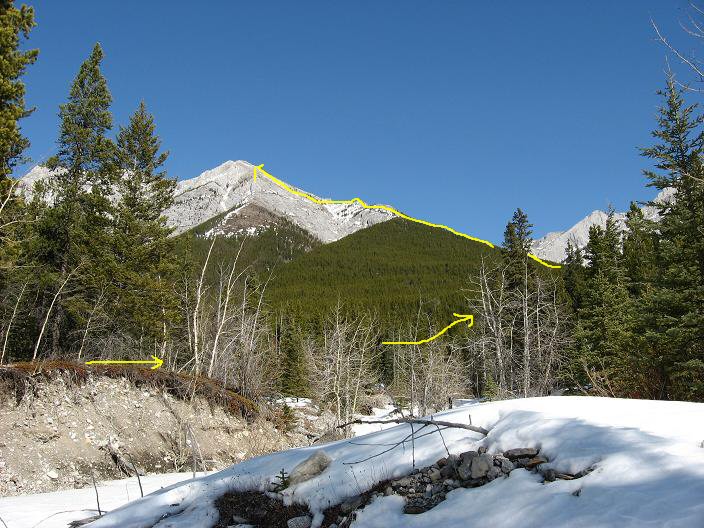
Looking up the drainage across from the highway 40 sign
View of basic route from the upper summit slopes, see the Nakiska turnoff
Gaining altitude as a nice view of The Wedge to the south appears
Trail through the trees has very infrequent flagging
Upper trail not to far from tree line
Yours truly almost to tree line
Yours truly again as nice views open up
Start of open ridge above tree line
Probably the one spot you approach the ridge on the right
Views mid way up the ridge
Some hands on mid way up the ridge
The last bit of the undulating ridge to the open summit slopes
A gauge of the final slope
Short rock step half minute before the true summit
Another view of the rock step
The summit appears, beautiful day
Summit views North, left of center is Mt Baldy
Summit views North Wasootch Peak - Kananaskis Scramble: Class 2 – Steep Hiking, Some hands on and route finding on the moderate open ridge just above tree line Altitude: 2,362m (7,747 ft) Elevation Gain: 916m (3,005 ft) Ascent Time: 2 – 3 Hours Best Season to Scramble: May to October, Dry Slopes, Possible Ticks in Spring Highlights This scramble is directly across from the Nakiska ski hill with outstanding views for the effort, probably can be done year round depending on snow cover in trees and if you have crampons and ice axe and help to break trail. My trip report was for March 22, 2008. Getting There Head west out of Calgary on the TransCanada highway # 1 to the Highway 40 Kananaskis Country turnoff (approx 59.7km from the Canada Olympic Park intersection to the Highway 40 turnoff). Take the turnoff and head south on highway 40 for approx. 23 km to the turnoff for the Kananaskis Inn and Nakiska Ski hill. Carefully turn around here and head back north up highway 40 for 300 metres and park in the right hand ditch (East side) near the "Highway 40" sign. The drainage at this sign is the start of the trail. If you want you can go 50 metres further and park in the ditch near the highway speed sign as the ditch is a bit flatter here. Route Description If you look up the creek bed near the highway 40 sign you can see the long trek through the trees to the open bumpy ridge on the right then the gradual left to the summit of Wasootch Peak. Start on the left side of the creek bed and after 5-10 minutes pick up a trail in the trees paralleling the creek on the left side. Follow this trail to tree line, tackle the moderate ridge head on with some hands on climbing usually staying left or on the center of the ridge. Once past the ridge you arrive at the final open slope to Wasootch Peak. The true summit is not visible but only a half a minute from the high point that you can see.
|