


End of US highway 302
|
Approx. time
period
|
East Terminus
|
West Terminus
|
|
1935-1960's (?)
|
Portland, ME (Deering)
|
Montpelier, VT (downtown?)
|
|
1960's (?)-present
|
Portland, ME (Forest)
|
Montpelier, VT (east)
|

(about 41 k)
Note: since I don't have access to a comprehensive
collection of historical road atlases, much of the info on this page
is based on the research of Robert Droz; click
here to view his site. Photo credits: Andy
Field; Doug
Kerr; Alex
Nitzman; me
US 302 was commissioned in 1935, and although its destinations
haven't changed since then, its west endpoint may have changed
slightly. It's always been in Montpelier VT; the photo below shows
today's west beginning as viewed from westbound US 2:
 Kerr, Nov. 2002
The photo above is looking north on River Street:
 Field/Nitzman, 2000
River takes a left at the intersection ahead (that road becomes
Berlin Street closer to downtown Montpelier), but then you're
westbound on US 2. However, this 1924 USGS map (pointed out by
Dan
Moraseski) indicates that the US 302 designation may have
originally been signed into downtown Montpelier:
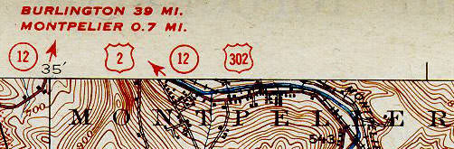
The "Y" junction where US 302 ends today is shown between the "L"
and the "I" in "MONTPELIER", right by the number "543" (downtown
Montpelier is just off the north edge of this quad, and unfortunately
I haven't seen a copy of that). The US 302 shield would seem to
indicate that the designation was co-signed with US 2 to the junction
with VT 12 downtown. So let's turn that way and see what we find:
 Field/Nitzman, 2000
That shows the junction where US 302 might have originally ended.
Or it may have continued to the right here with VT 12 (old US 2, now
Business 2) into downtown:
 Field/Nitzman, 2000
That's looking north on Main Street, where historic westbound US 2
split from VT 12. Heading the opposite direction on old US 2 (east on
State Street), signs for US 302 may have began to the right on Main
in the photo below...
 Field/Nitzman, 2000
...and the first reassurance market might have been here:
 Field/Nitzman, 2000
That's south on Main. Otherwise, signage may have begun a few
blocks further ahead, where US 2 splits off to the east on
Berlin:
 Field/Nitzman, 2000
That's approaching Berlin. At the intersection itself, it's signed
as if US 302 still does begin here, providing further evidence that
may have been the case in the past:
 Field/Nitzman, 2000
Below we're looking east on Berlin (modern US 2), approaching
Main:
 Field/Nitzman, 2000
Perhaps that was the west beginning of US 302. Ahead, we come to the modern
west beginning of US 302:
 Nitzman,
Aug. 2007
Nitzman,
Aug. 2007
That's looking east on River (US 2); the straight-ahead arrow says "RT2",
and the curve-right arrow says "RT302". If you take that right, you'll
soon see the first eastbound US 302 marker:
 Nitzman,
Aug. 2007
Nitzman,
Aug. 2007
The east endpoint in Portland
has definitely changed; you can view photos and get info on this
page.

Page created 24 August 2000; last updated 28 August 2007.
|