


End of historic US highway 152
|
Approx. time
period
|
North Terminus
|
South Terminus
|
|
1934-1938
|
Hammond, IN
|
Indianapolis, IN
|

(about 58 k)
Note: since I don't have access to a comprehensive collection of historical
road atlases, much of the info on this page is based on the research of Robert
Droz; click here to view
his site. Photo credits: Don
Hargraves
US 152 was an ephemeral little highway: an intrastate route - less
than 200 miles long - which lasted only about four years. According
to Stephen
Summers' website, the original north end of US 152 was at US 20
in Hammond, where IN hwy. 152 ends today:
 Hargraves, Nov. 2002
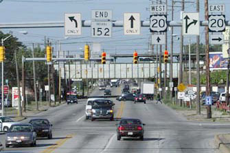
That's looking north on Indianapolis Boulevard at Michigan Street.
In the distance, behind the railroad bridge, you can just make out
the Indiana East-West Tollroad (I-90) viaduct. Below we're looking
the opposite direction, and you can see the backside of the sign
bridge:
 Hargraves, Nov. 2002
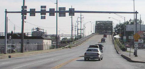
That's from the perspective of eastbound US 20, which continues to
the left here on Michigan. Ahead is the north beginning of IN 152 and
the historic north beginning of US 152. (The US 41 sign was for a
temporary detour.)
Apparently sometime before US 152 was completely decommissioned in 1938, its
north end was truncated to the same intersection near St. John IN that now marks
the north end of US
231 (view that page for photos).
The south end of US 152 was in Indianapolis. I can offer no explanation as
to why it was co-signed with US 52 from there to beyond Lafayette (a distance
of about 70 miles). The photo below is looking south on Lafayette Road:
 Google Maps
Street View, 2008
Google Maps
Street View, 2008
US 152 ended here at the intersection of 16th Street.

Page created 26 September 2002; last updated 28 April 2008.
|