


Historic US highways at Thistle, UT
Photo credits: me
When I was planning my visit to Thistle, I had to make the map below so that
I'd know what to look for, and where. Now that I'm putting up a webpage about
it, I realize it's pretty difficult to explain the situation there without a
map... so I'll start with this:

The background image is an aerial photo, with the USGS topo faintly showing
through. Thistle Creek and Soldier Creek converge down at lower left and become
the Spanish Fork River, which flows to the north. The original railroads and
highways through this area were built along these valleys. In 1926, US 89 was
designated to run north through Thistle and along the red dashed line (no longer
drivable) to the T-junction on the north side of Soldier Creek. At that point,
US 89 turned left and continued north, down the Spanish Fork valley. To the
right was the west beginning of the eastern segment of US 50. Two years later,
US 50 was extended west, down the valley with US 89. And then in 1937, the US
6 designation was extended through this area with US 50. In the 1970's, after
I-70 was built through Utah, the US 50 designation was changed to follow I-70.
But through all these route changes over the years, the historic road junction
itself remained pretty much the same.
However, in early 1983 a massive landslide came down in the area marked at
far left. It closed the highway, buckled the railroad tracks, and eventually
blocked the flow of the Spanish Fork. Snowmelt from the spring runoff quickly
backed up behind this natural dam, forming a lake that flooded and destroyed
the town of Thistle. Eventually a tunnel was dug to provide drainage for the
streams, but the canyon at the head of the Spanish Fork was no longer fit for
use as a transportation corridor. The area was closed for months as construction
crews worked frantically to complete new roads. A new tunnel was blasted through
the mountain for the railroad (actually two bores). US 6 had to be completely
rebuilt for a couple miles each direction from Thistle, in order to carry traffic
up and over a new mountain pass. US 89 traffic was then routed about two miles
east of Thistle (along what had been US 6) to meet the new US 6.
This was such a catastrophic event that hardly anything remains of either the
town or the nearby highway junction. There wasn't much left to photograph, but
what follows is my best attempt to document the old roads. The view below is
north on US 89:
 me, Oct. 2005
The town of Thistle once stood just off the left edge of the photo. Today,
northbound US 89 continues off the right side of the photo, gaining elevation
over the course of about a mile, until it reaches the new US 6. At that junction,
it turns left, and with westbound US 6 it passes behind the mountain visible
in that photo. However, before the slide, US 89 curved slightly left here. It
crossed Soldier Creek in the middleground, and then came to a T-intersection
at the foot of the mountain, right about in the center of that photo. US 89
continued by heading left off the edge of the photo. Below we're looking the
opposite direction (south on US 89)...
 me,
Oct. 2005
me,
Oct. 2005
...but until 1983, that was the perspective of a driver heading west on US
6 (and before that, west on US 50 as well). The highway went straight ahead,
toward the center of the photo, and then curved around the far side of the light-colored
mountain. Northbound US 89 - instead of curving around the corner at far left
and coming towards the camera - originally met US 6/50 near the center of the
photo, and then continued off the right side of the photo with those routes.
Below is a close-up:
 me, Oct. 2005
When the US routes were originally commissioned in 1926, US 50 went straight
ahead to about where those funny-looking things are located (that's a series
of interpretive signs which used to explain what happened at Thistle, but which
are now faded and/or vandalized beyond recognition). At that point, you were
at the west end of US 50 - if you continued ahead on the road that curved down
the canyon to the right, you would've been on northbound US 89. Or you could
make a left turn on southbound US 89, which crossed Soldier Creek and continued
up Thistle Creek. Below is a shot from a little further ahead:
 me,
Oct. 2005
me,
Oct. 2005
Today that's as far as you can go heading downstream on historic US 6/50/89.
The area immediately ahead is now used as a firing range for county law enforcement,
and about a half-mile ahead is where the landslide came down into the canyon.
The photo below was taken from about one mile ahead...
 me, Oct. 2005
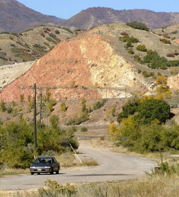
...although it takes about five miles of driving to get there now - you have
to go all the way around, using the new US 89. In that scene, the landslide
is right behind the camera, and we're looking down historic US 6/50/89. My car
is parked at the farthest point you can go heading upstream. Running across
the center of the photo is the new railroad (the old one was just off to the
left, on the opposite bank of the Spanish Fork). And above that, at far left,
you can see part of the new US 6/89. That same highway is also visible at upper
left of the photo below:
 me, Oct. 2005
That's looking the opposite direction (upstream on old US 6/50/89). The part
of the road with the centerline is new - it connects with the new US 6/89 off
to the left, and it allows access to the recreation area visible at right center
(Spanish Fork River Park). Behind that is a ridge, and behind that ridge is
where the landslide came down.

Page created 18 October 2005; last updated 19 October 2005.
|