 |
|
|
|
|
|
|
|
|
|
|
|
|
|
|
|
|
|
|
|
|
|
|
|
|
|
|
|
|
|
|
|
|
|
|
|
|
|
|
|
|
|
|
|
|
|
|
|
|
|
|
|
|
|
|
|
|
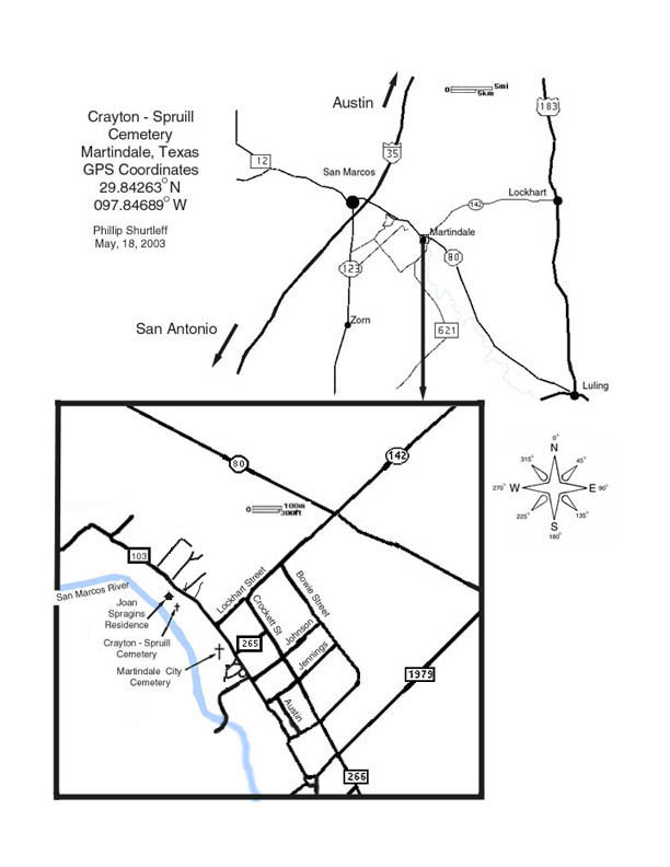
Crayton - Spruill Cemetery |
|
|
Main Page |
|
|
|
|
|
|
Martindale, Texas |
|
|
|
|
Go to page 2 |
|
|
|
|
|
|
GPS Coordinates in degrees |
|
|
|
|
Go to page 3 |
|
|
|
|
|
|
29.84263 N |
|
|
|
|
|
097.84689 W |
|
|
|
Updated 11-9-2006 |
|
|
|
Data collected by Phillip Shurtleff, Velma Fogle Shurtleff
and B.J. Crayton Peterson |
|
|
|
|
|
Descendants of John Crayton |
|
|
|
Care and data collection also provided by Alison Tutor |
|
|
|
May 18, 2003 |
|
|
|
John Crayton, his son James Lasater Crayton and their slaves emigrated to the Republic of Texas from Marion Co. Alabama in 1839.[1] They settled in what is now Martindale, Caldwell County. They were among the founders and builders of Caldwell County. The slaves (hands) of John Crayton helped build the first roads in Caldwell County.[2] The Spruill Family and their slaves emigrated to Martindale from Marion County, Alabama after 1850 and prior to January, 1856. |
|
|
|
The Crayton-Spruill Cemetery is a burying ground for Caucasians and African Americans. The first known burial in this cemetery is William W. Spruill who died Feb. 28, 1868. On January 12, 1871, John Crayton deeded the land to the San Marcos Missionary Baptist Church to be used for a church and a burying ground for colored and white people.[3] The colored persons were to be buried south of William Spruill's grave, the whites to the north of the same grave. The church was never built on this property but the congregation baptized for many years at the low water crossing and used the cemetery for burials. |
|
|
|
John Crayton fought in the War of 1812 as a volunteer in the E. Tenn. Militia.[4] He fought in the Mexican War from June 2, 1846 until Sept. 22, 1846.[5] He served in Co. K under Capt. Grumbles. There are four Masons buried in this cemetery. |
|
|
|
The cemetery has suffered from past vandalism , many tombstones are missing and the remaining ones were broken. Adrian White, a fifth generation descendant of John Crayton, repaired the broken ones and recovered from the ravine a number of tombstone bases from which the upper portions, bearing the names and inscriptions of the deceased, had been removed. On Mother's Day of 2002, Phillip Shurtleff, a seventh generation descendant of John Crayton, placed these bases at the top of several sunken areas that appeared to be graves. The bases are ornate which indicates the top portions were also ornate. |
|
|
|
The Crayton-Spruill Cemetery is not cared for by any association or committee. The Cemetery receives sporadic care from various descendants of John Crayton. The adjourning property owner Mrs. Joan Daily Spragins has been a friend, protector and advocate for the Cemetery since she and her husband C.E. built their home there in 1940. In early 2002, bad health caused Joan Spragins to move to a retirement home in Round Rock. The cemetery will miss her. |
|
|
|
|
|
|
[1] Vol. 15, page 893, Cattle Claim, Petition No. 115 in the Nueces County Courthouse, Corpus Christi , Tx. |
|
|
|
[2] Minutes: Caldwell County Commissioners Court Book A. Feb. Term 1855, Feb. Term 1856 |
|
|
[3] Hays Co. Deed Book M pages 409 & 410 |
|
|
|
[4] Tennesseans in the War of 1812 transcribed and indexed by Bryon & Samuel Sistler, page 147 |
|
|
Officers : CoL William Lillard & Capt. Thomas Sharpe |
|
|
|
[5]. Texas Veterans in the Mexican War--Muster Rolls of Texas Units page 69, No. 7 |
|
|
|
|
|
|
|
Plotting of the Crayton-Spruill Cemetery |
|
|
|
Click here to go to the map of grave locations updated Sept. 14, 2008. |
|
|
|
This data corrects errors made in an earlier plotting of the grave locations done by Phillip Shurtleff on June 25, 2002.Ā The measurements taken at that time were done with a hand held lenstatic compass and a 100' tape measurer.Ā These current measurements were taken by means of a protractor and string line mounted on top of a tripod and a 100' tape measurer. The protractor was set to magnetic North.Ā All measurements to the graves and other objects are bearing (in degrees) and distance (in feet and inches) from the tombstone of James W. Spruill. Global positioning measurements were made with a Magellan GPS 315 at the tombstone of James W. Spruill.Ā The known and suspected graves are mapped as large dots with a corresponding numbers underneath.Ā All other objects are mapped with smaller dots with corresponding labels above.Ā Trees are measured to their approximate trunk center at ground level.Ā CE 1, CE 2, CE 3, CE 4 and CE 5 are cedar elms.Ā Oak 1 and Oak 2 are live oak trees.Ā The rectangle with the corners labeled Fence 1, Fence 2, Fence 3 and Fence 4 is the metal fence surrounding the first 11 graves.Ā CFP 1, CFP 2 and CFP 3 are old cedar fence posts that may date back to when the cemetery was in use.Ā Old rusted barbed wire has been left laying as found as a clue to what may have been fenced in gravesites.Ā CFP 1 and CFP 2 are still standing, however CFP 3 has fallen and could have been moved from its original location.Ā Two of the sunken areas that are suspected graves, 12 and 23, have been marked by Phillip and Velma Shurtleff with Christian crosses made of pressure treated yellow pine and painted white.Ā More unmarked graves may lie in or beyond the plotted area.Ā Prior to the first plotting, the tombstone bases that had been moved from their original locations by vandals were place on suspected gravesites.Ā Graves 1 and 5 were marked in accordance with Joan Spragins recollection.Ā She is the great, great niece of Isabella Jennings: the wife of Luke Spruill. The grave of Isabella Jennings Spruill (grave 5) is now unmarked. |
|
|
|
Update October 30, 2005.Ā During the work of cutting in a roadway to the fenced area from the street, up to ten more gravesites were found lying to the Southeast beyond gravesite 12.Ā The locations of grave sites 25 through 32 were plotted with a magnetic compass and 100' tape measure. None had a complete tombstone bearing any markings except for the foot stone to grave 29.Ā Two were marked with the lower parts of a tombstone thus making the accompanying and nearby sunken areas likely gravesites.Ā Erosion of soil into the San Marcos River threatens most of these gravesites.Ā The erosion makes gravesite 32 unrecognizable as a gravesite, however the holes in the ground would be consistent with an animal having dug a burrow into a grave.Ā It could also be the root holes of a long rotted away lugustrom shrub as there is no sign of the shrub but the holes are are also consistent with deep root holes. Animal burrows appear next to more than one grave and there are several burrows in various areas of the cemetery. The burrows don't appear to absolutely consistent with a grave location but it may be that the animals have a preference for burrowing into a grave.
Small palm like plants are growing throughout this area of the cemetery in a manner indicating that they propagated from plants originally planted to decorate the graves.Ā These plants are not present elsewhere in the cemetery. These palm like plants may be Dracena Marginalis or Dracena Marginata but seem too small and scraggly. Both of these Dracena's can grow several feet high with straight stalks. The plants in the cemetery are growing along the ground and most are less than 18 inches in height from the ground but up to two or three feet in total length. Another candidate is Nolina Lindheimeriana; "Devil's Shoestring" but again the plants seem less robust than the Nolinas I saw in catalog photos. There is an area west of graves 27 and 25 that is fairly dense with these plants. They seem to have been moved there by run off water and taken root. |
|
|
|
Update September 23, 2006 After a meeting with a reporter from the Luling newspaper the locations of the above cemetery were plotted a second time using a magnetic compass and a 300' tape measure before updating the plotting map on page 2 B.J. Crayton Peterson found more cedar fence posts with barbed wire attached (CFP 4,5, 8, 9 and 10). These seem to mark the boundary of the original cemetery. Barbed wire is still attached to these posts and seems to run from CFP 4 to CFP 10 but is buried most of it's length. It might be worthwhile to follow the wire with a good quality metal detector. Posts 4,5 and 8 have fallen down and possibly moved from their original location. A small wad of fencing wire that held wood pickets about an inch and a quater wide and a half inch thick, which have long rotted away, was also found. It may be just old debris or it could be associated with another lost grave. A tombstone for A.J. Glover was found by B.J.in the ditch that borders the North and East sides of the cemetery. It has been placed inside the fenced grave area since there is no way to know where it originally stood. |
|
|
Update September 29, 2006 One more trip by Phillip Shurtleff to verify some of the measurements on graves 25 through 32 and on the recently discovered cedar fence posts resulted in finding two more ceder fence posts with barbed wire attached (CFP 6 and 7) and a sunken area marked as grave 33. Additionally two trees, the highest spot in the cemetery and the approximate edge of the San Marcos River were plotted. CFP 6 and 7 have fallen over some but are set in the ground indicating that they are still in their original location.
There are sunken areas that are indicitive of a long dead and rotted bush or tree. Sunken areas that are rectangular in shape and size one would expect to be the result of a collasping grave are marked as graves. Smaller, round sunken areas are not being marked as graves as that is what would be expected of a stump hole. The extensive erosion over most of the cemetery makes sunken areas over graves difficult to detect. |
|
|
Update October 29, 2006 A work day organized by Velma Shurtleff with several people attending resulting in the area from the drainage ditch to gravesites 12, 22, and 23 being clear of nearly all the lugustrum and a few unhealthy hackberry trees. The cuttings were pushed into the drainage ditch by B.J. and his front end loader to slow the flow of water and reduce the erosion of the cemetery. Seeding the newly cleared area with grass seed is in the future plans.
Also attending were three scuba divers that looked for artifacts that may have fallen or been tossed into the San Marcos River. Due to recent rains the sediment made the visibility along the bottom too poor to locate any objects. Another trip is planned when the visibility is better. |
|
|
B.J. and Helen Peterson from San Marcos, Texas
Alison Tudor and Parents; Wayne and Charlene Tudor from San Marcos, Texas
Velma Shurtleff and Phillip Shurtleff from Austin, Texas
Rania Kandil, Phillip Mishoe, Angie Cobb and Troy Najar from Austin, Texas |
|
Those attending this work day were:
Joe and Linda Strickland from Tioga, Texas
Rosemarie Strckland Myers from Odessa, Texas
Keith and Cindy Wooley from Delhi, Texas
Adrian White from Delhi, Texas
Ben Springer from San Marcos, Texas |
|
|
|
|
| Update November 8, 2006 Alison Tudor and Benton Springer dug up the tombstone base to grave 31 and find that it fits the dislodged tombstone section of A.J. Glover found in the drainage ditch by B.J.. Go to page three for photos. |
|
|
| Update April 14, 2007 B.J. Crayton Peterson, Allison Tudor, Keith and Cindy Woolly, Phillip and Velma Shurtleff clean tombstones and cleared land. A some point between April 07 and Nov. 06 Phillip Mishoe returned with fellow divers and pulled up a steel wagon wheel. Go to page three for photos. |
|
| Update May 26, 2008. A work day cleared more land and discoverd two more possible graves. A footstone (spot 35) and a sunken area (spot 34) were plotted. Some of the barbed wire from the original plotting was found to have been moved. As a number of people participate in cleaning, some potential artifacts get moved. Every attempt is made to plot newly found artifacts before there's any appreance of being moved. Plotted artifacts taht appear to have been previously moved are noted as such. Oak 2 was cut down to ground level as it seemed sickly and overly dominated by other trees. |
|
|
Update September 13, 2008. A work day was cancelled due to expected rains from Hurricane Ike. The rains were not forthcoming until very late that night. A short trip by Phillip and Velma Shurtleff was made to use a Ridgid See Snake Micro inspection camera with a six foot camera flex conduit to investigate the animal holes that were dug throughout the cemetery. none of the holes were found to go deeper than two or three feet and to be no more than about six feet in length. Most had filled back in. None seemed tohave come close to penetrating any grave assuming the graves are the standard six feet deep. |
|
|
|
 |
|
|
|
 |
|
| Above is an aerial photo of the area surrounding the Crayton - Spruill Cemetery.Ā The cemetery is concealed beneath a canopy of trees but Joan Spragins's residence is visible.Ā North is to the top. Similarly the photo below downloaded from Google Earth has been overlayed with the locations of the graves. James Spruill's Grave is located on the photo by a GPS feature associated with the Google Earth computer program. The grave locations were added in with the use of Photoshop 7. Go to the map of the grave locations. The grave locations are postioned according to magnetic north. The Google Earth image could be true North resulting in a error of 6 degrees in the grave locations with respect to the arieal photo. |
|
|
 |
|
|
|
Main Page |
|
Go to page 2 |
|
Go to page 3 |
|


