Virginia Ridge Lot #23

Jonah is standing in the middle of our road. The camera is looking
North. I've marked the North West Corner on the picture. The
lot marker for the South West Corner is just right of the picture.
Alpine sits in the nook of the mountains where Jonah's head is. The
homes to the North sit slightly below our lot's elevation. The green
stick marks where the water or sewer enters our lot.

I think I've mislabled the marker on this picture. I think this
is actually the North East Corner. The camera would be looking West
(slightly South). Anyway, this is Jonah with the West Mountains (and
Lehi) behind him). The Lake begins at the left of this picture.
Three blocks west of here (and down a decent slope) is a 800 acre protected
preserve that American Fork owns It will never be developed because
it is a water shed area.

The camera is facing South (slightly East). Jonah is standing
by the North West Corner Marker for our lot (the orange flag). The
red flag indicates where the sidewalk will run. If this shot were
clear you could see all the way to Payson. American Fork sits down
below the hill. All of our utility boxes are now where Jonah was
standing. They will be building a new church in the South East corner
of the subdivision (where the land meets the houses on the left side of
the picture). We'll be able to walk to church.
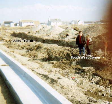
They finally got the curb and gutter put in. The Utility Trench ends at the North West Corner of our lot (you can see it if you follow the shadow of the Utility Trench). The Camera is facing North East. Noah and Jonah are standing next to the South West Corner Marker (orange flag). The homes in this picture are still in American Fork. If you go three more narrow blocks north, you would be in Highland. Their Elementary school is about 1/2 mile North East of here. It will be a mile walking, though, because there is no outlet from our subdivision in the North East corner.