|
|

 |
The Jordan Valley |
|
|
|
The Jordan Valley,
which extends down the entire western flank of Jordan, is
the country's most distinctive natural feature. The Jordan
Valley forms part of the Great Rift Valley of Africa, which
extends down from southern Turkey through Lebanon and Syria
to the salty depression of the Dead Sea, where it continues
south through Aqaba and the Red Sea to eastern Africa. This
fissure was created 20 million years ago by shifting tectonic
plates.

The
River Jordan
© Jordan Tourism Board
The
northern segment of the Jordan Valley, known in Arabic as
the Ghor, is the nation's most fertile region. It contains
the Jordan River and extends from the northern border down
to the Dead Sea. The Jordan River rises from several sources,
mainly the Anti-Lebanon Mountains in Syria, and flows down
into Lake Tiberias (the Sea of Galilee), 212 meters below
sea level. It then drains into the Dead Sea which, at 407
meters below sea level, is the lowest point on earth. The
river is between 20 and 30 meters wide near its endpoint.
Its flow has been much reduced and its salinity increased
because significant amounts have been diverted for irrigational
uses.
Several degrees warmer than the rest of the country, its year-round
agricultural climate, fertile soils, higher winter rainfall
and extensive summer irrigation have made the Ghor the food
bowl of Jordan.
The Jordan River ends at the Dead Sea, which, at a level of
over 407 meters below sea level, is the lowest place on the
earth's surface. It is landlocked and fed by the Jordan River
and run-off from side wadis. With no outlet to the sea, intense
evaporation concentrates its mineral salts and produces a
hypersaline solution. The sea is saturated with salt and minerals–its
salt content is about eight times higher than that of the
world's ocean–and earns its name by virtue of the fact
that it supports no indigenous plant or animal life. The Dead
Sea and the neighboring Zarqa Ma'een hot springs are famous
for their therapeutic mineral waters, drawing visitors from
all over the world.

Dead Sea at night.
© Zohra
South
of the Dead Sea, the Jordan Valley runs on through hot, dry
Wadi ‘Araba. This spectacular valley is 155 kilometers
long and is known for the sheer, barren sides of its mountains.
Its primary economic contribution is through potash mining.
Wadi ‘Araba rises from 300 meters below sea level at
its northern end to 355 meters above sea level at Jabal Risha,
and then drops down again to sea level at Aqaba.
The seaside city of Aqaba is Jordan's only outlet to the sea.
Its 40 kilometer-long coastline houses not only a tourist
resort and Jordan's only port, but also some of the finest
coral reefs in the world. The rich marine life of these reefs
provides excellent opportunities for snorkeling and diving.
|
|
|
|
|
The Mountain Heights |
|
|
|
The
highlands of Jordan separate the Jordan Valley and its margins
from the plains of the eastern desert. This region extends
the entire length of the western part of the country, and
hosts most of Jordan's main population centers, including
Amman, Zarqa, Irbid and Karak. We know that ancient peoples
found the area inviting as well, since one can visit the ruins
of Jerash, Karak, Madaba, Petra and other historical sites
which are found in the Mountain Heights Plateau. These areas
receive Jordan's highest rainfall, and are the most richly
vegetated in the country.

Wadi
Mujib.
© Jad Al Younis, Discovery Eco-Tourism
The
region, which extends from Umm Qais in the north to Ras an-Naqab
in the south, is intersected by a number of valleys and riverbeds
known as wadis. The Arabic word wadi means a watercourse valley
which may or may not flow with water after substantial rainfall.
All of the wadis which intersect this plateau, including Wadi
Mujib, Wadi Mousa, Wadi Hassa and Wadi Zarqa, eventually flow
into the Jordan River, the Dead Sea or the usually-dry Jordan
Rift. Elevation in the highlands varies considerably, from
600 meters to about 1,500 meters above sea level, with temperature
and rainfall patterns varying accordingly.
The northern part of the Mountain Heights Plateau, known as
the northern highlands, extends southwards from Umm Qais to
just north of Amman, and displays a typical Mediterranean
climate and vegetation. This region was known historically
as the Land of Gilead, and is characterized by higher elevations
and cooler temperatures.
South and east of the northern highlands are the northern
steppes, which serve as a buffer between the highlands and
the eastern desert. The area, which extends from Irbid through
Mafraq and Madaba all the way south to Karak, was formerly
covered in steppe vegetation. Much of this has been lost to
desertification, however. In the south, the Sharra highlands
extend from Shobak south to Ras an-Naqab. This high altitude
plain receives little annual rainfall and is consequently
lightly vegetated.
|
|
|
|
|
The Eastern Desert (Badia) |
|
|
|
Comprising
around 75% of Jordan, this area of desert and desert steppe
is part of what is known as the North Arab Desert. It stretches
into Syria, Iraq and Saudi Arabia, with elevations varying
between 600 and 900 meters above sea level. Climate in the
Badia varies widely between day and night, and between summer
and winter. Daytime summer temperatures can exceed 40°C,
while winter nights can be very cold, dry and windy. Rainfall
is minimal throughout the year, averaging less than 50 millimeters
annually. Although all the regions of the Badia (or desert)
are united by their harsh desert climate, similar vegetation
types and sparse concentrations of population, they vary considerably
according to their underlying geology.
The volcanic formations of the northern Basalt Desert extend
into Syria and Saudi Arabia, and are recognizable by the black
basalt boulders which cover the landscape. East of the Basalt
Desert, the Rweishid Desert is an undulating limestone plateau
which extends to the Iraqi border. There is some grassland
in this area, and some agriculture is practiced there. Northeast
of Amman, the Eastern Desert is crossed by a multitude of
vegetated wadis, and includes the Azraq Oasis and the Shomari
Wildlife Reserve.
To the south of Amman is the Central Desert, while Wadi Sarhan
on Jordan's eastern border drains north into Azraq. Al-Jafr
Basin, south of the Central Desert, is crossed by a number
of broad, sparsely-vegetated wadis. South of al-Jafr and east
of the Rum Desert, al-Mudawwara Desert is characterized by
isolated hills and low rocky mountains separated by broad,
sandy wadis. The most famous desert in Jordan is the Rum Desert,
home of the wondrous Wadi Rum landscape. Towering sandstone
mesas dominate this arid area, producing one of the most fantastic
desert-scapes in the world.
|
|
|
|
|
Wildlife
and Vegetation |
|
|
|

Arabian
Oryx at the Shomari Reserve.
©
Jordan Tourism Board
Throughout
history, the land of Jordan has been renowned for its luxurious
vegetation and wildlife. Ancient mosaics and stone engravings
in Jawa and Wadi Qatif show pictures of oryx, Capra ibex and
oxen. Known in the Bible as the "land of milk and honey,"
the area was described by more recent historians and travelers
as green and rich in wildlife. During the 20th century, however,
the health of Jordan's natural habitat has declined significantly.
Problems such as desertification, drought and overhunting
have damaged the natural landscape and will take many years
to rectify.
Fortunately, Jordanians have taken great strides in recent
years toward stopping and reversing the decline of their beautiful
natural heritage. Even now, the Kingdom retains a rich diversity
of animal and plant life that varies between the Jordan Valley,
the Mountain Heights Plateau and the Badia Desert region.
|
|
|
|
|
|
|
The
Jordanian habitat and its wildlife communities have undergone
significant changes over the centuries and continue to be
threatened by a number of factors. A rapidly expanding population,
industrial pollution, wildlife hunting and habitat loss due
to development have taken a toll on Jordan's wildlife population.
Jordan's absorption of hundreds of thousands of people since
1948 has resulted in the over-exploitation of many of its
natural resources, and the country's severe shortage of water
has led to the draining of underwater aquifers and damage
to the Azraq Oasis.
In recent decades, Jordan has addressed these and other threats
to the environment, beginning the process of reversing environmental
decline. A true foundation of environmental protection requires
awareness upon the part of the population, and a number of
governmental and non-governmental organizations are actively
involved in educating the populace about environmental issues.
Jordan's Ministry of Education is also introducing new literature
into the government schools' curriculum to promote awareness
of environmental issues among the young students.
The National Strategy presents specific recommendations for
Jordan on a sectoral basis, addressing the areas of agriculture,
air pollution, coastal and marine life, antiquities and cultural
resources, mineral resources, wildlife and habitat preservation,
population and settlement patterns, and water resources. The
plan places considerable emphasis throughout on the conservation
of water and agriculturally productive land, of which the
contamination or loss of either would bring swift and significant
consequences to Jordan.
|
|
|
|
|
|
|
The
gravest environmental challenge that Jordan faces today is
the scarcity of water. Indeed, water is the decisive factor
in the population/resources equation. Whereas water resources
in Jordan have fluctuated around a stationary average, the
country's population has continued to rise. A high rate of
natural population growth, combined with periodic massive
influxes of refugees, has transformed a comfortable balance
between population and water in the first half of this century
into a chronic and worsening imbalance in the second half.
The situation has been exacerbated by the fact that Jordan
shares most of its surface water resources with neighboring
countries, whose control has partially deprived Jordan of
its fair share of water. Current use already exceeds renewable
supply. The deficit is covered by the unsustainable practice
of overdrawing highland aquifers, resulting in lowered water
tables and declining water quality. On a per capita basis,
Jordan has one of the lowest levels of water resources in
the world. Most experts consider countries with a per capita
water production below 1,000 cubic meters per year to be water-poor
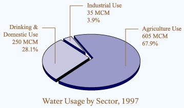
countries. In 1997, Jordanians consumed a total of 882 million
cubic meters (MCM). In 1996, per capita share of water was
less than 175 for all uses. This placed Jordan at only 20
percent of the water poverty level. The extent of the crisis
is further demonstrated by the fact that, from the 1997 total
of 882 MCM, around 225 MCM was pumped from ground water over
and above the level of sustainable yield. Likewise, about
70 MCM was pumped from non-renewable fossil water in the southeast
of the country.With Jordan's population expected to continue
to rise, the gap between water supply and demand threatens
to widen significantly. By the year 2025, if current trends
continue, per capita water supply will fall from the current
200 cubic meters per person to only 91 cubic meters, putting
Jordan in the category of having an absolute water shortage.
Only two years from now, in the year 2000, Jordan is expected
to require 1257 MCM of water to cover minimum domestic, industrial
and agricultural needs. Quantities from sources available
by that time will not exceed 960 MCM, bringing the deficit
to 297 MCM. Of the required total, 61 percent will be needed
to maintain existing agricultural activities, 31 percent for
domestic consumption, and six percent for industrial uses.Responding
to the challenge, the government has adopted a multi-faceted
approach designed to both reduce demand as well as increase
supply. The peace treaty signed in 1994 by Jordan and Israel
guaranteed Jordan its right to an additional 215 MCM of water
annually through new dams, diversion structures, pipelines
and a desalination/purification plant. Of this 215 MCM, Jordan
is already receiving between 55 and 60 MCM of water from across
the border with Israel through a newly-built pipeline. Jordan
is also entitled to build a series of dams on the Jordan and
Yarmouk rivers to impound its share of flood waters. To this
end, the Karama Dam in the Jordan Valley has been built to
store 55 MCM of water, mainly from the Yarmouk, and its yield
will be used to help irrigate some
6000 hectares in the southern Jordan Valley.
|
|
|
|
|
|
