HOME
For a few pages of links to English language resources on Korea and Korean issues, Click Here
HISTORICAL MAPS
Korea Through Western Cartographic Eyes
Old Maps of Korea (From a site devoted to Hendrick Hamel)
More
Korean War Maps (From the U.S. Army Center of Military History)
Korean War Maps, with airfields (From the Korean War Project)
Korean War Maps (From U.S. Military Academy West Point Map Library)
Korean War Maps (From PBS Special on McArthur)
Korean War Maps (From Ebb and Flow: November 1950-July 1951, and Truce Tent and Fighting Front)
Korean War Maps (Library of Congress Collection, from Korean War Project)
Korean War POW Maps (From History of United States Naval Operations: Korea (Naval Historical Center)
GENERAL MAP SITES
Modern and Historical Maps (From Perry-Casta?da Library Map Collection)
Interactive Map of South Korea (From Korean National Tourism Organization)
Zoomable Map of Korean Peninsula (1986, CIA, In Library of Congress)
Zoomable Map of Korean Peninsula (1987, CIA, In Library of Congress)
Various Maps and Map Pages (From EmbassyWorld.com)
Maps of Korea (From DPRK - NORTH KOREA, maintained by Tim Beal, Victoria University of Wellington, New Zealand)
Oceanographic Atlas of Korean Waters (From KORDI)
REGIONAL AND LOCAL MAPS
Korea Provinces Map
Maps of and near Pusan/Busan (From PusanWeb)
Interactive Map of Seoul (From Korean National Tourism Organization)
Interactive Map of Chollanam-do/Jeollanam-do (From Korean National Tourism Organization)
North Korea Maps (From About.com)
Korean Provincial Maps (From Chosun Sinbo (People's Korea, a North Korean paper based in Japan) Note that several South Korean provinces are combined rather than split into North and South proivinces.)
North and South Hamgyong Provinces
Ryanggang Province
Chagang Province
Pyongan Province
Hwanghae Province
Kangwon Province
Kyonggi Province
Chungchong Province
Kyongsan Province
Cholla Province
Cheju Island
South Korea Subway Maps (may be out of date)
Seoul Subway Map (From world-cup-info.com)
Pusan (Busan) Subway Map (From world-cup-info.com)
Daegu Subway Map (From world-cup-info.com)
Daejeon Subway Map (From world-cup-info.com)
Kwangju (Gwangju) Subway Map (From world-cup-info.com)
Inchon (Incheon) Subway Map (From world-cup-info.com)
More maps
KAL Domestic Flight Connections (collected by http://www2.gol.com/users/graham/index.html Graham H. Watt)
South Korean Rail Lines (collected by http://www2.gol.com/users/graham/index.html Graham H. Watt)
Inter-Korean rail links (PDF format, from the Schiller Institute)
Korean Airport Locations (From KAC)
KTX Routes
UNUSUAL OR OTHERWISE INTERESTING MAPS
Perceptual Dialect Maps of Korea - "Most Pleasant" Speech Areas
Korea Maps from ReliefWeb
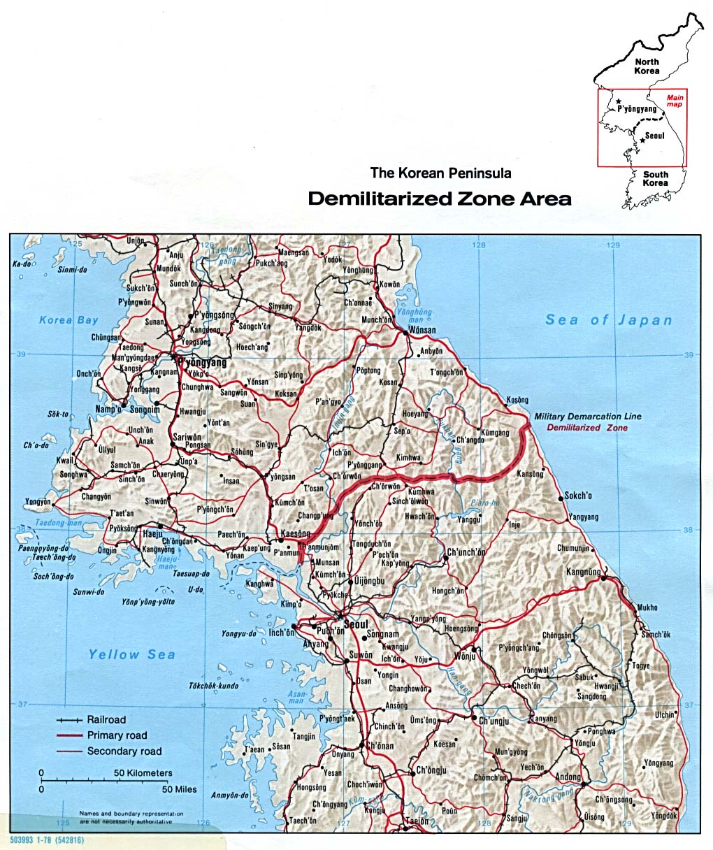
Post Korean War-era DMZ maps
Location of former U.S. military bases near DMZ over time (Scroll down)
DMZ near Panmunjom, circa 1976 (from Imjin Scout)
Map of Panmunjom used during Operation Paul Bunyan (from Imjin Scout)
Joint Security Area in Panmunjom (From Life In Korea)
KEDO Nuclear Reactor Site (From KEDO)
Yongbyon Nuclear Facility (Satellite Picture, from CNS)
(For Larger Version)
Map of Suspected Uranium Enrichment Sites in North Korea (From CNS)
Map of Mining and Milling Facilities in North Korea (From CNS)
North Korean Nuclear and Nuclear Related Facilities (From CNS)
North Korean Missile Bases (From CNS)
North Korean Missile Production Facilities (From CNS)
North Korean Dual Use Chemical Facilities (From CNS)
North Korean Chemical Warfare Military Installations (From CNS)
North Korean Chemical Weapons Production and Storage Facilities (From CNS)
North Korean Chemical Wespons Research and Development Sites (From CNS)
North Korean Biological Weapons Sites (From CNS)
North Korean Dual Use Bio-Tech Sites (From CNS)
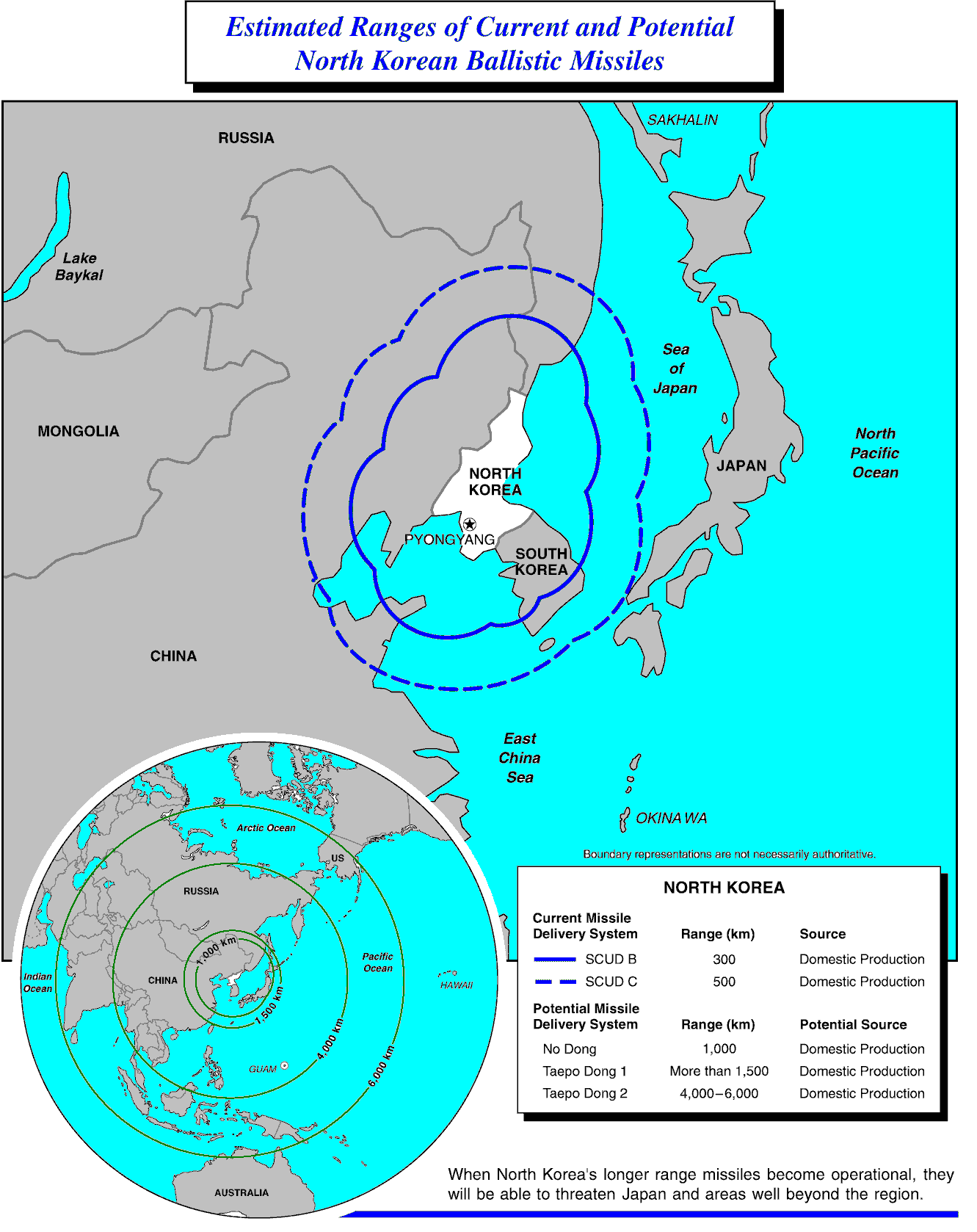
North Korean Missile range Map (From FAS)
Satellite Images of North Korea's Musudan Facility (From FAS)
DMZ Map (From the University of Texas Map Library)
Mount Kumkang (Kumgang/Keumkang/Keumgang)
Mount Kumkang area (From Hyundai Asan)