THE NEW YORK
DEER
Learn about the diversity of the New York deer and hunting oppurtunities

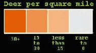
This map shows New York from about the center line and to the west. To the right of Lake Ontario (with the border going through it) is the tug hill plateau ( dark brown before the mountains to the east), also note that the southern portion of the state is also quite hilly. This is not the way that most of the country views New York State. Our camp is on the highest part of the tughill plateau. When the cold air blows from the west (primary direction of wind is from the west), over the relatively warmer lake it picks up moisture, which causes lake effect snow. Because of the "lift" over the tughill this moisture is enhanced further over the hill. The area AVERAGES over 300 inches of snow a year because of it. My home which is to the SE of Lake Ontario ( and north, slightly, of Oneida Lake{small lake shown on this map}), normally receives over 100 inches a year. Because of the very harsh winter conditions the losses of white tail deer are some times staggering with some years seeing a 90% loss of the yearlings in the herd. This can be noted on the deer density map below. The larger, stronger deer survive the winter. Although the density is not great, many trophy deer are taken in the northern section of the state. That is why the lighter shaded area on the map below is essentially "Northern Tier".
This map is the courtesy of "DEVO" - he has a great page and the link to his New York information (and others) is linked here.

| |

This Page Hosted By GeoCities. Get Your Own Free Home Page.