
The trail up Garfield Peak to the fire tower at its summit is among the longest of Crater Lake National Park's groomed trails. It would be the most strenuous, but for the 700-foot straight-down trail to the edge of the boat launch in the crater itself. Mount Scott, however, rises to 8,051 feet, so the altitude itself can pose a challenge for coastal-dwellers like myself. When Chris and I camped in Crater Lake in August 1995, we began the Garfield hike around 9 a.m., ate lunch at the summit, and returned to the trail-head by mid-afternoon. Normally we do two hikes a day while camping, but I was too exhausted to do more than return to camp and catch up on some reading.
The trail up Garfield Peak begins just east of the newly-renovated lodge on the South edge of Crater Lake. The first part of the trail cuts across a meadow while following the general line of the cliffs above the lake. At this point on the trail, expect to encounter short-distance hikers setting out for views over the lake. Soon the hike turns east, away from the lake, and begins a steady upward stretch. Not too far up the trail, you encounter your first switch-back. Resist the urge to take short-cuts: past hikers have caused plenty of erosion already. In any case, the hike now becomes nothing but switchbacks for an hour of steady hiking, so you want to conserve your energy.
As the trail reaches upper elevations, views out over the Cascades will open up below you. On a clear day, you can see as far south as Mount Shasta, and--if I remember correctly--there were at least three other snow-covered peaks to the south and east. At the summit, of course, you will have views to the north as well: the backbone of the Cascades wending its way toward Seattle. Even without the need to drink frequent water and catch my breath, I would have lingered on this trail. And there were rewards other than the view: half-way up, Chris and I noticed a small dream-catcher dangling from a scraggly tree below the trail.
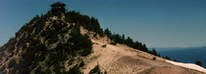
Very few people in the park go more than a half-mile up the trail, so you will probably experience the views almost undisturbed. As you near the top, though, the few hikers on the trail with you are likely to become more noticeable. You will encounter people on a ridge about a mile below the summit, branching off on the left side of the trail. You can stop to enjoy views down to the lake, including the tiny people at the look-outs near the lodge. Observe the warning signs and stay well back from the edge. At the very top you are likely to encounter hikers, as well, most of them enjoying picnic lunches or exploring the fire-tower. (The tower was locked the day we made the hike, but that didn't stop people from trying to find a way in.) Even in August, snow fields and the sharp drops off the trail limit space at the top of Garfield Peak.
I am afraid of heights, and the relatively narrow path across the last stretch of the trail gave me a few moments of fear. Really, though, this is an entirely manageable hike, and worth the trip. Carry lots of water, and be prepared for temperature changes: you will want an extra layer when you reach the top, especially if you plan to linger and enjoy the views.
Visit the National Park Guide
![]()
![]()
![]()
![]()
![]()
![]()