
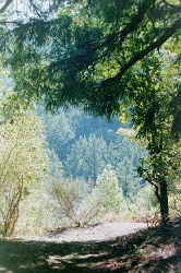
I hiked a 5.5 mile hike through Sanborn-Skyline with my friend Brian in early October 1997. It was a crisp, clear morning and a gorgeous day for a hike. Unlike most hikes on the skyline ridge of San Francisco's south bay, Sanborn lacked the dry grasslands I expect. Instead, the fog that regularly creeps over the ridges from the Pacific feeds a lush micro-climate of moss-draped rocks and trees along a damp trail tucked above the second-growth redwood canyons and broad expanses of madrone on the hike's back stretch.
 Brian and I parked at the first car lot near the entrance, although the trail does not begin until the walk-in campground at the top of the picnic grounds. If you park near the campground, you will have to cut across the picnic ground at the end of the hike (but we lost the trail before the theater at the end of the trail in any case: there is no reason not to wander through the park at that point).
Begin the trail on the paved walk behind the RV lot, walking past the restroom and then turning left. This takes you up the hill and through the campground. There are 33 campsites by our count, all with fire rings and water spigots; some of the sites have picnic tables and there is a group site at the top of the campground. There were no campers when we made the hike, so we were able to enjoy the thick tree cover and the chill to the air in our upward climb. Bring your own water if you camp here, because the water at the restroom tastes foul.
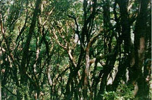
The real hike begins at the top of the campground, beyond the group site, when the Sanborn trail branches off to the right. The trail is clearly marked by signs; it continues through thick trees, including many second-growth redwoods, as it climbs up a canyon. In the spring, it appears hikers would have to cross several run-off streams, so wear boots if the weather has been wet.
 This first half of the hike goes uphill at a steady pace, but eventually there's a temporary levelling as the trail leads out of the canyon and onto an oak-covered hillside. Take advantage of a loop to the left off the main trail to get a view of the lower Bay. Further up the trail, near a large oak growing off the trail at the end of a rapid uphill, look behind you for a view of the sprawling city of San Jose.
Although the trail appears to be leveling out near the lookout, in fact we now entered the most enjoyable stretch of the trail for me, the moss-covered rainforest below the skyline trail. After about a half-mile of generally upward switchbacks, the trail angles right and begins to descend again. Hikers wanting to extend the hike or link to the Skyline trail should watch for the turn-off. Eventually the trail will descend into madrone, beautiful in the late-morning sunshine of autumn when Brian and I were there.
Toward the end of the hike, follow signs for the parking lot in order to avoid getting turned around. At one point, Brian and I ignored an unmarked left branch to the trail and, after passing through a meadow of abandoned maintenance supplies, lost the trail completely. At this point, we made our way back to the picnic grounds on the maintenance roads: we should have taken that unmarked fork. The map provided at the park entrace, by the way, was singularly unhelpful.
You can reach Sanborn-Skyline via Sanborn road off Highway 9, which runs through downtown Saratoga. The campsite is open to tent campers from the last weekend in March to October 15; RV campers are welcome year-round. There is an entrance fee, and no parking on the street for those who want a short walk in. Unlike many of the other trails I've hiked in the area, Sanborn-Skyline did not attract many hikers: we passed four people along our route.
Before you go, a final word of advice. Brian wrote a neat poem about another hike in the south bay, titled "Arastradero, A Hike to Lap". Go read it, maybe even out loud. Arastradero, by the way, provides some of those grassland hikes I expected to find at Sanborn.
Visit the Santa Clara County Park Guide
![]()
![]()
![]()
![]()
![]()
![]()