|
|
| New Smyrna Multiuse Spruce Creek Preserve Terrain: Twisty singletrack along the banks of Spruce Creek good for all skill levels. There is a wide main trail good for beginners, while other sections are manageable by beginners. Trails are somewhat typical for Florida in that that there is about 30 feet of elevation change throughout the preserve and some sandy areas. Skill To Get There: Take I-95 to New Smyrna Beach, just south of Daytona Beach, and take SR 44 East. Go under I-95 and turn left on Sugar Mill Drive, then left on Pioneer Trail. Turn right on Turnbull Bay and left on Martin Dairy Road, which is the first dirt road on the left. Continue on Martin Dairy Road for about one mile and park by the kiosk and trails going off into the woods to the North. You can click, pan, and zoom on the map below.
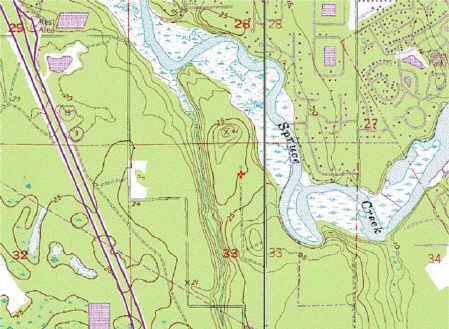
Spruce Creek has experienced pressure from development. Volusia county had the foresight to preserve some sections of Upper Spruce Creek from urban encroachment. The result is a 2000+ acre preserve has approximately 10 miles of fun singletrack and is open to cyclists, hikers, and equestrians. Keep in mind that cyclists must yield to hikers and equestrians, and equestrians must yield to hikers. Be considerate to other trail users.
I recommend mountain bikers take a clockwise loop. Start by going to the left of the kiosk and whenever you reach a junction, turn left! Once you reach the powerlines, this rule of thumb doesn't hold true. There are difficult sections of very soft sand once you reach the powerlines (known as the Never Ending Trail), so you may consider bypassing this section. If you choose to continue across the powerlines, the left hand rule will lead you to a couple of dead-ends (which are fun offshoots themselves). Eventually, you'll return to the entrance. I recommend hikers take a counterclockwise loop. Start by going to the right of the kiosk and continue from there. I suggest opposing routes for cyclists and hikers for two reasons. One, it is easy to see oncoming trail users. Two, the upward slopes are slightly more gentle for cyclists so those with less skill do not have to walk. Hikers will get to walk down gentle slopes, and avoid slippery descents. An contour map is shown below and generally the steeper slopes are near the waterways.
A few other things to note. Biting flies occupy the sandy sections. So ride quickly through the sand unless you enjoy being bitten! Those biting bugs will draft behind your legs and get you if you're too slow! Most trails are shaded by pine forest, but you'll mostly battle the high humidity in the summer. There are no facilities, so bring lots of water, food, and insect repellent. Parking can be limited on weekends during cool seasons. The trails are not blazed, but are easy to follow. There should be maps available on the kiosk.
|