The central theme of this article is that Mussolini violated the Italy-Ethiopian treaty of 1902 when he unilaterally advanced the Eritrean frontier to the Tekezze-Tomsa river junction as shown in the Italian maps of the time. The Italians never physically occupied this area (the Badime region was largely a wilderness at the time). Therefore, there was no Wal-Wal type incident (1934) with Ethiopia in this region.
The Eritrean government insists that the frontier must be drawn according to the Italian map created by Mussolini in 1934. They do not appear to care that the Mussolini map violates the 1902 treaty. That is why they have invaded the disputed region with their army, thus bringing under Eritrean control territory that even Mussolini never occupied.
|
July 11, 1998 The Italo-Ethiopian Treaty of 1902 is the treaty that defined the border between Eritrea and Ethiopia from Sudan to the Mareb-Mai Ambessa junction. As discussed previously, this treaty is extremely short and vague. In addition, the delimitation was never completed. The Eritrean government and its supporters deny this, but every reader can check the treaty for themselves (at least the english version). Recently I came across an Italian military map which is part of a book written by the commander of the Italian forces during the invasion of Ethiopia in 1935. | ||
|
The title page of this book is shown at the right. The book includes several detailed military maps showing the positions of the Italian and Ethiopian forces during the war of 1935-1936. Several of the maps show the Eritrea - Ethiopia border in detail. Italy had embarked on a large aerial photography mapping program prior to the invasion of Ethiopia, and these maps are probably the most detailed available. When I looked at these maps I could not find an exact match to the critical features mentioned in the Italy - Ethiopia treaty of 1902. Specifically, Mount Ala Tacura, and the MaiTeb river. I did find however, a location labeled with "LACATACURA" and another labeled "Mai Tab." These are located much further west than Eritrea's claims. |
| |
|
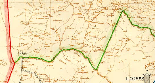
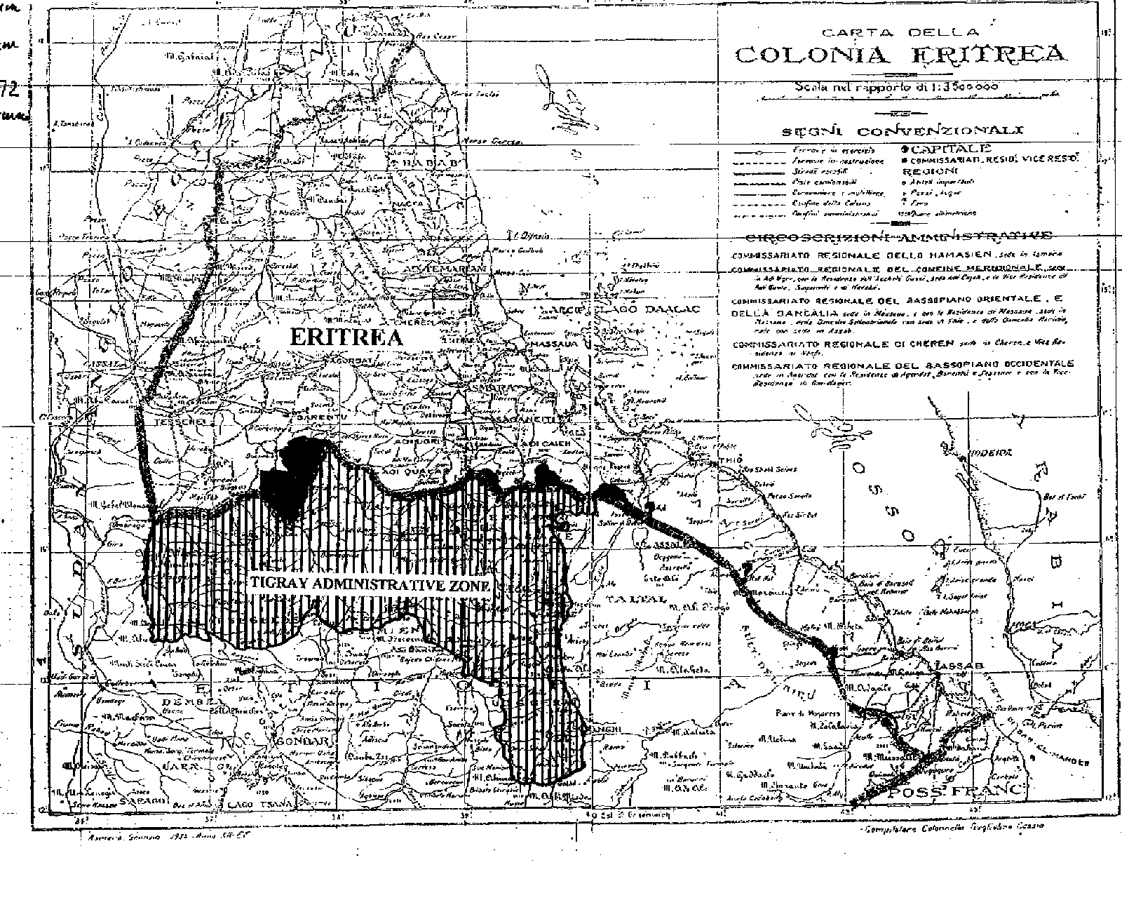
Below, I have listed some closeups from the maps. I have also listed the "Carta Della Colonia Eritrea," which the Eritrean government released. Look closely to see the areas marked "Lacatacura" and "Mai Teb" - They are the same as marked on the Italian military maps. In addition, one can examine the older "Carta Dimonstrativa" which appears to have "Lacatacura" and "Etana" marked. It is not clear when the Carta Dimonstrativa was marked up, but it has no legal basis, and is hopelessly inaccurate as explained below.
Observations.ĀĀ From the above maps the following is clear: 1. The border was supposed to leave the Setit river at its junction with the Maieteb. The Tigre-inhabited areas were supposed to remain in Ethiopia, and the border was to follow the Maieteb so as to leave the LACATACURA hills in Eritrea. The area marked as "LACATACURA" is clearly a mountain that causes the Setit to dip southward and flow around it. A look at a topographic map of Ethiopia shows this. By contrast, there is no truly distinct "mountain" where Eritrea claims the border should be. Instead, the plain slopes west from the higher plateau in Ethiopia. 2. The Italians violated the treaty and pushed the border (on their maps) to the junction of the Tekezze and Tomsa rivers. The Italians knew that the name of the Setit river changes to the Tekeze along the area marked as "Bircutan." The treaty does not mention the Tekezze; it mentions the Setit. The Italians knew the difference as shown on the map. They also knew the difference between the Gash river and the Mareb river. 3. The Italians initially appeared to use the Etana river as the boundary (see the Carta Dimonstrativa). It is unclear what basis they have for doing that. They later pushed the border further southwest to the Tomsa. The Etana joins the Sittona before joinning the Setit (see Tomsa-Tekezze closeup). 4. The Carta Dimonstrativa is mentioned in the 1900 treaty but not in the 1902 treaty. It is also full of errors. It shows the Mai-Ambessa - Mareb junction in the wrong place. This can be ascertained by looking at the 14th parallel and the 18th longitude lines. 5. Concerning the Kunama population, it appears that most of the areas under contention today were wilderness land and not populated. In the south is a wildlife sanctuary which even today contains elephants. At the time of the 1902 treaty, the entire Kunama population probably numbered less than 20,000, with their main center lying at Barentu, (north of the Gash river). The lack of villages on the maps indicates the continued low population in 1935. Italian Dishonesty towards Ethiopia - The Treaty of 1906.ĀĀ What were the Italians doing? Well, we need to understand the thinking of the Europeans at the time. They believed that there would be a new opportunity to colonize Ethiopia when Menelik died. Therefore, Italy, France and Britain signed a treaty in 1906 that described their respective interests in Ethiopia and recognized that Italy was to be given primacy regarding Ethiopia. The 1906 treaty also specified that military action against Ethiopia would be carried out jointly by all three European nations. Looking back in 1932, an Italian official wrote that the 1906 agreement constituted the "magna charta" of Italian aspirations in Ethiopia. Italian Dishonesty towards Ethiopia - Wal Wal.ĀĀ Wal Wal is located inside Ethiopia, well west of the Italian Somaliland border of the time. The Wal Wal incident occurred in 1934, but as early as 1928, the Italians were moving deep into Ethiopia and establishing military posts. They simply did not respect the treaties they had signed. | ||
|
In 1934, the Italians had already been established at Wal Wal for more than 4 years. An Ethiopian force, accompanied by a British survey party reached Wal Wal and encamped near the Italians who were controlling the wells there - the only source of water in the area. There was a tense 3-day standoff, followed by a battle. It was unclear who shot first. |
We are now at a distance of not more than three metres from the Europeans, Our weapons are loaded. We have not yet fired but are ready to do so. Pray that the Lord may grant that we be found alive again. - Fitawrari Alemayehu to Atto Metaferia December 4, 1934 | |
|
The incident at Wal Wal cost about 150 Ethiopian and 50 Italian casualties. This incident showed with absolute clarity Italy's dishonest intentions towards Ethiopia. However, Ethiopia was in a weak position militarily and did not want to give Italy any excuse to invade. For this reason, Ethiopia only reacted to Italian provactions. It did not actively challenge Italy. No doubt, incidents could have happened in the Badime region, but they never took place because the Italians never occupied the area - despite illegally claiming it on maps. During the invasion of Ethiopia in 1935, Italian troops completely avoided the area as it appeared to be largely a trackless wilderness. ConclusionĀĀ It appears that the Eritrea border question is far more complicated than the Eritreans are trying to portray. Clearly they are trying to stand on the straight line border, but even that border is not fixed. I have seen it shifting southward or northward on various Eritrean maps. (The position can be checked by noting the 14th parallel and the 18th longitude lines) On one of the latest maps they issued, the Eritreans have pushed the border far deeper into Tigrai along the Tekeze river. Generally speaking, it seems that the maps drawn by Ethiopia in 1997 are the most honest and closest to the Treaty of 1902. I do not see how the Eritreans can claim land which does not belong to them according to the treaty signed by their colonizers. This is the best evidence the Eritreans have, and yet it appears to favor Ethiopia. Nevertheless, I would encourage Eritreans to draw the border following the instructions in the 1902 treaty and see if it matches the border claimed by Eritrea. If anyone is able to do this I will post the results on this webpage. AttachmentĀĀ The treaty of 1902. His Majesty the Emperor of Ethiopia, Menelik II, Major Ciccodi cola, Italian Minister in Ethiopia, and Lieutenant-Colonel Harrington, His Britannic Majesty's Agent in Ethiopia, have mutually agreed that :- Frontier Between Ethhiopia and Eritrea Art. I.-The frontier Treaty between Ethiopia and Eritrea, pre viously determined by the line Tomat-Todlue, is mutually modified in the following manner Commencing from the junction of the Khor Um Hagar with the Setit, the now frontier follows this river to its junction with the Maieteb, following the latter's course so as to leave Mount Ala Tacura to Eritrea, and joins the Mareb at its junction with the Mai Ambessa. The line from the junction of the Setit and Maieteb to the junction of the Mareb and Mai Ambessa shall be delimited by Italian and Ethiopian delegates, so that the Canama [Kunama] tribe belong to Eritrea. Frontier Between Sudan and Eritrea Art. II.-The frontier between the Sudan and Eritrea, instead of that delimited by the English and Italian delegates by the Convention of the 16th April, 1901, shall be the line which, from Sabederat, is traced via Abu Jamal to the junction of the Khor Um Hagar with the Setit. The present Agreement shall come into force as soon as its ratificition by the British and Italian Governments shall have been notified to the Emperor of Ethiopia. In faith of which His Majesty the Emperor of Ethiopia, Menelik II, in his own name and that of his successors; Major Ciccodicola, in the name of His Majesty Victor Emmanuel III, King of Italy, and his successors; and Lieutenant-Colonel Harrington, in the name of His Majesty Edward VII, King of the United Kingdom of Great Britain and Ireland and of the British Dominions beyond the Seas, Emperor of India, and his successors, have signed the present Note in triplicate, written in the Italian, English, and Amharic languages identically, all texts being official, and have thereto affixed their seals. Done at Adis Ababa, this 15th day of May,, 1902. (L.S.) JOHN LANE HARRINGTON, (Seal of His Majesty, the Emperor Menelik II.) | ||