Environmental Earth Science
Problem:
How do we model hurricane effects when we are far inland?Background:
Storm surge is a great dome of water often 50 miles wide, that comes sweeping across the coastline near the area where the eye of the hurricane makes landfall. The surge, aided by the hammering effect of breaking waves, acts like a giant bulldozer sweeping everything in its path. The stronger the hurricane, the higher the storm surge will be. This is unquestionably the most dangerous part of a hurricane. Nine out of ten hurricane fatalities are caused by the storm surge. During the infamous Hurricane Camille in 1969, a 25-foot storm surge inundated Pass Christian in Mississippi. Lesser height are more usual but still extremely dangerous. Many factors are involved in the formation and propagation of a storm surge such as the strength of the storm, bottom conditions where the surge comes ashore, and the point in the storm center in relation to the shore. (adapted from http://www.bluecrab.org/environment/stormsur.htm )If the storm surge arrives at the time of high tide, usually 1 to 3 feet during the early fall, the water height of the surge will be even greater. The storm tide is a combination of the surge and normal astronomical tide. (The storm surge is not a tidal wave and is not induced by tidal phenomena, it is only enhanced by high tides.)
Prior to the hurricane moving onshore, ocean water will rise slowly (depending upon the speed of movement of the hurricane toward the coast) with water levels rising up the beach and into the dunes. Pounding waves will occur with this rise in water level. The sand dunes and the barrier islands, which are nature's protective barriers, are pounded away leaving areas inland exposed to the advancing water. As the hurricane eye approaches the water rises more rapidly as pounding waves continue to batter the dunes, shoreline, and beachfront property. This pounding and erosion action may go on for hours before the hurricane actually makes landfall. As the water rises, erosion continues and roadways along and near the beach become covered with water and eventually may become completely impassable, cutting off escape routes. Therefore it is imperative that you evacuate before this happens or you may be trapped and possibly pay the ultimate price...your life! As the hurricane moves onshore a 15 foot surge added to the normal 2 foot tide creates a storm tide of 17 feet. This mound of water is topped with battering waves. This combination of storm surge, battering waves, and high winds can destroy anything in its path and can be deadly.
(adapted from http://www.mindspring.com/~ppmeteo/Surge.html )
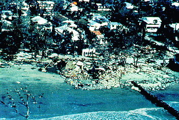
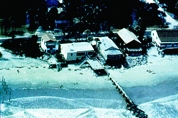
Hurricane Hugo was a Category 4 storm which struck the coast of South Carolina during 21/22 September, 1989. It caused $7 billion worth of damage, second only to Hurricane Andrew. These homes in Folly Beach, SC, were demolished by the hurricane's storm surge. (Image courtesy of NOAA/National Weather Service)
( adapted from http://windows.ivv.nasa.gov/earth/Atmosphere/hurricane/surge_inset.html Copyright 1995, 1996, 1997, 1998 The Regents of the University of Michigan )
Hypothesis:
We can visualize the effects of storm surge using local lake shores as our model sea coast.Exercise:
1. Using maps of Lake Harwinton and Lake Garda, map the extent of a 5, 10, and 20 ft storm surge.
2. Draw a cross section through each lake showing the reach of these flood levels.
3. Describe the effects of these flood levels on the shorelines.
Billion Dollar U.S. Weather Disasters at http:// www.ncdc.noaa.gov/ oa/ reports/ billionz.html
Senators Slam White House Over Storm Alert at http:// hosted.ap.org/ dynamic/ stories/ K/ KATRINA_LEVEES?SITE=VTBAR&SECTION=HOME&TEMPLATE=DEFAULT