


Beechers Island Battleground, Colorado

When I last visited the site of Beechers Island Battleground in 1992, it was
nothing but a remote, pleasantly quiet wayside. There was nothing "official"
there but this monument and some roadside tables. I think the large building
in the background is an old Grange Hall or something; it's not part of the battle
site.
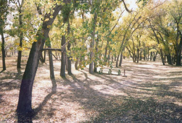
The neatest things, I thought, were the water and the trees. The Arikaree River
flows softly past the site, and it's lined with a few old cottonwoods. I was
there in the fall, and the trees were gently shedding yellow leaves, like big
snowflakes in a spring storm. The air was dry, the sky was deep blue, and the
afternoon sun was sparkling through the leaves - everything had a golden light
to it.

The stream was about an inch deep and ten feet wide. But, considering that
its source is near Limon, I can't imagine that it ever flows much more than
that - except maybe during heavy rains. It really makes me curious about what
the stream must've been like when this battle site was given its name. I mean,
did it really flow with enough volume that it braided and formed multiple channels
and islands? From what I recall, the Indians had a small band of whites trapped
on an "island" for several days before reinforcements arrived. But the river
we see today is not big enough to be a barrier of any kind. In answer to that
question, Larry Haskell wrote to me with this explanation:
"My father grew up on a farm, which my grandfather homesteaded in 1905.
It was on the Arikaree River east of Vernon, which is upstream from the site
of Beecher Island. My uncle (who lived in this area all his life) said he
watched the changes over the years, and had a reasonable theory about what
happened to the rivers. Land in this area is good for dryland farming (which
means crops are grown without any water other than the meager annual rainfall).
It worked well for at least two generations. But then there came a generation
that largely did not stay on the farm - when their fathers retired or died,
their children did not want the farms for whatever reason. So many of the
farms were bought up by corporations. Of course they were in it to make as
much money as they could, and to avoid a bad year due to low rainfall, they
started drilling wells and irrigating the farms. The long-term effect of this
is that the water table in the area was lowered, and several streams dried
up or went underground. I think this is what has happened to the Arikaree
River. It used to flow steadily. In fact, there was a flood along it that
washed Beecher Island away. It also washed the monument downstream several
miles."
Page last updated 24 August 2005.
|