


Black Mesa - highest point in Oklahoma
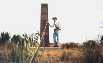
This is the highest point in Oklahoma. It's in the panhandle, just
inside the state line, where Black Mesa winds into the state from New
Mexico and Colorado. It's a mildly strenuous hike to the monument -
about an hour and twenty minutes from the parking area, as I recall.
But it was well worth it, for the solitude and for the beautiful
vistas of the mesa country. Don't go if you're loathe to
mammoth-sized grasshoppers and alien bugs that look like little
armored spacecraft. When I was up there (October '95), I could pick
out several landmarks way off in the distance: Rabbit Ear Mountain to
the south in New Mexico, Sierra Grande to the west in New Mexico, and
Tecolote Mesa to the north in Colorado. Bonus: there's a petrified
dinosaur footprint track not far down the road from the trailhead
parking area.
Cary Todd is a big fan of this part of Oklahoma. If you're
interested in learning more about Cimarron County, click
here to visit his page.
Page last updated 26 August 2000.
|