
SPRING 1999

Effects of Altitude and Latitude; Transformation of Energy; Remote Sensing Imaging
Brekenridge, Colorado -- 28o Celsius -- 7500 ft above sea water
We all have noticed how many mountains are snow capped but at the base of the mountain there is plant life and trees. So why are there not trees and plants at the top of the mountain? Altitude!!! Higher altitudes have colder temperatures, which are not conducive to plant or tree growth. The highest altitude that trees grow on a mountain is sometimes referred to as the tree line.
Mountain range in Colorado, latitude 42o
The average temperature of the earth is 288oKelvin (K). At the end of last lecture you were presented with an equation for energy/radiation:
E=gT4
Where:
E = energy/radiation given in wavelength notation
Using the equation above it was determined that energy emitting from the core of the earth is infrared radiation.
Temperature of the sun is 10,500oF or 6000oK
Using the equation above scientists have calculated that the majority of the sun’s radiation is in the form of visible light of the electromagnetic spectrum.
When visible light from the sun reaches the earth some absorption occurs at the surface and the remaining radiation is redirected back into the atmosphere. A transformation of energy occurs in which the visible light of the sun is transformed into infrared energy. Visible light has more energy than infrared energy and this loss of energy is a result of the absorption of energy at the earth’s surface. As we know infrared energy is better known as heat.
How do we as humans get energy? From food. Where do plants and animals get their energy? Sunlight. Sunlight for photosynthesis and plant growth leads to its consumption by animals. It’s a cycle that requires the sun’s visible light to drive the cycle. Other forms of energy that bombards the earth are ultraviolet light, gamma rays, etc. Radiation becomes significant when considering the climate and weather of the earth.
Simple observations:
When sunlight hits the ocean water at sunrise or at sunset there is a glare on the water due to the angle at which the sun’s rays are reflected off the water. When the sun’s position in the sky is closer to being to perpendicular to the surface of the water there is much less glare off the water making the water appear dark. The reason that the water appears darker is that there is less reflection and more penetration by visible light into the water. The result by the increased penetration is more absorption by the water of visible light that will then be transformed into heat.
Have you ever noticed that the sand gets really hot in the summer? If the sand feels hot to your feet then the sand must be warmer than your skin, which is typically 92 oF. The temperature of the sand is 115o-120oF. Does the ocean get to be 115o-120oF? No. The reason is about the different absorption properties of sand and water. It is more difficult for visible light to penetrate sand than water. Therefore the surface of the sand retains the same amount of energy that is distributed more thoroughly in water. Differential heating and cooling on the surface of the earth makes a difference in the surrounding climate and weather.
One winter day the following temperatures were recorded:
In class we saw digital satellite maps. Satellites that take these digital images utilize optics that detect visual light or infrared radiation. You can imagine how infrared optics would be crucial for creating satellite images in regions of the earth where the sun is not shining. The satellites that are responsible for remote sensing imaging are 22,000 miles above the surface of the earth. These satellites relay important information to us about cloud formation, land features, and the temperatures of water, land, and air. Satellites are used to predict and follow the effects of El Nino and La Nina by comparing hot spots and cold spots in the oceans. All of the information provided by remote sensing imaging will contribute to the compilation of data that will be used to extensively record and predict the weather of our planet.
In the last lecture we investigated the different latitudinal effects on climate. As we know the hottest temperatures reached on Earth are in regions closer to the equator. As one goes away from the equator towards the poles the temperature decreases. The result is that at different latitudes there are different climates and environments. There is another factor we must take into account when determining the climate of a region and that is altitude. Altitude is a much stronger force than latitude over short distances.
Example of the effects of altitude versus latitude:
Denver, Colorado -- 52o Celsius -- 5000 ft above sea water
Cities are only 70 miles away so latitudinal or longitudinal forces are minimal.
Temperatures for both cities were recorded on the same day.
What is responsible for the temperature difference for these two cities only 70 miles away from each other? The difference is afforded to the altitudes of the individual cities. Temperature decreases as altitude increases in the troposphere. At higher altitudes in the atmosphere where ozone and other gaseous molecules are undergoing photochemical reactions the temperature will increase.
Example of the effects of altitude and latitude:
Mountain range in Alaska, latitude 62o
Tree line is higher in Colorado than in Alaska. The different altitudes of the mountain have no bearing on why the tree lines are different. Why different tree lines? Is the climate in Alaska the same as in Colorado? Nope! Alaska’s weather is much colder and drier than Colorado’s so we can expect that at the same height on both mountains there will be colder temperatures. Another way of thinking about is to imagine that there is a standard decrease in temperature per feet so this is the constant variable between the two mountain ranges. So even at the same altitude Alaska’s mountains will be colder than Colorado’s because the initial temperature will be much less in Alaska. Why is the initial temperature colder in Alaska than in Colorado? There is a 20odifference in latitude between the two cities.
g = constant
T4 = temperature
Transformation of Energy
Example of differential heating and cooling:
Dulles Airport -3oF
Reagan National Airport 27oF
20 miles only separate the two airports and there are several reasons to explain why over a short distance there is such a difference in temperature. The key is differential heating and cooling of the surrounding environment. First point, the Potomac River runs along National Airport. In the winter the river is warmer than the ground. Dulles is not surrounded by water therefore National Airport will receive heat from the river. Second point, National airport is in close proximity to the city, which is sometimes referred to as an "urban heat island". Concrete, homes, buildings, etc. give off heat that contributes to the surrounding temperature. Dulles is airport is more secluded from the city than National. Dulles airport sits at the bottom of a valley. Cold air sinks to the bottom (which explains why our feet are sometimes are the first thing to become cold). National received no snow whereas Dulles received snow. Snow is radiator of energy. When sunlight bombards snow it is quickly released yet the middle of a snow pile will be remain warm (i.e. that is why the inside of an igloo can be 20 degrees warmer than the inside). The surface of snow remains very cold. If snow remains on the ground more snow is likely to come if another cold front comes through the same area. As one can see the geology of the location plays an important role in that location’s climate and weather.
Remote Sensing Imaging
Fossils Fuels: Black Gold or Sunshine in a Rock
The following percentages give us the breakdown of types of fuels used:
Fossil fuels are a major source of air pollution. The transfer of electricity from site to site is one large part of this. The sulfur found in coal and oil is the major concern here. Fuels are classified by the amounts of sulfur they contain:
These products can be "fingerprinted" and identified as to where they came from based on the amounts of sulfur they contain.
The biggest factor in where fuels are depends on how easily it can be put onto the market.
Petroleum production comes from the remains of marine plant and animal fossils. (One organism [phytoplankton] dies, decays, and becomes a drop of oil!) Current big producers of petroleum are the OPEC members, who control more than 50% of global petroleum.
However, new players are coming onto the scene and will be gaining in importance:
1. East Soviet block of the former USSR
Transportation of the product is important in its use and in world economies. Because of this, we sell Alaska oil to Russia, because it is easier to get it there than to the mainland US. (Also --- the Trans Alaska Pipeline System (TAPS) must go through permafrost to be moved, and there is a major environmental impact with this.) Therefore, the eastern US gets most of its oil from the middle east and Africa. There are 5 major oil companies in the world, and 3 major oil lines. Every country wants the oil line to pass through their area, because of its economic value.
Petroleum is used to make more than 260 products, such as:
More than 70% of the fuels we use are fossil fuels, which are non-renewable fuels. Why is this? Where do they come from?Petroleum -- 39.7%
Natural gas -- 23.1%
Coal --27.2 %
Nuclear -- 7.0%
Hydropower -- 2.5%
Geothermal and wind -- 0.5%
Where Fossil Fuels Are Found
Petroleum
2. West coast of Africa
3. East and South China Sea

USES OF PETROLEUM
Coal
Coal is formed from the stratification of the remains of plants in swamps and marshes, in areas above sea level. These plants lived in the tropical areas on Earth appx. 200 million years ago. The processes used to create coal no longer exist. The only two swamps that still exist (Okeefenokee and the Everglades) that could form coal show no evidence of processing decaying plants in this way.
As the sources of petroleum are depleted, more and more coal will be used as an energy source. (Coal had been a major source in the 19th century, until petroleum became the primary energy source.) Coal is still used as an important source of energy in electricity production. The US has coal reserves that should last for hundreds of years. However, it is difficult to recover coal, as surface mining decimates the land, turning it into a wasteland, and underground mining is quite hazardous to human health and life.
Coal is formed by the "squishing" of biomass, e.g., plants. When this pressure is applied, (plants on top of plants on top of plants, etc.) H2O and gas are released. The more of these substances that are released, the harder the coal becomes. A classification system for coal is based on this:
Problem: although we can apply pressure to biomasses, we cannot do it like nature. Therefore, cannot duplicate process in the lab and make coal.
The transport of coal remains a big problem. Most coal in the world is found in the US, Wales, Poland, the Alsace-Loraine area of France and China. Trains are the main mode of transport, although pipelines are being investigated. (Slurries are made of the product, and passed into pipelines.)
Interesting fact: There is quite a bit of coal at the bottom of the Atlantic Ocean, due to the sinking of boats during WW1.
Pollution from Fossil Fuels
The burning of fossil fuels contributes to several forms of pollution: an increase in the amounts of CO2 in the atmosphere; urban air pollution; and acid rain.
1. The amount of CO2 in the atmosphere has been increasing over the last 150 years. When this gas increases in the air, it absorbs radiated heat from the Earth, trapping it and re-radiating it downward towards the Earth. As we can see from the following chart, the total parts per million (ppm) of CO2 have been increasing, with seasonal fluctuations noted.
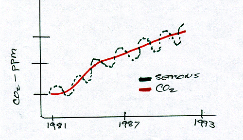
MAGIC CURVE
Increases of CO2 with Seasonal Variations
2. Urban air pollution comes from several sources:
To counteract some of the sources, different procedures have been put into effect:
Oil spills from tankers in the oceans are another form of pollution; however, there is more of pollution from petroleum from the run-offs from roads, parking lots, etc., in the cities. Every time it rains, there is more of a petroleum "spill" than from the Valdez spill in Alaska!
An upcoming major source of air pollution from fossil fuels will come from China in the years to come, as they are just now starting to increase the umber of automobiles. Also, China has coal sources that have not been mined yet.
Both coal and petroleum have contributed to the cultures of our history. Many books, songs and movies have been written with the "glamour" of coal or petroleum backgrounds and politics.
Internet Sites
The following sites are very important sources for more information about coal and petroleum:
http://energy.usgs.gov
http://energy.er.usgs.gov/products/open file/OF 96-92/map.htm
(Study map)
http://energy.er.usgs.gov/products/papers/WMC/17/index.htm
(MUST READ ARTICLE!!!!)
 Click here to go to the Spring 1999 Page!