SOUTH AND SOUTHWEST COAST TOUR

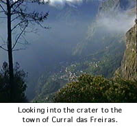
Leaving Funchal and heading northwest, we travel to the
small village of Curral das Freiras. Curral das Freiras is
located in the bowl of a centuries old crater. At one time access
to this village was very difficult as there were no roads down
into the crater. The name means "nuns' shelter," for it was here
that nuns from the city of Funchal found safety when the island
was being attacked by pirates.
Traveling west of Funchal, the first town is Câmara de
Lobos, or "seals' house." When the island was discovered the area
was home to a large number of seals. The town is known as a
fishing village.
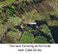
Not too far west of Câmara de Lobos is Cabo Girăo. This is the second highest cliff in the world. From the top it is a straight (and very high) drop to the ocean. Standing at the top, you have a clear view of the terrace farming seen throughout the island as farmers make use of virtually every available piece of land.
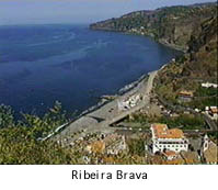
As the road travels along the coastline and then up and
down the sides of mountains, the traveler finally arrives at the
town of Ribeira Brava. The town is located at the mouth of the
Ribeira Brava, or "Wild River."
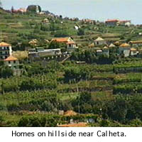
By the time you reach Calheta on the southwest end of the
island, in addition to continued traveling up and down the sides
of mountains, you have also driven through tunnels dug through
mountains. Here, as well as on the north coast, cars get a quick
car wash as they enter and exit the tunnels from the rain water
cascading down from the mountain tops.
The north side of the island will bring cars along narrow
roads perched on the sides of mountains. The low or (in some
locations) almost non-existent guard rails provide driver and
rider with an invigorating experience.