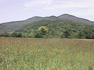
Eastatoe Valley
DIRECTIONS to WEST enterance: Leave Pickens on West Main St, also known as US 183 or Wahalla Highway, just as the road narrows to two lanes turn right onto Shady Groove Rd, there will be a convenience store and service station on the right at the corner. Drive out Shady Grove Rd about 6 1/2 miles, some of the roads you will pass are Morris, Red Hill, Meece Mill or Concord Church depending on which side of road you'll looking, Reese Mill, Mt Bethel, Old Durham Store and a couple more. Turn right onto Little Eastatoe Road, it'll be at a curve at the bottom of a hill. If you miss the turn you'll end up in Shady Groove at SC 133, turn around and go back a mile. Drive up Little Eastatoe Road to SC 11 also know as Scenic Highway 11. Go across SC 11 onto Roy F Jones Memorial Hwy, this will take you down and across Eastatoe Creek up and over Dug Mtn into Eastatoe Valley. You'll go under some powerline towers on Dug Mtn and there's a nice view of the mountains from there. Turn left onto Cleo Chapman Hwy and go till the road ends in the lake at the west end.
Along about the mid 1960's one of Dad's cousin's talked about "something big is going on, lots of people been asking me about Keowee and Jocassee." By the end of decade Duke Power had bought up all the Keowee and Jocassee river basins and built the lakes. It was a major loss of river and gorges in the foothills and mountains. But the lakes and hills and mountains go together now, it's nice too, except for the history that's on lake bottom now.
The west end of Eastatoe Valley is being lost too now, one of them rich people sub-divisions has moved in, it'll never be the same wooded valley again. The shaded road has been opened to hot summer sun and there's fancy stone gates at the side roads where there use to no roads at all.
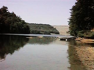
Anyway, from where the road ends in the lake back up to new SC 11 use to be Old SC 11 highway. Chapman's covered bridge use to be about half way to the Jocassee dam. It was moved to a cove below Keowee State Park on Senenic Hwy 11 but some stupid kids started a fire on it and now it's gone too. There's 300 feet of water behind that dam; kinda spooky thinking about it. Dam's got a leak in it too, it's up near the top on the left but's it's a clean leak and been there all along.
The dirt road at the west end of Eastatoe leads off up into the Horsepasture, it's a jeep and four wheel drive type road. Maybe it's a walking road now; it was in really bad shape last time I went up it (mid to late 1980s). I was in my jeep or truck at the time easing on down a hill, got to the bottom where it curved and crossed an old wooden bridge. The bridge looked like it would fall in, full of missing boards and what's left didnt look good either. I was going too fast to stop so I prayed and hope for the best. It held together.
The dirt road passes by the top of the cliffs next to Jocassee dam, you can see these cliffs from Devil's Fork State Park over in Oconee county. There is (was?) a path from the road down to the bottom of the cliffs, it was a popular hangout for the kids. They would swim over to the cliffs, climb up them about 20 or 30 feet, then dive in.
Ok, whoaa, that was leading out of Eastatoe Valley into Jocassee, Horsepasture, Laural Valley which is another tour altogether. Back to the Eastatoe Valley tour.
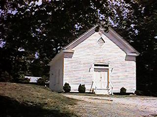
Thomas McKinney was one of the earlier settlers in this valley, 1800's early, not the earliest. McKinney's Chapel gets its name from him, he was Methodist. The McKinney name also appears on Mills 1825 Atlas of the area, McKinney Ford and McKinney Creek. He was also one of the mail carriers and would travel down to Pickens CourtHouse (present day Pickens) for the mail and bring it back for the folks that lived in Eastatoe Valley.
Historical Marker
KEOWEE COURIER April 1878: [Thomas McKinney was caught up in all the bad Revenuers bad conduct early and there were a couple of exchanges in the newspapers between him and one of the officials.]
Mr. E. G. Hoffman, Special Deputy Collector, in an article in the Charleston NEWS and COURIER, defends the conduct of the revenue official in Pickens and Oconee Counties. He states that the information as to my treatment by these worthies "is equally false," with the statemetn made by Mr Neal of Pickens, as to their conduct at his house. Fearing that Mr. Hoffman's memory is short, I will again publish for his benefiet exactly what did take place. On the 20th day of March, 1878, while at work in my farm in Pickens County, twenty or more mounted men, many of them under the influence of whiskey, charged upon me with their guns and pistols cooked. I was arrested and coarsely cursed by one Aaron Thomas, a member of the gang. I was place din custody and carred to Walhalla on the 21st of the same month, a distance of twenty miles, and there released, to appear before the United States Commissioner in Pickens. No warrant or authority for this arest was shown to me until we arrived at Walhalla. The warrant purported to have been issued by Mr Thornley, of Pickens; but he has since assured me that he did not make the warrant. It must, therefore, have been a forgery. This crowd of miscellaneous humanit, ast the time of my arrest, entered the dwelling of my mother, some armed and some at the door with their pistols cocked. She is nearly eighty years of age and very feeble. They searched her house and attempted to open the trunks and boxes. Their authority was demanded, but none was prodcued. Gary turned up my mother's bed with his gun and looked vulgarly about it. My mother's house was searched up stairs and down stairs. One of the crowd had a jug of whiskey around his neck, and nearly all of them were under the influence of liquor. A man called by the crowd "Hoffman," was present. One of my neighbors, Phhillip Chapman, was arrested at the same time, carried to Walhalla, and there released. There was no warrant against him. Thomas McKinney, Postmaster at Eastatoe, SC.
*---*---*---*---*---*---*---*---*---*
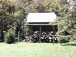
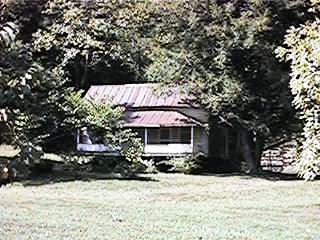
There's been settlers, or at least traders, in Eastatoe for more than 200 years even though it was one of the last of the Lower Hills Cherokee valleys in the upstate of South Carolina. Maps from 1740 through 1790 show the Big Eastatoe Creek and the Cherokee town of Eastatoe, they were called towns more than villages with wooden type houses for the Summer and low half above ground half below earth covered for Winter. There's still one log cabin left that would pass for a trader's cabin; most of the other older homesteads are from the late 1800's early 1900's, if they're that old.
I've always felt the Traders and Pioneer folks got along together with the Cherokee, least more so individually. It was always white man's government that stirred up the troubles.
Along about 1760's there was a heap of trouble down at the Cherokee Keowee Town and Fort Prince George area (under water now, just northwest of Mile Creek County Park). Two or three of the British soldiers from the fort got drunk and went across the river to the Indian town and ill treated some of the women there. The Indians made complaints about it and wanted justice and punishment for the guilty soliders. Anyway, one thing lead to another and before it was all over, the soliders massacred Indian prisoners, the Indians seieged the fort and killed all the soliders. From Pearl McFall's book and Ramsaey's History: "By April 1760 some British Colonel lead expedition from Charleston "with orders to strike a sudden blow for the relief." They camped one night at a place near Twelve Mile River and then proceeded the next morning to Eastatoe Village which they found nearly abandoned. The town was located where the streams of Big and Little Eastatoe come together and had about two hundred dwellings. It was well provided with foods and game and fruit trees. They reduced it to ashes and then proceeded to Keowee Town and Kulsage which shared the same fate."
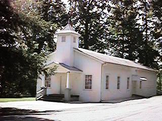
Over the decades and centurys now, from Colonial American to the "Trail of Tears" in 1835 and the rest of the 1800's the valley changed into homesteads along the McKinney - Chapman road. There was reports of a gold mine in the valley at one time, that may be true or not, unless you count riverside farmland and hilllife as gold. Or was it moonshining part of the time? It seems the Methodist had the West end of the valley while the East end belonged to the Baptist. There's a Baptist church next to the river with an outdoor shelter for church gatherings. There's a conifer tree of some kind, Eastern Hemlock or a Spruce in front of the church, it looks to be a couple hundred years old itself.
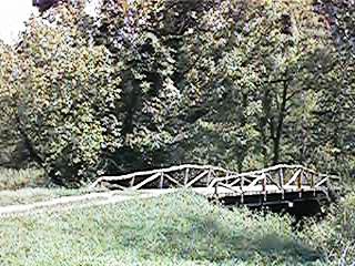
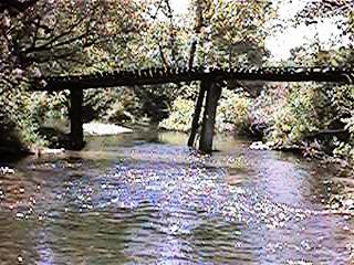
The farmers built wooden bridges over the river in order to farm both sides of the valley. The Eastern half is were most of the farming was done, the land was flatter and bottom lands wide. The Eastatoe Cherokees, at one time or another, probably had their town there too. The area would have been more wooded then than now, it was the settlers who cleared more and more of the valley floor. Perhaps a natural meadow where the smaller branches and streams fed into the Big Eastatoe. One thing for sure, the Cherokee knew about the falls.
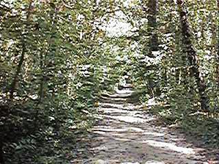
There's this side road, Eastatoe Community Road, which leads off northward from the Chapman Road. Drive up it about a mile and turn right onto Water Falls road. After you cross the bridge, and yes it will hold up a car, follow the dirt road by the homes. This is private property back in here so mind your manners and be respectful of it. The road gets narrower and narrower but keep on going. There's a left bend in the road and it continues on up into the woods. If you meet another car, one of you is going have to backup and make room to pass. There's a loopback into a wide place where you can park. Follow the foot trail beside Reedy Cove Creek up to the falls.
As you walk up the trail, check out the ferns, trees, an old cabin site, laurel and all the other nature things. It's the same what the Cherokee have been checking out too for centurys, along with the traders, pioneers, settlers and homesteaders. There's a few flat, clear places where some of the young folk campout beside the creek. As the trail narrows and follows along the bank beside the creek, it is exactly where the Cherokee walked too. You'll hear the falls before you see them, along with the sound of water over rocks in the creek.
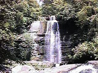
The Falls, they've been called by many names, Eastatoe Falls, Reedy Cove Falls, Twin Falls, and whatever names the Cherokee used. For sure it was one of the "power places" where they communed with God's nature. The same as we do today. The Boy Scout troops from Pickens have camped here. The hill and valley folk of the 1900's came here along with those town folks from Pickens. Moonshiners, revenuers looking for moonshiners, homestead and settlers and traders came here. Yet it's just a waterfalls in the back corner of Eastatoe Valley. Not high, not wide, no vista from the top, just a valley water falls.
In the 1920's and 1930's the Appalician Lumber Company, part of the Singer Company that made the sewing machines down in Pickens, built a logging railroad. It started in Pickens where the lumber mill is behind Town and Country Plaza. It wound it's way along the side of hills and mountain passes up into what is/was the Horsepasture above Lake Jocassee. At the top of the falls is part of the old railroad bed with some of the railing. There use to be a rail in the creek below the falls but it is gone now (Sept 1998).
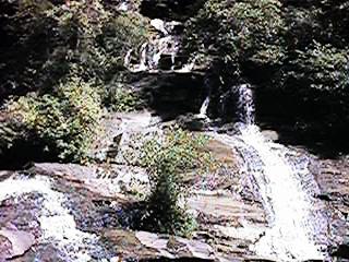
Above the falls Reedy Cove Creek leads up to Royal Ambassadors Camp, a Baptist Church camp for youth during the Summer. It's on US 178 on the way to Rocky Bottom. Follow the creek on up into the mountains and you get to Reedy Cove which is just before you get to the RA Camp on US 178.
Below the falls Reedy Cove Creek runs into Big Eastatoe Creek. Follow Eastatoe upstream and you pass through Laural Valley above Rocky Bottom and then beside US 178 on up into North Carolina to Eastatoe Gap.
Follow downstream through the valley, pass McKinney Mtn and into the Keowee near the north part of Keowee State Park. And the Keowee lead to Fort Prince George and Cherokee Keowee Town about 5 miles downstream.
Such was how the Cherokee thought of places, where the streams, creeks and rivers lead. Where the valleys, mountains, water falls, villages and towns were. Trails alongside water, trails snaking out and back up and over a mountain. Time measured in fractions of a day or number of days walk to get from one place to another.
They came here, to these falls, to escape the heat of long Summer days. The young bucks and maidens came here too on Summer evenings to sit in the mist of the falls, in the midst of love, in communion with Nature.
Historical Marker
It is said among our people there was once a maiden of seventeen summers, a beautiful daughter of a lower hills village chief. She was called Jocassee.
The young bucks of her village sought her attention with gifts from the forest. Some gave beads made from the green, blue and yellows stones; others gave wild flowers and ferns. They all showed off their skills at in the games they played. Chunga to show their spear throwing accuracy, lacrosse to show thier running endurance, bows and arrows and blow darts to show shooting ability. They gave gifts to the chief too, arrowheads, spearsheads, animals skins and other useful items from the forest. Gifts along with words of interest in Jocassee.
There was one among them, Loud Crow, who wanted her more than the others. He always made extra effort to out do the others in the games. He give more gifts to the chief along with whispers of how good he was at hunting and providing for future mate.
Jocassee gave them all little notice, just a friendly interest in the braves of her village. She would gossip and giggle with the other young women as they watched the braves. Talk of who was best at chunga, who best with bow and arrow, who ran the fastest and longest. And who among her friends liked who among the braves.
But she thought of another in a neighboring valley. He was a brave of nineteen summers, handsome features of a youth changing to a young man. He quietly hunted and ran through the forest, swam in the rivers, climbed the hills and mountain ridges. Exercise that showed through his form. He was called White Water because of the days he spent at the two high waterfalls on Two Falls River.
They, Jocassee and White Water, would meet at different places in the lower hills, a bend in Keowee River, rapids on Whitewater River, high rocks and cliffs above the gorges. And the Twin Falls over in Eastatoe valley too.
During the time when the green returned to the trees and meadows, and plants came back to life, a wolf pack came into the lower hills. They hunted for the small animals and fawns, game that the villages needed. The chiefs of the Keowee, Eastatoe, Secona, Toxaway held council and agreed to a hunt for the wolf pack. The braves were gathered, among them were White Water and Loud Crow. Each group was given an area to search and track for the wolves. White Water in one, Loud Crow in another.
A few days passed and the hunt for the wolf pack was still going on. White Water was out away from his group of braves, following a set of tracks up a stream between two ridges. Loud Crow was out hunting alone too, he was following one of the ridge's crest. He moved quietly ahead and down the side to where the stream came out of the mountain. He hid among the laural bushes.
White Water was closely studing the tracks as he went along, making sure he didnt miss a turn if the wolf left the stream. He heard a rustle of leaves and looked up toward the sound, thinking the wolf might be near. There was the swoosh of feathers through the air, then the sting of an arrow in his chest. The aim was sure, his heart was pierced.
Loud Crow took the wolf paws, jaws and tuffs of fur he had saved from an earlier hunt. He used the jaws and paw claws to make marks on White Water as if the wolves had killed him. He used the paws to make tracks around the stream and up the ridge. He left the tuffs of fur on twigs and branches of bushes and tree trunks, then clenched White Water's fists around some. He cleaned the jaws and arrow in the stream and buried the paws beneath a rock in the stream. When all was ready, he ran to the top of the ridge and yelled for the others to come.
Jocassee was cleaning fish by the river in the bottom land below where Two High Falls river and Bear Creek joined. News of White Water's death followed the water courses down the Eastatoe and up the Keowee. Loud Crow made sure he was the first to reach Jocassee. He stood above her and held out his hand with White Water's long topknot of hair which he had taken. "White Water is dead, you will be mine now," he said.
Jocassee looked at the long lock of hair and then at Loud Crow. On his face and in his eyes she saw the truth, it was no wolf animal that killed White Water.
She left the fish where they laid and went to where the canoes were tied. She got in one and began to paddle over to the Oconee's land. When half way across, where the river was swift and deep, she tipped the canoe and fell out, making no effort to swim. Beneath the waters she sank to join her lover where Summer never ends. The two villages buried lovers on the point of land were the river and creek ran together. As the generations passed the story of Jocassee and White Water became place names to carry on their memory. Two High Falls river became Whitewater River since that was where he like to roam. Bear Creek became Jocassee River and the gorge where her village was later called Jocassee too, as well as the village.
*---*---*---*---*---*---*---*---*---*
It's always difficult to know what the true legends, lore and stories were. There are two variations of the story above and both of them are recent in telling, mid 1900's which in turn are probably passed dowm from the 1800's.
The common essential elements are there though: the daugther of a chief in love with a brave from another village (some say rival tribe), the other suiter who's the chief's favored brave for his daughter (some say it was her brother who didnt like Jocassee's lover), the wolf hunt (some say it was a contest, the brave who killed the most won Jocassee), the killing which includes a scalping (some say it was a beheading), the scene with Jocassee at the the river and her canoe trip and drowning. The rest of the above ledgend is my imagination of what happened.
Jocassee Gorge and Whitewater River are genuine place names now. The 1823 Mill's Atlas shows a Jocassee River which has become known as Thompson River now. The earliest maps, 1600's and 1700's, of Lower Hills Cherokee villages dont show a Jocassee town along with Eastatoe and Keowee. So the Jocassee name was after the European's came to the area. I've search several websites for Cherokee Lore and Stories but found none about Jocassee. Jocassee usually brings up references to the gorge, water basin, dam and lake.
© jwhughes 1998