Whitewater Falls
DIRECTIONS: There's three ways to get from here to there. Well, there's more than that depending on what you want to see along the way. I guess one could do a 25,000 mile world tour to get 55 miles up the road. So here's one way.
Path #1. From Main Street Pickens drive about 12 miles West on US 183, Wahalla Highway, to SC 130 which is a mile or so pass the bridge over Keowee River. Along this part of the path you'll go over Twelve Mile River just a couple miles west of town. On the left, across the road from a lumber mill, was the old Murphree cabin which was built in 1780's. The cabin was moved to the Hagood Mill site in 1999. After you cross Twelve Mile and also on the left are a couple of flea markets, they're open on Wednesday mornings, so if you're traveling that day watch out for all the traffic.
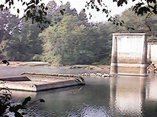
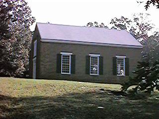
The rest of this part is a ride through the country, passing through the Westside flats, up and down hills, by Six Mile mountain (near SC 137 junction), across a ridge line and on to where Old Pickens was next to the Keowee River. There's an old, dirt road turn just before the Keowee River Bridge, it's the older roadway and doesn't go far. But you can see the old bridge piers there and across the river is the hill where Old Pickens was. Just after crossing the river there's another dirt road turn off, it leads up the hill to the Old Presbyterian Church and that's pretty much is what left of Old Pickens.
Turn right onto SC 130 and US 183, you'll drive across another bridge, it's part of the Oconee Nuclear station which is just a little ways on up the road and on the right. That's an interesting place to stop too. Duke Power has a visitor's center there along with some picnic areas and a nice view of this part of Lake Keowee. You'll want to follow SC 130 toward Salem which means you take the right fork in the road where it parts company with US 183. Salem is about 10 miles up this stretch of road, it's still a small town community. Stop for a short visit and then drive on up SC 130 to Scenic Highway 11, that's another 3 miles or so.
At Highway 11 you can make a quick side trip, or a longer one. West on SC 11, about 2 miles, is one of them Historical Markers. It's where the old Cherokee Trail was that lead between Fort Prince George on the Keowee River to Fort Loundon on the Tennesse River. Just past the marker you can turn left and drive down to Three River Country Store. That's one of the real country store places. It's also where one of the Stage Coach stops was a long time ago. For the longer side trip ride on out SC 11 to the Daughters of American Revolution Tamassee school, it's enterance is marked with stone gates. General Andrew Pickens retired to this place, it got too crowded for him back in Pickensville south of Easley. Drive back to the SC 130 and SC 11 intersection.
Follow SC 130 for 10 miles up into North Carolina, it's really uphill all the way now. There's a look-off point on a road that connects with SC 107, it's just a couple or three miles if you want to go to it, and the weather is clear. On a good, haze free day you can see Lake Jocassee, Pinnicle and Table Rock and Glassy Mountains, and pretty much all that is Pickens County. Drive back down to SC 130 and go on up hill into North Carolina. Whitewater Falls is on the right off of NC 281. You'll drive down into the car park, it's relatively new now and not the grassy area it use to be. It's even got new fancy restroom facilites.
The first walking is along part of an old roadway, actually the short ride down into the car park is part of the old roadway too. But anyway, this first part is a paved trail now, it leads up to the overlook for viewing the falls. There's a split rail fence there. You can see both tiers of falls, together they make the Upper Falls, the Lower Falls are a couple of miles down stream. You can see down into the gorge too, parts of the river among the brush and trees. There's a trail to the right of the fence, it use to be just a step, rock to root stepping path, but the NC Park Service put in some stairs recently. There's another overlook about 100 yards down, it looks the falls more squarely and at their height. The trail by the way is part of the Foothills trail, the same one that crosses over Sassifrass Mountain above Rocky Bottom. It's a steep and easy walk down to the river and the foot bridge across it. It's still steep when you climb back up too, so remember that if you go down there. There's a bit of nice woods, ferns and such, along the trail as it follows the river. After that it just becomes a trail through the woods.
Back at the top overlook at the other end of the fence, the trail follows the old roadway over to the top of the falls. It's narrow and cut into the side of the ridge, cliffs on the upper side, another steep ridge fall on the downer side. Believe it or not, cars use to travel this way. It's all grown over with trees and brush now, except for the foot path. The trail eventually makes a right turn and leads to what use to be another car park, a long time ago. It use to be fairly clear but it's grown up in the middle with small trees now. Somewhere about here you'll see a sign, "WARNING: Several people have died while climbing around the top of the falls and off the trail. ...." Read it and heed it; then be very, very careful when you do it anyway.

There's probably a campfire ring near some felled tree trunks where someone's camped out. There's also two paths hidden among the brush. The one behind the felled tree trunks goes to a place where you can look down onto the crest of the falls. You can also climb down to the very top from there too, but it really is climbing down, hanging onto saplings, roots and rocks. The other hidden path is just a few yards around from the first. It's the open gap in the brush. That's the easier way to get down to the falls. It's probably muddy and slick along here, that's because there's never much sun on it and the water just comes out of the ground.
Down at the bottom there's an overhanging boulder, a small, shallow cave of sorts. It's the same boulder the other path leads to at the top. There's also probably the remains of another campfire too back up in the cave looking part. There's also some writings on the granite, the usual initials and dates, one looks like it was put there in 1921. There's another boulder under the bigger boulder and just enough room to crawl up onto it and sit. The view from there is nice, especially during the Summer storms. Just sit there all bundled up in blankets and towels, listen to the thunder roll up the gorge, watch the trees sway in the wind blown rain. Probably along with a bit of praying that the lighten doesn't strike the big boulder and bring it down on top of you. [Been there, done that.]
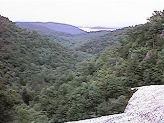
With a bit more of climbing down you can walk around the flat rock that makes up the crest of the falls. There's usually a couple of places to look over and down the first tier and then on down through the gorge. The lake is Jocassee, the left ridge is Long Spur and the right is Grassy Knob. From the right position you can see the split rail fence overlook as well as the other one that more eye level and straight across the open space. Sometimes, if you spend enough time there, several afternoons and early evenings, you'll get to see a hawk of falcon fly around in the open space. Whitewater River sluices through a trough about 5 feet wide before it spreads out some to go over the crest. When it's been dry for a long time it's easy to walk around along the edge, there's even a good sitting place at the edge. When it's been raining though, the rocks are covered and that sluice runs really fast.
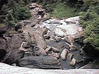
Along side the right of the falls there use to be a trail down to the lower tier and from there on down to the bottom. It's another one of them un-official trails. There was a really bad ice storm a few years ago and several trees fell. That made it into a hard climb, it wasn't that easy to start with. There's a pool at the bottom where this side trail comes out. That's where all the adventurous young people go. Most usually go down to the foot bridge and climb back upstream to get to it. It's cool down there even on the hottest Summer days. But climbing back out in the humidity and heat wears that off fast enough. [Been there, done that too.]
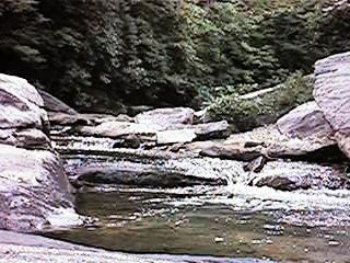
Back upstream a few hundred yards is another camping area, un-offical one that is, next to some rapids and sliding rocks. The trail passes by them before leading off on up Grassy Knob and over to Oconee State Park. The old roadway crossed over the river above the camping area too, the new bridge is another hundreds yards up stream. There's several off-trail trails, those kind where people wander about on their own along both sides of the river. The mountain laural shrubs are nice and there's a few really old trees there too. There's another overhanging cliff across the river at the top. There's also more cliffs over there too.
One can look up and down, side to side, and see what this place is in the here and now. It's a little harder to sense its Spirit. There are faint whisps of lingering images, ghosts of others' who have passed this way. Sit on that boulder beneath the overhang and they sat beside you. Stand at the very edge of the Falls and they stood beside you. Walk about those off-trail trails and they walked beside you. You hear their voices in the babbling of waters over rocks, the creaking of swaying trees. You see their faces in the swirling currents of eddies and round-outs, in the mists after a cooling Summer shower. They're not just the spirits of other tourists seeing the sights. They're young people from all past generations, exploring nature as well as their celebrations of life. Look long and deeply through the trees near the bottom of the left ridge, they're there, camping out in an old growth area. Look around that flat part along the edge, they're there, Cherokee Indians lingering for a while before continuing their hunt for game. Listen carefully and you hear the creaking of wagons and clopping of hoofs on the road above you as some pioneer family passes by. Look again at the edge, there's a figure popping into and out of existence, hundreds of nomadic wanderers seperated by centuries of time discovering this place. And then there's the ever present sound of water falling over and landing on rocks and boulders, wind in generations of trees, cracking and popping of ice chiseled granite. Slow erosion and change as the Falls themselves move upstream from the lower tier. It's about then that you see Whitewater Falls' Spirit.
© jwhughes 2000