Driving Tips- Favorite Baja Links- FAQ-  Loreto Hotels and Resturants
WELCOME
..... The Baja California peninsula of Mexico
has been a love of mine for over 30 years. Running
700 miles South East from Tijuana and the US/Mexico
border, to Cabo San Lucas, the peninsula is one of the most
arid and desolite places on Earth. But hidden there are also
Lakes, Palm Canyon's, Colonial Cities and Towns, Old Spanish
Missions
Spectacular vista's, and friendly people.
.....My first trip was flying down in a old Beachcraft C-18. There were no weather forecasts for Baja in those days. You took your chances, and if you found bad weather along the way you turned back or landed on one of the many dirt air strips and waited out the bad stuff. We refuled the plane out of 55 gallon drums in Cabo San Lucas and strained the gas throught a chamios,to make sure it wouldn't clog the fuel lines. There was only one Hotel in Cabo, the Hacienda, and you had to buzz the airfield (which is now the marina) to scare off the cattle and look for mud holes. The dirt road to La Paz was a 8 hour enduro. The car was a total wreck by the time we returned to Cabo.
...... I'll never forget watching the Baja cowboys, driving scrawny range cattle down to the beach, in front of the Hacienda hotel. They would rope and drag them, six at a time, into the water and tie them to a small panga (skiff). Then row them out to a frieghter where they would be hoisted aboard by their horns.
..... We would eat fresh Dorado(Mahi Mahi) and Sea Turtle (now illegal) caught fresh daily by the few local fisherman. A small stripped marlin was 135 to 150 pounds and big White Marlin ran 1500 pounds.
.....Today, Baja is changing fast. My last trip, in March of 1997 saw more of the rapid growth the peninsula is undergoing. Some Hotels were sold out, and the number of tourist's in remote villages, like San Ignacio, were surprizing. Eco-tourisem has discovered Baja. Tourist now come for all over world to pet the Grey Whales ,visit Indian ruins or kaiyack on Conception Bay. Sportsmen still look for world record catches and marlin fishing has become a industry boating over 22,000 marlin per year. The fishing is still great, but I can't help noticing the fish are getting smaller and the truck and bus traffic on Highway 1 has become more frequent and annoiing. But I still love Baja, and am already planing my next trip south.
..... I've made over 50 trips by land, sea and air down the Baja, and would like to share some of my knowledge and experience. Baja is great adventure that everyone should experience at least once. The people are friendly and the scenery is ever changing. It's not just a desert. Spectacuar vistas, Colonial Missions and towns and hidden Palm Canyons are scattered over the peninsula. Lakes, both dry and perminate, miles and miles of empty white sand beachs, wetland marshes and lagoons filled with whales, are all joined by dirt roads and trails. Baja is a explorers dream come true, and it all starts just accross the US border.
.....You can Fly, Sail or Drive, and its always a adventure. So close to the United States, but once past the border towns you retreat hundred's of years into the past. It feels like your steping into a time warp.
.....To Sail down the Baja peninsula takes preperation, and a well found vessel. The size of your boat is not as importatant as your knowledge. Every year 300 to 500 power and sail boats of various sizes head down the coast toward Cabo San Lucas and the Pacific coast of the Mexican mainland. For many it's their first long ocean passage. Others are making their 20th voyage down the Pacific coast. Sailors or fishermen, sail boat or power boat, all are sharing the adventure.
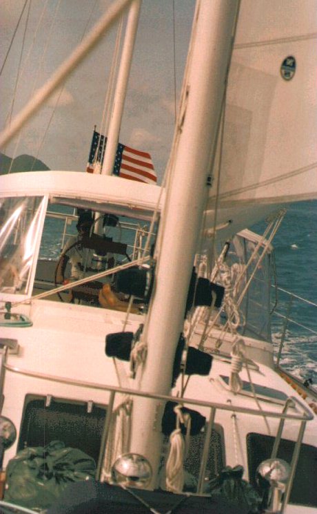
..... It's five to ten days sailing, depending on your boat, the weather, and how quickly you want to get to Cabo San Lucas. Maxi Ocean Racing yachts make the trip in three and one half to four days. Most sailors will arrive in seven to ten days averaging about one hundred to one hundred and twenty five miles per day. Power boats slow down to conserve fuel and travel down the peninsula at about ten knots.From San Diego to Cabo San Lucas, overnight anchorages are scarce. But still, many sailors are streching the trip out, and even anchoring every night weather permitting. The Hurricane season starts June first and runs through November first, althought Hurricanes can occour any time of the year.
..... Rounding Cabo San Lucas
take's you into the Sea of Cortez and a world much
different from the cold Pacific The Sea of Cortez
offers,desert island's, great fishing and secluded
anchorage's.
.....If you don't have the time
to time to take your own boat, there is a new, modern
bareboat charter fleet at " The Moorings", in La Paz. Jet in,
pick up a boat and your sailing in a few hours.
.....If your not a sailor, visit Baja by land. I've always loved the drive down the trans-peninsuler highway. It's paved all the way except for the occasional detour. You can drive the family cars from San Diego to Cabo San Lucas in about 24 hours driving time, stay in a nice hotel every night and eat all your meals in nice resturants. If your planning to drive a large RV or tow a trailer, your driving time will be ten to twenty hours longer. The highway is much wider than it used to be but still, when a maximum width RV passes a 18 wheeler, there isn't much road left. Dont worry. Regular folks like you and I make the drive all the time without incident. But it does require careful planing. Start with one of the many books on driving Baja, such as the Auto Club Baja Guide from AAA, or the Baja Book III. Most large book sellers have a nice selection
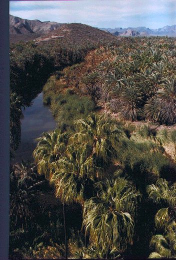
.....Yes this is Baja too. It's not all desert and cactus. This is Baja's only year round river. Located on the Sea of Cortez, just south of Santa Rosalia in the town of Mulaje.(MUL_AH_HAY) This brackish river flows inland for about 2 miles and is replenished by rain runoff during the rainy season. Thousands of date plams grow in the area around the river, and it was a obvious place to build a mission.The Rio Mulaje is home of giant black snook. A 5 foot long fish that vists the river to breed. Mulaje is a charming town with a excellent mission still in daily use. About 15 to 17 hours driving time from San Diego. From Mulaje it's only a 30 minute drive south to the beautiful tropic beachs and campgrounds surrounding Bahia Concepcion.
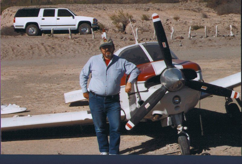
.....Here I am, suffering from to much good Mexican food, (bien comida) in Spanish, and observing the results of a over confident pilot trying to land at night on the unlit dirt runway at Mulaje.The plane hit a pickup truck that was parked in the middle of the runway with it's lights on trying to illuminate the runway. NO ONE WAS HURT, but the starboard landing gear was ripped off and the pickup was attacked by the airplane's prop becoming a total loss, even by Mexican Standards .Many pilots from the US, including flying doctors who volunteer their time talent for the people of many remote villages, make the trip south several times a year. Although paved runways are scarce there are hundreds of dirt strips covering the peninsula. Groups like the flying Doctors and the Baja Bush Pilots keep their members current on Baja Flying conditions.
....The 4X4 Suburban in the background is my favorite vehical to drive Baja, but any well maintained car could make the trip. I like trucks because of their high ground clearence and heavy duty tires. In any vehical you need to be self sufficent. I always travel with hand mechanical tools, tire patch kit with 12volt air compressor, spare car parts, spare fan belt, jumper cables, fluids like oil, antifreeze, trans oil, brake fluid and a gas siphon hose. Water, first aid kit, maps, emergency food and blankets round out my travel stuff. If the roads wash out you might be stuck in the boondocks for a couple of days so, like a boy scout, "Be prepared."
..... Gas stations are about one hundred miles apart from San Quinitin to La Paz so you need to plan your gas stops and know your cars tank size and gas milage. I recommend you drive off the top half of the gas tank. When the guage shows half full stop and buy gas. Availibility is better now, then in past years but shortages of gas are still common. The reason is partially due to the popularity of Recreational Vehicals traveling Baja. The gas stations have small storage tanks for gasoline, about 10,000 gallons. When a RV caravan stops to refuel, they suck up 100 to 200 gallons apeice. So a caravan of 50 or 75 RV's puts a big dent in the local gas supply. If the next gas delivery is two days away you may have to wait with many other people for the gas delivery to show up. In March of 1997 we did not encounter any gas shortages, but we didn't see any large RV caravans on the road either.
.....To give you a idea about the drive south, I'll try to take you step buy step down the Peninsula starting at the US/Mexico border crossing,12 miles south of San Diego at San Ysidro ( E-SEE-DRO) on the US side and Tijuana pronounced (TEE-WAN-AH in Mexico, TEE-AH-WAN-AH in the US) .
Do all your preperation on the US side before you start your trip. You can do the prep in Mexico, it just takes longer. You must buy Mexican auto insurance BEFORE you cross the border. US insurance is not recognized by the Mexican government. I buy liability only, for about $4.00 per day. Collison, fire and thieft insurance, are different then US insurance. In Mexico they usually only cover you in the event of a total loss. No insurance on partial losses. Read your contract carefully or have the agent explain the terms to you. Another reason to be on the US side, unless you speak Spanish. There are lots of drive up insurance booths in San Ysidro and they all charge the same. You may also want to change money into pesos at one of the many money changing stores. This is not a fixed price market, and I recommend you shop at least 3 different changers (Cambio in Spanish). The current exchange rate can be found in the finacial section of any major newspaper. ( December 98 is about 10 new pesos to one US dollar) Don't pay a commission to change dollars to pesos. There is a slight difference between buy and sell exchange rates and thats enought profit for the changers.Its easy to get confused who is selling and who is buying when you change money. Take your time and be sure you understand the transaction. Banks in Mexico have long lines to do anything, and money changers work very well as long as you know what to expect in the way of rate changes. changing pesos back into US dollars is a more difficult task. Pesos are changing in value everyday so everyone wants dollars, not pesos. A good rule is dont change any more than you think you will need.
Your Mastercard, (Bancomer in Mexico) Visa or American Express are good all over Mexico except in gas stations, small resturants and shops. I always pay for gas in Mexico with pesos. Most of the peso meters on the gas pumps dont work in the smaller towns, and a kid with a handheld calculator does the math and holds up the calculator for the customer to see how much is owed. The price of gas is the same all over Mexico, but North Americans are not use to gas being sold in liter's and paid for with pesos. Use your own handheld to double check the attendent and always be sure the pump meter is rolled back to zero before they start pumping the gas.
Mexican Customs (Iduana)
Mexican customs use a red light, green light system. When you drive across the border you will see a signal light in your lane as you cross the border into Mexico. If it is green you drive on through. If it is red you must pull over to the secondary inspection area on your right. Roll down the windows and relax. They may ask you to open your trunk. The inspectors are looking for goods being brought into Mexico that are subject to duty. If you had for example two cases (not bags) of potato chips (or widgets) they would think you are bring potato chips into Mexico for resale and would require duty be paid. Custom laws are being inforced more strictly, then in past years. Years ago they just didn't care. Now with thousand of US citizens living just across the border, duty is collected on all the household goods being brought across the border. If you are driving a RV or towing a trailer expect to be sent to the secondary inspection area. When queing up for the border the far right lane is for campers and vans. I role down all the windows so the customs agents can see inside the car and thats enough inspection most of the time. Have your Car and Trailer Registration ready along with your Mexican Insuranace and Permission from the registered owner of your car or trailer, if the registered owner is a different name than yours. For example a friends trailer, or the vehicle is registered to a trust, or your company. It may seem silly to write a letter giving yourself permission to take your own car into Mexico but remember the custom inspector speaks little English and I am just trying to help speed up the crossing process.
Mexican Tourist Cards
You will also need a Mexican tourist card, which now cost money. You will need proof of citizenship, car registration and the tourist card stamped by Mexican immigration if you travel below Ensenada.
Just across the border, next to the
secondary custom inspection, is the Immigration office (Migracion). There
is little parking but you can find the room. You need to take all your proof of citizenship papers into the Migracion office, pick up the forms, fill them out, go next door to a small bank, pay the fees, then go back to the Migracion office to get the tourist cards. I prefer to use the Immigration office on
the way into Ensenada 65 miles south. Less traffic and better
parking, but closed on Sundays and national holidays. Now with all the military road blocks you really need to have your tourist cards.
Miss the toll road conection, and you will still get through Tijuana, look signs saying
Mexico 1,or signs pointing toward Ensenada.
You wont have a lot of fun going this way but you'll still get there. Most folks don't realize the size of Tijuana . Over one
Million people live there making it the second Largest city
on the west coast of North America, after Los Angeles. Directional
signs are scarce, and the roads are allways torn up
with many detours and few alternate routes indicated. Hopefully
you'll make the toll road OK. The drive to Ensenada takes about
1 hour and 10 minutes. there are lots of nice places to stop,
the most popular being Puerto Nuevo ( New Port). This little
cove became famous for Lobster and now sports about 30 Lobster
resturants. My favorite is the Casa de Langosta's or Lobster
House. If your real hungry they usually have some extra large
Lobsters stashed in the back. just ask for "Muy Grande" or
"Gigantiga".
Just passed the off ramp to the Canta Mar
(Sea Song)
golf resort is a great senic lookout. Stop for a great view of
Todos Santos, (All Saints) Bay.
....Once passed the third toll booth you are in the outskirts of Ensenada. No longer a sleepy little seaport Ensenada's port provides all of the shipping into the Northern part of Baja California. The road splits at the edge of the commercial district. The sign says San Quentin straight ahead but stay by the ocean and go to the right towards" Centro" At the split in the road is the best hotel in Ensenada, the Coral Hotel and Marina. If you want the best this is the place. They have been running half price rates Monday thru Thursday ,but even full fare is worth it. The older Hotels in town are not that much cheaper, but if your looking for a lower price try the El Cid, The Travel Lodge, the El Cortez or the San Nicholes. Dont be afraid to ask to see the room BEFORE you check in to the hotel. Its a common practice with smaller Mexican hotels and motels.
The road makes a sharp left turn by the harbor and passes over some Mexican speed bumps called TOPAS. Look for theMIGRACION (Immigration) office on your left if you need to get your tourist card stamped. Continue to follow the road. Turn to the right at the stop sign, and when you get to a park with three large gold heads on your right, you will be in the tourist center of town. The Hotels are one block to your left. A new editon to many Mexican towns is a HUGE, and I mean real big Flag pole and Mexican Flag. The Flags are located over Military bases and are eighty by two hundred feet and over two hundred feet in the air. Thats Big.
. If your just passing through, keep going straight and the road will turn to the left
and connect with Highway 1 about three blocks inland. There is a
traffic light, and directional signs. Turn right on Highway 1 to continue South, but Ensenada is a good stop for food, hotel and anything you may have forgotten to pack..
If your hungrey, for Breakfest, Lunch or Dinner the best
resturant in town for the last 50 years has been the EL Rey Sol.
Prices are about the same as the US. Great lunches and dinners
are also served at the Casino Royal and La Cueva de las Tigres.
The fish market, ( Mercado Mariscos),
is worth a stop for authentic Mexican Fish Tacos. There are several booths
at the entrance to the fish market which is a block North of the
park with the three gold heads, on the same side of the street.
You eat standing up,off of paper plates and with your fingers
but its so good. You can also stock up on fresh shrimp, abalone
and othe fresh seafoods. I asked one of the fishermen if the shrimp was fresh and he picked up raw shrimp and said "taste one". He ate one so I thought " why not?" The shrimp popped
when I bit into it and was as sweet as candy. We bought 2 kilos
worth (about 4.4 pounds) and ate shrimp for breakfest, lunch and
dinner. I felt like Forrest Gump.
US dollars are
good all over Ensenada but this is about the last place where
everybody seems to know the rate of exchange.The value of the peso is shrinking and is worth about ten new pesos to the dollar.(Dec 98) This is the last "Big City" for about 750 road miles, so be sure you have every thing you need before heading south.
..... The rule in Baja is never wait to the last minute to check into a hotel even if you have reservations. Reservations are not held after 7 PM and the better hotels always seem to fill up quickly.
..... One mile west of the La Pinta down a dirt road is the Celito Linda hotel. Not to bad but hard to get to. On the edge of San Quintin proper is the Melino Viejo ( Old Mill ) hotel. Also down a dirt road and about 3 miles west of highway 1. Not bad but a little hard to find also, follow the signs on Highway 1.
Baja dirt roads consist of the finest dust I have ever seen. Even with the windows tightly sealed the inside of the car fills up with dust in a few miles, unless of course its raining. Then the dust turns into mud the consitancey of pudding. Even with four wheel drive and all terrain tires its a real challange to keep from getting bogged down. After you escape the mud, it dries into a cement that wants to take the paint off your car when you try to clean up. A good soaking with soap and water and lots of time works best. All the hotels have good resturants and are probably the best place to eat in the area. San Quintin is famous for the giant pismo clams (Alma's) that are taken in about 4 feet of water off the sandy beach. The locals feel the clam holes with their toes then use a pitchfork to get the claims out of the sand. When availible they make great eating.
..... Lobster is usually availible at the local resturants and is very good.
... South of San Quintin the road narrows and the traffic is noticabley lighter. You are entering the rural part of the peninsula. Every thing gets scarce from here to La Paz, about 650 miles away.
Six miles south east of El Rosario, the highway crosses the Rio Rosario. This Baja river is dry except after a heavy rain. The new bridge crosses the quarter mile wide river and keeps the highway open during the winter months. The river would cut the peninsula in half twenty years ago, stranding travelers for weeks. My first fording of the river was during a cold wet January rain storm. Traffic was stopped on both sides of the river, and we could only stare at each other. The Mexican Army was directing traffic and a young private looked under my truck and saw I had four wheel drive and motioned me through with the barrel of his automatic rifle. I protested in English which didn't change a thing. "Pasa, Pasa" he kept saying, "You Pass, You Pass". It was solid water for about 1000 feet ranging from six inches to holes three feet deep. A couple of times I thought I felt the truck floating. The current was trying to push us down stream and I kept fighting to hold a straight course. I hoped and prayed the road hadn't totaly washed out. I finally made it, to the cheers of the folks on the Southern side of the river. Some had beeen waiting for two days for a break in the weather. I was lucky. Very lucky. Every time I cross over the bridge I think of that January day and thank God I made it across the river. In the same situation today I would turn around and go back to the hotel and wait for better weather. Had I slipped off the road bed we would have been washed out to sea and , well, I wouldn't be writing this.
El Roserio to Cantavina Highway One leaves the valley of the El Rosario river and slowly climbs to the top of ridgeline at a altitude of 3000 feet. It twist and turns thru the forest of Bojum trees. The Bojum tree, or more properly called the Cero cactus is a very primitve tree found only in this part of Baja. Tall and skinny it looks a stick that took root. The leaves and branches are very small and it survives the harsh and mostly dry Baja climiate. Heading towards Cantavina you travel across the ridgeline of the rolling hills that cover this central part of the peninsula. Rocks seem to be getting larger and soon there is nothing but rocks piled at times hundreds of feet tall. The Mexican lovers have taken this strech of rocky ground as their own. The names of these romantics are arranged in stones by the thousands. "Juanita mi corazon", "Lupe y Jesus" and other works of endearment cover both sides of the road.
About a quarter of a mile from Catavina the road dives into a deep vado (revine or wash). A short walk to the East and up to the top of a small hill are some interesting Cave Paintings. The Hotel can give you directions if you miss it on the way down..Cantavina is only a wide spot in the road with a La Pinta Hotel, Pemex gas station and a truck stop resturant and auto and truck repair shop. BUY GAS FIRST then check into the hotel. The gas tanks are small and run out of fuel quickly and the Hotel is small and fills up quickly also. The Hotel Resturant is very good but is often filled early with folks staying in RV's so go to dinner early if you want to eat there. Like everything in Baja they often run out of Tables and Food. The truck stop across the street serves a good meal but is open to the cold evening breezes so dress warmly.
South of Cantavina the road goes up and down through some vados ( washes, normally dry unless it is raining ) and then back to its course down the center of the peninsula. About twenty miles South of Cantavina is a major dirt road that heads east to the Sea of Cortez and Puertecitos and Bahia Willard, both small tourist areas. The main town on that part of the Sea of Cortez is San Felipe ( SAN PHIL-E-PAY) which is a long way back to the North. The dirt road will take you there and back to the US/Mexico border but its a long hard dirt road with lots of wash outs. Dont try it unless your well prepared. If you must go to San Felipe use Highway 3 out of Ensenada. This dirt road intersection is marked by a road sign but is easy to miss as it faces South.
South of this crossroads is Lake Chapala. In the rainy season you may even see water in this shallow lake which has no outlet. When wet the lake is only a few inches deep and very muddy, when dry its a major dust bowl, so I don't recommend that you try to drive on it even if you have four wheel drive and big tires.Many do anyway and many get stuck.
Another thirty or so miles South is the intersection with the paved road to Bahia de Los Angeles, or L.A. Bay as it is popularly known. Its a 41 mile trip to LA Bay and the Sea of Cortez. This popular fishing and camping spot has a gas station, motel and dirt air strip. The camping in the area is wild and wide open. About 12 miles north of LA Bay on a dirt road that follows the shoreline is Punta Gringa. A beautiful headland with sandy beaches and clear water. One of the best camping spots on the Northeastern part of the peninsula. LA Bay is just far enough away to make it a tough lunch stop. Better to plan some time and enjoy the area.
Continuing South on Highway 1, the road starts to wind down out of the central highland and down to the Magdalena Plain just south of the small town of Rosirito. It does not take to much imagination to realize this country was at the bottom of the sea at one time. The trees, then the catus, then the bushes start to dissapear. The road becomes staight and rolly and very narrow without sholders. WATCH YOUR SPEED After all the twisting and turning it is easy to relax and forget your speed. I looked down at the speedometer one time to find that I was doing 100 miles per hour. No trees, or telephone poles to give you some speed reference. The town of Jesus y Maria is a farming town that has a gas station that usually has gas. As you approach the 28th paralell you will start to see a catus in the center of the road that seems to be getting bigger and bigger. Soon it will turn into a 150 foot steel eagle monument built as a public works project to mark the boder between Baja California Norte (NORTH), and Baja California Sud (SOUTH). The only problem was they built it out in the middle of nowhere. Originally there was a school build under the eagle, hotel, trailer park and gas station. But all failed and now the La Pinta Hotel, and a Army base in the old school are all that survive. This is a favorite check point for guns and drugs so be prepared to be stopped and searched by the Army. As you cross the border into the South you also switch to Mountian time from Pacific time. Off to the west is the town of Gurerro Negro. GER-AIR-OH NAY-GROW which in English means Black Warrior.
Much has been written about Gurerro Negro. It is a company town, which lays claim to the worlds largest evaprtaive salt works in the world. The flat plains are divided into huge drying pens by large earthen dikes. The sea water is allowed to run in a high tide. The dike is closed with a bull doser and the hot Baja sun does the rest. Later the salt is gathered up by huge machines and then taken out on top of the dikes for several miles where it is loaded onto small boats and taken another twelve miles out to sea to Cedros Island where it is further processed and loaded on to large ships and sent world wide. The Japanese company that owns the salt works is the towns major employer. Just south of the town and salt works is the world famous Scammons Lagoon. This is the spot where the grey whales go to spend the winter and bare their calfs. There are signs about four miles south of town, on Highway one, giving directions down a dirt road to the whale watching areas. Often small boats or Pongas, are availible to take visitors out into the lagoon and get a real close up view of the gray whales (Balinas), that visit here to mate and calf their young.
Although I find Guerro Negro to be one of the uglyest towns in Mexico, if you drive out the dike to the salt loading docks you will be surprised by a very large and beautiful salt marsh area with birds and lots of greenery. Not at all like the surrounding Desert. Take the right hand turn off Highway one into Guerro Negro and drive thru town. You will see the road wander off to the right just past the dirt airstrip in the Western part of town. Turn right. You cant get lost. The road goes almost three miles on top of the dike out through the salt marsh to the loading pier.
The hotels in town are very poor at best. The food stores are pretty good but your in a remote spot and most familier brands will be in short supply. The La Pinta hotel under the big eagle is OK in a pinch, but there is just not much tourist accomodation in Gurerro Negro. The weather is this towns worst enemy. The wind always seems to blow off the cold Pacific ocean and it seems to be too hot or too cold, just about all the time. When Mexico One leaves Guerro Negro, it turns southeast and is a straight line for almost sixty miles. Again, Watch Your Speed This can be a very dangerious strech of highway. However there is a reward waiting to greet you. Ninety miles further southeast is the prettiest town on the Baja Peninsula. San Ignacio, and thrity miles past San Ignacio your first view of the Sea of Cortez DRIVING BAJA SOUTHERN SECTION .................................................
![]()
 Links to other sites on the Web
Baja Beach and Hotel Reports
La Paz Bareboat Charters
Baja Information Pages
Global travel links
Instant Baja Weather
![]()
.....FAQ Is Baja safe for Americans?.... In 30 years of Baja travel I've never had a problem. But that doesn't mean bad things can't happen. Learn and obey the laws, be polite, and the Mexicans open their homes and their heart's Absolute NO-NO'S in Mexico; NO DRUGS- NO GUNS. In March of this year we were stopped a total of 6 times by Mexican solders between Ensenada and Loreto. It's hard to argue with a 17 year old army private who dosn't speak English, and is equipped with a AK-47. Mexico is goverened by Nepolianic Code. You are guilty untill you can prove yourself innocent, and arrest is presumtion of guilt. I can't make it any plainer than that. Most of Mexico is crime free and you can safely walk around at almost any time or in any place.
Questions? Comments? I would love to hear of your experience in Baja and will use your information to keep this site current. E-mail me at Lexusbob@aol.com