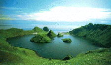
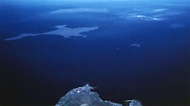
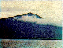
15.Yankicha Island
15. It is a very unique island which attracks many biologists around the world because of the island's
biological inhabitants. In two years, over 60 new species have been discovered which are mostly insects,
spiders, and mollusks. The picture shows the crater bay which also has many unknown marine life.

16.Ushishiri or Ushichi Island (Ushishir in Russian)
16. In Ainu language, Ushishiri means the land created by god. The god of lightning Kannakamui once lived
on this remote island according to the Ainu legend. The island is divided into northen island and southern
island but when the sea level is low, you can walk across from one island to another. Around the island, there
are many rocks and the island is very rocky as well. It has a very big bay of Kraternaya which many hot springs
come out. Also, this island is home for many seagulls which many makes nest on the island. Near the island of
Ushishiri, there is an island called Habushuka where many birds like Etopirika and sea crows lives.
17.Ketoi Island (Ketoy in Russian)
17. Sorry! No Data available about the island.

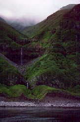
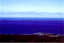
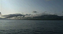
18.Shimushiri or Shinshiru Island (Simushir in Russian)
18. Shimushiri or Shimoshiriis the second largest island of the Southern Kuril island (or central Chishima). Before the World War 2, the island was used mainly for the production of fox furs and raindeer meats. Also, there were many staions
for catching whales. However, after the occupation of the Soviet Union, the island served as a border patrol station.
At the background of the picture, you can see the beautiful volcano of Shimushiri Fuji or Suehiro-take (Mount Zavaritskii
in Russian).
19. Buroton Island (Bourotona in Russian)
19. A tiny island inward to Okhotsk Sea which is named after a British explorer "William Broughton".

20.Chirihoi or Buratto-Chiripoi islands (Brat Chiripoev in Russian)
20. In Ainu the island mean black brothers because of their masculine shape. However, Chiripoi island is also called
"Floating Flower island" because there are many plants on the island. There are many volcanos and Sulfurs can be found
on the islans. During the World War 2, the islands were used to dig Sulfurs. There are two islands which are called Kita-jima and Minami-jima.
21.Uruppu Island (Urup in Russian)
21. In Ainu, Uruppu means salmon. Uruppu is the Southernmost island of the Kuril islands but are located in the centeral of the Chishima islands.
It is a vocanic island which in 1643, a Dutch Navigator discovered this island and named it "Companies' Island". It has been disputed between Japan and Russia for many years.
By the Treaty of Shimoda (February 7, 1855), The island served as the border between Japan and Russia where islands
below Etorofu belonged to Japan while island above Uruppu belonged to Russia. In reality, Japan was claiming Uruppu
as integral Japanese territory and famous Japanese explorer (Kondo Juzo) even explored the island and drew the island
as if it was part of Japan. Unfortunately, Japan did not have enough power to claim Uruppu. After the Soviet occupation,
it was used as border patrol station and national park to preserve sea lions. Today, the stations are abandoned and the
troops are living on their own. There are no permanent resident on the island. "Click here for the imformation about the Uruppu Inccident"
22.Etorofu Island (Iturup in Russian)
22. Etorofu island is the biggest island of the Chishima island where it is the integral Japanese territory.
When the Dutch Navigator discovered this island, he named it "Staaten Island". Japan knew about this island for quite a while but formal colonization started in 1786. Kondo Juzo played a big role in exploration and creating a road between Shana village and Naibo village. However in 1807, the island have been raided by the Russian bandits which claimed some Japanese lives. Russia claimed Etorofu but in the Treaty of 1858, Russian government officially recognized the island as Japanese possesion and relinquished its claim on the island. The island has been under the Nemuro-subprefectorial government. This island had three county which are Furubetsu, Shana, Shibetoro and Etorofu. However in August 31, 1945, Soviet troops illegally entered the island and expelled the Japanese civillians which was against the Yalta aggreement. All Japanese and Ainu civillians escaped the Soviet oppression or was later expelled.
23.Kunashiri Island (Kunashir in Russian)
23. Kunashiri means black island in Ainu. Kunashiri island can be seen from Hokkaido very clearly almost everyday. It is a
very beautiful island with many trees, bamboos, bear, and other living species. The island has a very high volcano called ChaCha-Take
(TyaTya Mountain in Russian). It had the higest population of the all Chishima island with a town called Tomari. All Japanese were
expelled after the World War 2.

14.Shikotan Island
24. Shikotan means best settlement in Ainu because of its beautiful nature. The island was settled by the North Kurilsky Ainus of Poromushiri and Shumushu when the North Kurils were given back to the Japanese Empire. Unfortunately, the Ainus in the North were assimulated to the Russian culture which gave high risk of becoming a spy for Russian Empire. the Entire population of the North Ainu were moved to Shikotan and resettled. Unfortunately, they were not able to adapt to the different envirement which lead them to extinct. WE Japanese must remember that this was one of the biggest mistakes we have ever made to our brother Ainu. The island is filled with natural harbours (In the picture is Anama harbour). It had a settlement of Anama and Shakotan. All Japanese were expelled after World War 2.
15.Habomai Islands (Malaia Kurilskaia griada in Russian)
25. Habomai islands are very small islands which have very low elevation. Sometimes the islands can be mistaken as reefs. The islans
include Akiyuri island (Anuchina in Russian), Shibotsu island (Zelionyi in Russian), Suisho island (Tanfileva in Russian), Taraku island (Polongskogo
in Russian), Yuri island (Iurii in Russian) and Kaigara islands. Most of the islands are used to place border patrol stations and light houses.
Many Japanese look at the islands through bonoculars from cape Noshappu to see the Russian people's lifestyle. These are one of the islands which
Russia wants to use to bargain for Russo-Japanese peace treaty. Russia is willing to give back only the Habomai islands and Shikotan island to get
Japan sign for the Russo-Japanese peace treaty and for Japanese investment in Siberia. Japan rejected the plan.

16.Kaigara archepelogo (banka Opasnaya in Russian)
26. Kaigara means Sea shell in Japanese. You can see the lighthouse on the island. It is the closest island which is occupied by Russia illegally.
Japanese fishermen fish in these area with humiliating permittion from the Russian government.
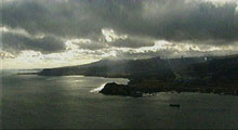
17.Goyomai Strait (Goiomai in Russian)
27. This is the scene from cape Noshappu. You can see the Habomai islands at the back. Thsi strait is now temporarily the boundary strait
between Japan and Russia.


