| Balmaha to Rowardennan (11.75 km) |
| Introduction Milngavie Balmaha Rowardennan Ardlui Crianlarich Tyndrum Bridge of Orchy Kingshouse Kinlochleven |
|
An easy day along the "bonny banks" of Loch Lomond was my reward for the rather strenuous trip yesterday. The shoreline is not followed closely with lots of diversions over headlands and into oakwoods. There are a few places where the parallel minor road is followed and these can be harrowing in the heavy summer tourist traffic since the road winds about with blind bends and crests. Luckily the rest of the walk compensates for the danger and hassle of the road. In hot weather, you may be tempted into swimming in the loch. However be aware that the lakebed drops steeply from the shore and the deeper water is always very cold - keep to the shallows! I was not tempted on this grey day but there was a brave windsurfer out on the loch.
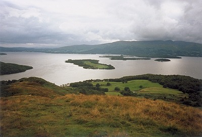
The journey along the shores of Loch Lomond is essentially from the Scottish Lowlands to the Highlands. At Balmaha, the loch is broad and relatively shallow with many islands dotted on its expanse. The hills to either side are low and there is almost a plain stretching south towards Glasgow. As you travel to the north, the loch narrows, becomes deeper and there are only a few small islands. On each side of the loch the hills become higher until the first Munro of Ben Lomond is reached at Rowardennan. Further north the loch is rarely more then 1500 metres wide (about a mile) and the slopes enclosing it become even steeper.
Depart Balmaha on that boardwalk between the road and the loch that shirts around the head of the bay to an old jetty. The WHW then climbs to the right up to the flat top of the Craigie Fort hill and a cairn marking the official opening of the Way. The islands in the loch can be appreciated from here. They all have a varied history and have mostly been inhabited in the past. The nearest island (Inchcailloch) has a typical history, starting with the establishment of a nunnery during the beginning of Scottish Christianity, providing a refuge for the clans of MacFarlane and MacGregor, farmland until about 1770 and then allowed to revert to woodland.
From Craigie Fort, the Way drops down the hill through pleasant open oakwoods and back to the shore. Arrochymore Point is traversed to the carpark at Milarrochy. Here a private campsite is avoided by a quick diversion to the road as far as the bridge on the Blair burn. The Way wanders up to Blair Cottage on a nice trail on the west of the road, but sheltered from it by trees. At the cottage, the path heads to the left into gloomy woods up to a point 53 metres above the loch (definitely no view!). A long descent through more open deciduous woodlands brings you on an curve back to the road at Castel. The 'Castel' is the network of dykes and ditches on Strathcashell Point which are thought to be an Iron Age fortification.
More road-walking takes the WHW past a campsite (with a handy shop) and up to Anchorage Cottage where there is a nice view across the loch to the green fields and forests of Luss on the opposite shore. The road is left at Sallochy for a path through more fine oak woods and a climb over a rocky prow (preventing progress along the shore). The shore is regained from the ridge and followed until a steep climb through Ross Woods rises to the highest point of today's walk (73 whole metres) in the middle of Ross Point. A long gradual descent over the next kilometre meets the shoreline again at the cottage to the south of Coille Mhór Hill.
The Way passes behind an alder swamp to cross over a burn and climb over a dark larch-clad knoll to emerge suddenly at a small carpark near the tiny Lochan Maoil Dhuinne. The route is then along the lochshore - firstly among oaks and then beside more mixed, tangled woods. The thickets of rhododendron are struggled through after a few hundred metres to reach the road again only 300 metres south from Rowardennan Hotel. This offers accommodation, though the Rowardennan Youth Hostel is only 750 metres further north along a forest road.
A good reason for staying in Rowardennan is the chance to climb Ben Lomond. This is a great option on clear days with one of the best views in Scotland on offer. The well-trod popular path leaves Rowardennan by the hotel and climbs eastwards through forest before bending to the north to gain the Sron Aonaich ridge. The ridge leads up to the crags lying to the north of the summit and the path follows them west up to the top. A very fit person could do the walk and the climb in one day but ordinary mortals will stay overnight to split the effort into two days. I stayed at the youth hostel hoping that the grey weather would clear up but if anything the weather was thicker the next day so I continued along the West Highland Way.
|
|
|